Franconian Switzerland

Franconian Switzerland (German: Fränkische Schweiz) is an upland in Upper Franconia, Bavaria, Germany and a popular tourist retreat. Located between the River Pegnitz in the east and the south, the River Regnitz in the west and the River Main in the north, its relief, which reaches 600 metres in height, forms the northern part of the Franconian Jura (Frankenjura).
Franconian Switzerland was given its name by Romantic artists and poets in the 19th century who compared its landscape to Switzerland. The Franconian Switzerland is famous for its high density of traditional breweries.
Name
The region was once called Muggendorfer Gebürg (Muggendorf hills). The first tourists arrived during the age of Romanticism. Two law students of Erlangen University, Ludwig Tieck and Wilhelm Heinrich Wackenroder have been credited as "discoverers" of the region. The episode "Eine Reise in die Fränkische Schweiz" in their joint production Franz Sternbalds Wanderungen[1] (Berlin, 1798) enthralled many contemporaries.

The 1820 book Die kleine Schweiz (Little Switzerland), written by Jakob Reiselsberger of Waischenfeld, gave the region its name. In 1829, a book by German salesman and local historian Joseph Heller, Muggendorf und seine Umgebung oder die Fränkische Schweiz (Muggendorf and its surrounding or the Franconian Switzerland) was published.
The description Switzerland was common during the 19th century for landscapes with mountains, valleys and most significantly rocks, e.g., Saxon Switzerland, Marcher Switzerland, Mecklenburg Switzerland and Holstein Switzerland.
Geography
Franconian Switzerland is the northern part of the Franconian Jura. It is often loosely defined as the region bounded by the rivers Main to the north, Regnitz to the west and Pegnitz to the east or by the motorways of the A 70 to the north, A 9 to the east and A 73 to the west. However, the actual region of Franconian Switzerland is only the catchment area of the River Wiesent.
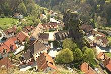
The region covers parts of the counties of Bamberg, Bayreuth and Forchheim. Its best known settlements include Pottenstein, Gößweinstein, Muggendorf, Ebermannstadt, Streitberg, Egloffstein and Waischenfeld.
It boundaries are:
- in the north: Obermainland
- in the east: Bayreuth
- in the south: Erlangen
- in the west: Forchheim
- im Nordwesten: Bamberg
Information about Franconian Switzerland may be found inter alia in the Franconian Switzerland Museum in Tüchersfeld with its comprehensive regional collections. It is housed in the so-called Jew's Court (Judenhof) below two steep rock pinnacles.
Franconian Switzerland Trade Association
The following 18 municipalities across 2 counties belong to the Franconian Switzerland Trade Association (Wirtschaftsverband Fränkische Schweiz):
Geology

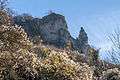
In the White Jurassic, about 161 million to 150 million years ago, a shallow sea lay across the whole of southern Germany. During this period, thick rock sequences were deposited on the seabed as the earth's crust constantly sank. The landscape of Franconian Switzerland is strongly influenced by the resulting limestone and dolomite rocks of the White Jurassic. It is a typical karst landscape with deeply incised river valleys and dry, arid plateaus. Many fossils, especially ammonites, may be found in the limestone strata.
In the late Jurassic, uplifting of the European continental plate caused the sea to recede and larger areas of land formed at the beginning of the subsequent Cretaceous period. During this time there was a tropical climate and there was intense weathering of limestone and dolomite rocks. During the Cretaceous a sea again advanced into the region of the Franconian Switzerland.
In the Tertiary period, the sea receded again due to local uplifting and partially exposed the Jurassic landscape.
Mountains and hills
The most prominent peak is commonly known as "Walberla", a table hill east of Forchheim. Its official name is the Ehrenbürg. The Ehrenbürg consists of two peaks, the Rodenstein (532 m)and the Walberla (512 m). On the hilltop is a small chapel, the Walburgis Chapel, which was first mentioned in a 1360 manuscript. This chapel gave the hill its name. Furthermore, there is also an annual festival on the hilltop on 30 April, the birthday of Saint Walburga, which attracts thousands of people.
Other popular high points are:
- Leienfels (near Pottenstein), 590 m
- Spiegelfels along with the Pfarrfelsen near Affalterthal, Markt Egloffstein, 468 m
- Wichsenstein (near Gössweinstein), 587 m
- Signalstein (near Wolfsberg, Obertrubach), 582 m
- Little Kulm (near Körbeldorf), 623 m
- Hohenmirsberger Plateau (near Pottenstein), 614 m
- Neubürg (near Wohnsgehaig), 587 m
- Tannenberg, 599 m
- Graubühl (near Creussen), 569 m

The rocks of Franconian Switzerland's mountains and hills are important climbing. With more than 6,500 routes it is one of the best developed climbing areas in the world.
Important climbing areas are:
- Trubach Valley
- Walberla
- Wiesent Valley
- Leinleiter Valley
- Püttlach Valley
- Aufsess Valley
Caves

There are countless caves in Franconian Switzerland, of which the Devil's Cave (Teufelshöhle) near Pottenstein is the most famous. The region is a typical example for a Karst topography.
Accessible caves:
- Binghöhle (near Streitberg)
- Teufelshöhle (near Pottenstein)
- Sophienhöhle (in the Ailsbach valley)
- Oswaldhöhle (near Muggendorf)
- Rosenmüllershöhle (near Muggendorf)
- Quackenschloss (near Engelhardsberg), cave ruin
- Zoolithenhöhle (near Burggailenreuth)
- Esperhöhle (near Gössweinstein)
- Förstershöhle (in the Zeubach valley)
- Schönsteinhöhle (in the Long Valley)
- Klauskirche (near Betzenstein)
- Riesenburg (near Doos)
- Hasenlochhöhle (near Pottenstein), known for having housed people during the Stone Age.
Castles


Franconian Switzerland is located along the so-called Castle Road (Burgenstraße), which connects more than 70 castles, palaces and fortresses between Mannheim and Prague. Most of these castles were constructed in the Middle Ages. The following castles and castle ruins can be visited:
- Wolfsberg Castle ruins
- Unteraufsess Castle
- Neideck Castle ruins
- Neidenstein Castle ruins
- Streitburg Castle ruins (Markt Wiesenttal)
- Gössweinstein Castle
- Egloffstein Castle
- Schloss Greifenstein, seat of the Stauffenberg family.
- Rabenstein Castle
- Rabeneck Castle
- Pottenstein Castle
- Waischenfeld Castle
- Bärnfels Castle ruins
- Leienfels Castle ruins
- Stierberg Castle ruins
- Wildenfels Castle ruins
Customs
Franconian Switzerland is the origin of the so-called Osterbrunnen. It describes the colorful decoration of public water wells during the Easter season. During the time of modernization and the construction of canalization, this custom had lost its significance. Only in the early 1980s, it was rediscovered and in 1986 169 villages again decorated their water wells. Today, more than 200 villages decorate their village well with coloured easter eggs. The main reason for this custom is probably the significance of water for the arid high plateau of Franconian Switzerland. The Bieberbach Osterbrunnen (Egloffstein) was admitted to the Guinness Book of Records as "the largest Osterbrunnen of the world".
Tourism

Franconian Switzerland is one of the oldest tourist regions in Germany. The first travelers arrived at the beginning of the 19th century. The most attractive tourist locations are the many caves.
A large range of outdoor activities is possible in the area. Beside countless hiking paths the area is popular for its great rock climbing and canoeing options. Most important is however the impressing nature, which should be preserved by every visitor.
Home to the annual Frankonian Switzerland Marathon, beginning in Forchheim and slowly climbing to Sachsenmühle-Wende, then back to Ebermannstadt, the area includes 375 km of some of the best trails for running, Nordic walking, and rambling in Germany maintained by the European-Community-funded Running Experience Project which was launched in July 2011.
The Franconian Switzerland Steam Railway (Dampfbahn Fränkische Schweiz) or DFS is a museum railway based in Ebermannstadt[2] that operates steam and diesel specials on Sundays and on public holidays.
Image gallery
-

Aufsess river
-

Pottenstein
-

landscape
-
Ehrenbürg
-

village chapel
-

village chapel
-

Schloss Greifenstein, seat of the Stauffenberg
-
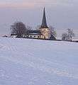
village chapel
Literature
- In English
- Milner Barry, R.: Bayreuth and Franconian Switzerland, London, S. Sonnenschein, Lowrey & Co., 1887.
- In German
- August Sieghardt: Fränkische Schweiz. Glock und Lutz, Nürnberg 1971, aus der Bibliothek Deutsche Landeskunde
- MERIAN Monatshefte, 6/XXVI: Fränkische Schweiz. 1973
- Friedrich Herrmann: Höhlen der Fränkischen und Hersbrucker Schweiz. Regensburg 1980
- Brigitte Kaulich, Hermann Schaaf: Kleiner Führer zu Höhlen um Muggendorf. Nürnberg 1980, ISBN 3-922877-00-1
- Fritz Krause: Großer Fränkische Schweiz Führer. Deutscher Wanderverlag Dr. Mair & Schnabel & Co, Stuttgart 1981, ISBN 3-8134-0135-9
- Peter Poscharsky: Die Kirchen der Fränkischen Schweiz. Palm & Enke, Erlangen 1990, ISBN 3-7896-0095-4
- Rainer Hofmann et al.: Führer zu archäologischen Denkmälern in Deutschland: Fränkische Schweiz. Theiss, Stuttgart 1990, ISBN 3-8062-0586-8
- Hans-Peter Siebenhaar, Michael Müller: Fränkische Schweiz. Michael Müller, Erlangen 1991, ISBN 3-923278-15-2
- Gustav Voit, Brigitte Kaulich, Walter Rüfer: Vom Land im Gebirg zur Fränkischen Schweiz. Eine Landschaft wird entdeckt. Palm & Enke, Erlangen 1992, ISBN 3-7896-0511-5
- Gustav Voit, Walter Rüfer: Eine Burgenreise durch die Fränkische Schweiz. Palm & Enke, Erlangen 1993, ISBN 3-7896-0064-4
- Rolf K. F. Meyer, Hermann Schmidt-Kaler: Wanderungen in die Erdgeschichte (5): Durch die Fränkische Schweiz. Dr. Friedrich Pfeil, München 1992, ISBN 3-923871-65-1
- Reinhard Feldrapp, Willi Feldrapp, Adolf Lang: Die Fränkische Schweiz. H. Stürtz, Würzburg 1992, ISBN 3-8003-0210-1
- Toni Eckert, Susanne Fischer, Renate Freitag, Rainer Hofmann, Walter Tausendpfund: Die Burgen der Fränkischen Schweiz; Ein Kulturführer. Gebietsausschuss Fränkische Schweiz 1997, ISBN 3-9803276-5-5
- Stephan Lang: Höhlen in Franken - Ein Wanderführer in die Unterwelt der Fränkischen Schweiz. Verlag Hans Carl, Nürnberg 2000
- Hardy Schabdach: Unterirdische Welten - Höhlen der Fränkischen und Hersbrucker Schweiz. Verlag Reinhold Lippert, Ebermannstadt 2000
- Thomas Hübner: 25 mal Fränkische Schweiz. Heinrichs-Verlag GmbH, Bamberg 2007, ISBN 978-3-89889-058-8
References
External links
| Wikivoyage has a travel guide for Franconian Switzerland. |
- Historical books of the Franconian Switzerland in the digitale collection of the Bamberg State Library
- The Franconian Switzerland
- Walking World
- Franconian Switzerland 360° Panoramic Images
- Franconian Caves
- Images from the Franconian Switzerland
- Caves of Franconian Switzerland - a journey to and into the german Karst