Frévillers
| Frévillers | |
|---|---|
|
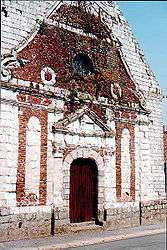
Entrance to St. Anne’s church | |
 Frévillers | |
|
Location within Hauts-de-France region  Frévillers | |
| Coordinates: 50°23′50″N 2°31′25″E / 50.3972°N 2.5236°ECoordinates: 50°23′50″N 2°31′25″E / 50.3972°N 2.5236°E | |
| Country | France |
| Region | Hauts-de-France |
| Department | Pas-de-Calais |
| Arrondissement | Arras |
| Canton | Aubigny-en-Artois |
| Intercommunality | Communauté de communes de l'Atrébatie |
| Government | |
| • Mayor (2008–2014) | Guy Vasseur |
| Area1 | 5.07 km2 (1.96 sq mi) |
| Population (1999)2 | 253 |
| • Density | 50/km2 (130/sq mi) |
| Time zone | CET (UTC+1) |
| • Summer (DST) | CEST (UTC+2) |
| INSEE/Postal code | 62362 / 62127 |
| Elevation |
141–187 m (463–614 ft) (avg. 172 m or 564 ft) |
|
1 French Land Register data, which excludes lakes, ponds, glaciers > 1 km² (0.386 sq mi or 247 acres) and river estuaries. 2 Population without double counting: residents of multiple communes (e.g., students and military personnel) only counted once. | |
Frévillers is a commune in the Pas-de-Calais department in the Hauts-de-France region of France.
Geography
A farming village situated at the highest point in the département, 16 miles (25.7 km) northwest of Arras, at the junction of the D72 and the D74 roads.
Population
| Year | 1962 | 1968 | 1975 | 1982 | 1990 | 1999 |
|---|---|---|---|---|---|---|
| Population | 232 | 235 | 231 | 226 | 232 | 253 |
| From the year 1962 on: No double counting—residents of multiple communes (e.g. students and military personnel) are counted only once. | ||||||
Places of interest
- The church of St.Anne, dating from the eighteenth century.
- Vestiges of an old castle.
See also
References
External links
| Wikimedia Commons has media related to Frévillers. |
- Frévillers on the Quid website (French)
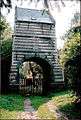 The old gatehouse
 Sheep and the gatehouse
This article is issued from Wikipedia - version of the 11/6/2016. The text is available under the Creative Commons Attribution/Share Alike but additional terms may apply for the media files.