Fox River (Illinois River tributary)
| Fox River | |
|---|---|
|
Fox River and its watershed | |
| Country | United States |
| Basin | |
| Main source |
1 mi (1.6 km) southeast of Colgate, Wisconsin 942.78 ft (287.36 m)[1] 43°11′09″N 88°11′42″W / 43.18583°N 88.19500°W[2] |
| River mouth |
Illinois River at Ottawa, Illinois 460.28 ft (140.29 m)[1] 41°20′37″N 88°50′26″W / 41.34361°N 88.84056°WCoordinates: 41°20′37″N 88°50′26″W / 41.34361°N 88.84056°W[2] |
| River system | Mississippi River |
| Physical characteristics | |
| Length | 202 mi (325 km) |
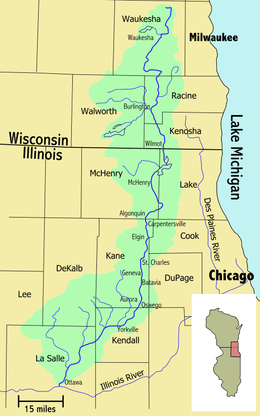
The Fox River is a 202-mile-long (325 km)[1] tributary of the Illinois River, flowing from southeastern Wisconsin to Ottawa, Illinois in the United States. The Wisconsin section was known as the Pishtaka River in the 19th century.[3] There are two other "Fox Rivers" in southern Illinois: the Fox River (Little Wabash tributary) and a smaller "Fox River" that joins the Wabash River near New Harmony, Indiana.
Wisconsin
The Fox River rises in the Halbach Swamp,[4] 1 mi (1.6 km) southeast of the community of Colgate, Wisconsin[2] and flows past Brookfield, Waukesha, Big Bend, Waterford, Rochester, Burlington, Wheatland, Silver Lake and Wilmot, for a total of 84 miles (135 km)[1] in Wisconsin.
A major dam in Waterford forms a 1,200-acre (4.9 km2) navigable waterway which is one of the busiest in southeastern Wisconsin. The river is generally navigable from the Iron Bridge (now a concrete bridge) in Tichigan, Wisconsin (just south of Big Bend) down to the dam. The river connects several small lakes in this section, and one large lake, Tichigan Lake and one smaller lake, Buena Lake. The entire area including connected lakes and the Fox are often referred to as Tichigan Lake.
At the southern end of this section, Foxwood Isle separates the main dam to its west and a spillway to the east.
A small dam is present just a few miles south in downtown Rochester. The river then flows unobstructed through Burlington, where it joins the White River, and on to Wilmot. This is a popular and picturesque day-canoe trip never straying far from the road, but often just out of sight of it.
Flooding is common on this section of the river, especially near Wheatland to the border.
Illinois

The river enters Illinois where it widens into a large area of interconnected lakes known as the Chain O'Lakes. Fox Lake is the largest village in this area. From the chain, the river flows generally southward for 118 miles (190 km),[1] until it joins the Illinois River at Ottawa. Illinois towns and communities that are on the Fox River include (from north to south) Johnsburg, McHenry, Holiday Hills, Island Lake, Burtons Bridge, Port Barrington, Cary, Fox River Grove, Algonquin, Carpentersville, West Dundee, East Dundee, Elgin, South Elgin, St. Charles, Geneva, Batavia, North Aurora, Aurora, Montgomery, Oswego, Yorkville, Plano, Millington, Sheridan and Ottawa. Collectively, the area surrounding the Fox River is known as the Fox Valley. Around 1 million people live in this area.[5]
Native American tribes that lived near the Fox River included the Potawatomi, Sac, and Fox tribes.
The Fox River has 15 dams, including McHenry Dam, which raises the river slightly to maintain depth in the Chain O'Lakes in northern Illinois, and a hydroelectric dam near Ottawa. In the winter, bald eagles can be found nesting along the banks.
Early in the history of Illinois, the Fox River provided water for the Illinois and Michigan Canal via a feeder canal, allowing the canal to pass over the Fox River on an aqueduct.
Flooding
The river has flooded at least three times within the last fifty years, with some responsibility placed upon the area's recent rapid growth, especially the area downstream of Aurora. In 1996, a massive flood devastated the area. The Farnsworth House, a residence designed by Ludwig Mies van der Rohe in 1952, received substantial damage through the fracture and failure of one of the house's windows. In 1998, winter melt sent water downstream too fast for the still frozen ground to be able to handle without flooding the valley. In 2008, the remnants of Hurricane Ike moved north into Illinois, releasing a massive amount of water in the Fox River Valley that was unable to be controlled.
See also
- List of rivers of Illinois
- List of rivers of Wisconsin
- Fox River Trail (Illinois)
- Tri-Cities, Illinois
References
- 1 2 3 4 5 U.S. Geological Survey. National Hydrography Dataset high-resolution flowline data. The National Map, accessed May 13, 2011
- 1 2 3 "Fox River". Geographic Names Information System. United States Geological Survey. Retrieved 15 August 2012.
- ↑ Increase A. Lapham (1855). "Ancient Works in The Basin of the Pishtaka River". The Antiquities of Wisconsin. Retrieved 2015-09-02.
- ↑ Effects of Lowhead Dams on Unionids in Fox River, Illinois
- ↑ "Major Watersheds of Illinois" (PDF). Illinois State Water Survey. Illinois Dept. of Natural Resources. 2001. Retrieved 2009-03-29.
External links
| Wikimedia Commons has media related to Fox River (Illinois River tributary). |
- Wisconsin Dept. of Natural Resources
- Fox River Paddling/Fishing page
- Friends of the Fox River
- Fox River CAUSE (WI)
- Southeast Fox River Partnership (WI)
| Major city |  | |
|---|---|---|
| Cities (over 30,000 in 2010) | ||
| Towns and villages (over 30,000 in 2010) |
| |
| Counties | ||
| Regions | ||
| Sub-regions | ||