Forth Road Bridge
| Forth Road Bridge | |
|---|---|
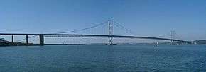 Forth Road Bridge, Edinburgh, Scotland | |
| Coordinates | 56°00′03″N 03°24′15″W / 56.00083°N 3.40417°WCoordinates: 56°00′03″N 03°24′15″W / 56.00083°N 3.40417°W |
| Carries |
|
| Crosses | Firth of Forth |
| Locale | Edinburgh and Fife, Scotland |
| Official name | Forth Road Bridge |
| Maintained by | Transport Scotland |
| Characteristics | |
| Design | Suspension bridge |
| Total length | 2,512 m (8,241 ft)[1] |
| Width | 33 m (108 ft) dual two-lane carriageway, two cycle/footpaths[1] |
| Height | 156 m (512 ft)[2] |
| Longest span | 1,006 m (3,301 ft)[1] |
| Clearance below | 44.3 m (145 ft)[1] |
| History | |
| Constructed by | Sir William Arrol & Co., Cleveland Bridge & Engineering Company and Dorman Long |
| Opened | 4 September 1964 |
| Statistics | |
| Daily traffic | 65,000 vpd (2012 figures)[3] |
| Toll | Free since 11 February 2008 |
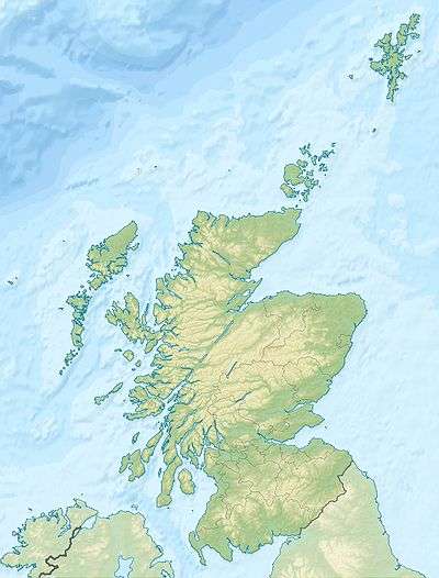 Forth Road Bridge Location in Scotland | |
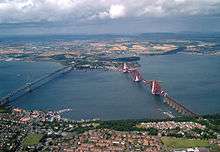
The Forth Road Bridge is a suspension bridge in east central Scotland. The bridge, opened in 1964, spans the Firth of Forth, connecting Edinburgh, at Queensferry, to Fife, at North Queensferry. It replaced a centuries-old ferry service to carry vehicular traffic, cyclists and pedestrians across the Forth; railway crossings are made by the adjacent and historic Forth Bridge.
Issues regarding the continued tolling of the bridge, and those over its deteriorating condition and proposals to have it replaced or supplemented by an additional crossing, caused it to become something of a political football for the Scottish Parliament, which voted to scrap tolls on the bridge from 11 February 2008.
On 4 December 2015, the bridge was closed to all vehicular traffic, pedestrians and cyclists due to structural issues. The bridge reopened to all traffic except heavy goods vehicles (HGVs) on 23 December 2015, and it was reopened to HGVs on 20 February 2016.[4][5][6]
History
The first crossing at what is now the site of the bridge was established in the 11th century by Margaret, queen consort of King Malcolm III, who founded a ferry service to transport religious pilgrims from Edinburgh to Dunfermline Abbey and St Andrews.[7] Its creation gave rise to the port towns of Queensferry and North Queensferry, which remain to this day; and the service remained in uninterrupted use as a passenger ferry for over eight hundred years. As early as the 1740s there were proposals for a road crossing at the site, although their viability was only considered following the construction of the Forth Bridge in 1890.[8]
The importance of the crossing to vehicular traffic was underpinned when the Great Britain road numbering scheme was drawn up in the 1920s. The planners wished the arterial A9 road to be routed across the Forth here, although the unwillingness to have a ferry crossing as part of this route led to the A90 number being assigned instead.[9]
There was a period of renewed lobbying for a road crossing in the 1920s and 1930s, at which time the only vehicle crossing was a single passenger and vehicle ferry. Sir William Denny championed the expansion of that service in the 1930s, providing and operating on behalf of the London and North Eastern Railway two additional ferries that aimed to supplement the services of the adjacent railway bridge. Their success allowed for the addition of two more craft in the 1940s and 1950s,[10] by which time the ferries were making 40,000 crossings annually, carrying 1.5 million passengers and 800,000 vehicles.
Design
With the then newest and nearest bridge spanning the Forth (the Kincardine Bridge, built in 1936) still around 15 miles (24 km) upstream, the upsurge in demand for a road crossing between Edinburgh and Fife[11] prompted the UK Government to establish the Forth Road Bridge Joint Board (FRBJB) by Act of Parliament in 1947 to oversee the implementation of a new bridge to replace the ferry service. In 1955 the authorities on either side investigated and drew up an alternative scheme for a tunnel beneath the estuary. This was known as the Maunsell Scheme, and was projected to run somewhat closer to the rail bridge than the present road bridge. The scheme was abandoned as being too ambitious and reverted to a bridge concept.[12]
Construction
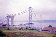
The final construction plan was accepted in February 1958 and work began in September of that year. Mott, Hay and Anderson and Freeman Fox and Partners carried out the design work and a joint venture of Sir William Arrol & Co., Cleveland Bridge & Engineering Company and Dorman Long constructed the bridge at a cost of £11.5 million, while the total cost of the project including road connections and realignments was £19.5 million. The resident design engineer was John Alexander King Hamilton FRSE (1900-1982).[13]
It was the longest steel suspension bridge in Europe.[14] 210,000 tons of concrete were involved in its construction, with nine miles of grade-separated dual-carriageway approach roads. Reed and Mallik (known for Reema construction of houses) of Salisbury, Wiltshire, built the approach viaducts.
There were twenty four individual bridges built for the approach roads. The 4.5-mile southern approach road of the A90 began at Cramond Bridge, over the River Almond on the western outskirts of Edinburgh, near Craigiehall. There were two-level interchanges built at Burnshot, Dolphington (B924) and the Echline junction (A904 and B800). At Dalmeny there was a bridge over the railway. The southern approach roads were built by A.M. Carmichael Ltd. The 4-mile northern approach road had three two-level junctions at Ferry Toll[15] (for the B980), Admiralty (for Rosyth Dockyard via the A985, and Inverkeithing via the A921) and at Mastertown/Masterton (for what would be the fledgling M90 southern terminus). The Masterton junction was an octopus junction, a variation of a clover-leaf junction, having six bridges and a 600 ft viaduct. There were fifteen bridges built for this approach road. The northern approach road terminated as the A823(M) at a roundabout with the A823 south of Dunfermline, next to Rosyth railway station.[16] The northern approach roads were built by Whatlings Ltd of Glasgow, later bought by Alfred McAlpine.
Seven lives were lost during construction before the bridge was opened by Queen Elizabeth II and the Duke of Edinburgh on 4 September 1964.[17] The ferry service was discontinued as of that date.
Operation
The bridge's management was delegated to the FRBJB, and remained so until 2002 when its operation was transferred to a new body with a wider remit, the Forth Estuary Transport Authority.[18]
On 1 December 2010 the bridge was closed for the first time due to heavy snow. After several accidents meant snowploughs were unable to clear the carriageways, the bridge was closed in both directions at 6.40 a.m. and remained closed for several hours.[19] As part of celebrations of the fiftieth anniversary of the bridge's operation, artist Kate Downie was commissioned to create a print of the bridge and hold an exhibition of works portraying it.[20]
On 1 June 2015 Amey took over the maintenance and operating of the bridge on behalf of Transport Scotland from the Forth Estuary Transport Authority and are now called the Forth Bridges Unit.
Statistics
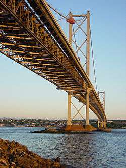
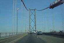
The bridge's central main span is 1,006 metres (3,301 ft) long, its two side spans are each 408 metres (1,339 ft) long, and the approach viaducts are 252 metres (827 ft) on the north side and 438 metres (1,437 ft) on the south side. At a total length of 2,512 metres (8,241 ft), it was the longest suspension bridge span outside the United States and the fourth-longest span in the world at the time of its construction. The bridge comprises 39,000 tonnes of steel and 115,000 cubic metres of concrete. The towers reach 156 metres (512 ft) above mean water level. Its width comprises a dual carriageway road with two lanes in each direction bounded by cycle/footpaths on each side. The main strung cables are 590 millimetres (23 in) in diameter, comprising 11,618 high tensile wires, each five millimetres in diameter, and each cable carries 13,800 tonnes of the bridge's load.[1][2]
The bridge forms a crucial part of the corridor between south-east and north-east Scotland, linking Edinburgh to Perth, Dundee and Aberdeen by the A90 road and its sister M90 motorway, which begins 1 2⁄3 miles (2.7 km) north of the bridge's northern terminus. The bridge carried around 2.5 million vehicles in its first year but the annual figure has risen steadily over time to around 21.4 million vehicles in 2008.[21] The bridge carried its 250 millionth vehicle in 2002.
It was awarded Historic Scotland's Category A listed structure status in 2001.
Structural issues

There has been concern at FETA over the structural wear of the bridge. The planned theoretical capacity for the bridge (30,000 vehicles per day in each direction) is routinely exceeded as traffic levels have outstripped predictions. The Scottish Government stated in 2006 that 60,000 vehicles travel on more than half the days in a year.[22] This raised concerns about the lifespan of the bridge, originally planned at 120 years.[22]
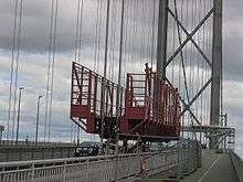
2003 saw an inspection programme launched (at a cost of £1.2 million) to assess the condition of the main suspension cables after corrosion was discovered in a number of older bridges in the United States of a similar design and size. The study, which was completed in 2005, found that the main cables had suffered an 8–10% loss of strength. Future projections highlighted the likelihood of an accelerating loss of strength, with traffic restrictions to limit loading required in 2014 in the worst-case scenario, followed by full closure by 2020.[23]
Further monitoring and remedial work is now under way. An acoustic monitoring system, commissioned in August 2006, uses listening devices to monitor any further strands snapping and pinpoint their location within the main cables.
Given the significance of the findings of the first internal inspection, in November 2005 the Scottish Executive appointed Flint & Neill Partnership to audit the results. Flint & Neill appointed New York–based Ammann & Whitney to act as sub-consultants providing specialist advice using experience gained from inspections and assessments carried out in America. In January 2006, an audit report to the Scottish Executive concluded that FETA's consultant had performed the initial internal inspection and cable strength calculation in accordance with accepted practice. The audit report suggested that traffic restrictions could be required as early as 2013.[24]
Several options are being implemented to increase the bridge's lifespan. These include an extensive dehumidification programme to slow the rate of corrosion in the main cables by installing a system that will keep the air in the voids between the strands that make up the main cables at a humidity level of below 40%. Engineering consultants Faber Maunsell began work on the project in 2006. The works are planned to take two and a half years at a cost of £7.8 million.[25] As part of the works, some of the corroded cable strands are to be spliced.[26]
The southbound carriageway of the bridge was closed on 1 December 2015 due to the discovery of steelwork defects during routine inspections.[27] Subsequently a 7.5 tonne weight limit was put in place (public service buses were not included).[28] On 4 December, the bridge was fully closed because of structural faults and was initially not expected to reopen until the new year following further inspections and repair work. Following the closure, Transport Scotland began work to lay on extra trains and buses and consider whether to reintroduce a ferry service to mitigate the impact on travellers.[29] The closure resulted in tailbacks approaching the Kincardine Bridge, the alternative route across the Forth from Fife to Edinburgh.[30] On 22 December it was announced that the Road Bridge would reopen the following day for all traffic except heavy goods vehicles (HGVs), with an expectation that the bridge will reopen to HGVs around mid-February.
On 4 February, It was announced the date had been pushed back to March for full restrictions to be taken off, due to further problems with the truss end link pins in the southern towers, which require preventative works to be carried out. Trials began to allow 600 HGVs to cross northbound between 23:00 and 04:00 each night, subject to weather conditions. The HGVs are controlled by traffic signals and released onto the bridge at a rate of one every 30 seconds.[31][32][33]
2016 public inquiry
On 20 January Scottish Parliament began its inquiry led by the Infrastructure and Capital Investment Committee (ICI), to determine the circumstances that led to the discovery of a cracked truss in the bridge's undercarriage.[34] Evidence was heard from; Forth Estuary Transport Authority (Feta), Transport minister Derek Mackay, engineers and officials from Amey along with a number of other experts and key personnel.
On the first day, Richard Hornby, of engineering consulting firm Arup, stated, since 2001, the truss end in question had been inspected 23 times and there was no fault found. It was revealed a pin had seized up, which was cause of the truss end to crack, and was only the quality of the steel which had stopped its cracking appearing earlier. Hornby also made clear even if the seized pin had been picked up earlier it was "virtually impossible" to lubricate the bearing.[35][36]
Several witnesses defended a decision by previous operator Forth Estuary Transport Authority (Feta) not to proceed with a £15 million truss end link replacement project in 2010. This claim was disputed by Barry Colford, former chief engineer and bridgemaster at the Forth Estuary Transport Authority. Lesley Hinds, Feta’s former convener, pointed out that the bridge budget had been cut by 58% in 2011, while senior staff at Feta had “deep concerns” about the transfer of bridge management to a private company.[37][38]
Tolling issues
On 11 February 2008 tolls were abolished on the bridge.[39]
Initially, it was suggested that tolling would cease once the original cost of construction plus the accrued interest was repaid – this was done in 1993 and it was planned that tolls would not be levied after May 1995. However, the legislation enabling the levying of tolls was instead renewed by Parliament (originally that of the UK but now the responsibility of the Scottish Parliament) on three separate occasions in 1998, 2003 and 2006.[40]
Originally, a toll was paid for each direction of travel with sets of toll booths on both carriageways. In 1997, a decision was made to double the northbound toll (then 40p, to 80p) and remove the southbound toll. The belief was that almost all traffic makes a return journey across the bridge, and that the removal of the southbound toll would result in a reduction of congestion for southbound traffic without reducing overall toll revenues.
The Forth Estuary Transport Authority (FETA) justified the continued use of tolls by suggesting they were necessary to fund maintenance and improvement works. These included the construction of defences around the submerged piers forming the bases of the main towers in the event of collision in the Firth. The main towers were also strengthened with internal steel columns (the original tower structure was hollow) and had hydraulic rams jack up these sections to transfer a portion of the load to the new steelwork. Also, the vertical cables suspending the deck had their bolts replaced after a single detected failure. A new paint system required development for the bridge (the original was phased out due to environmental concerns).[41]
Variable tolling proposals
| Start | End | Toll |
| 00:00 | 07:30 | £1 |
| 07:30 | 08:30 | £2 |
| 08:30 | 14:00 | £1 |
| 14:00 | 15:00 | £2 |
| 15:00 | 16:00 | £3 |
| 16:00 | 18:00 | £4 |
| 18:00 | 18:30 | £3 |
| 18:30 | 19:00 | £2 |
| 19:00 | 24:00 | £1 |
| source: Edinburgh Today | ||
In late 2005, FETA's committee approved a proposal for a complete revamp of the system of toll levies. The minimum toll would be set to the existing £1 figure, but would increase dependent on the time of day, rising to a maximum of £4 for evening rush hour travel. All tolls would be halved for cars with more than one occupant, as an incentive to drivers to share cars and make fewer journeys. According to FETA's chairman Lawrence Marshall, the system would provide the most efficiency, claiming that 80% of peak-time journeys are made by single-occupant vehicles. The proposal, passed with the chairman's casting vote after the committee was deadlocked, was referred to the Scottish Executive in December 2005, and implementation planned for October 2007 subject to approval by transport minister Tavish Scott. Environmental groups welcomed the proposal, although local politicians condemned it as simply a means of raising capital. At the same time, a counter-argument was tabled by Fife councillors proposing the complete removal of tolls.[42]
The Scottish Parliament debated the proposals in January 2006, and the affair became a major political issue after Westminster-based MPs Gordon Brown and Alistair Darling (Chancellor of the Exchequer and Secretary of State for Scotland respectively) were seen to describe the variable tolling plan as "dead in the water".[43] Scottish First Minister Jack McConnell insisted his Labour Party colleagues were misquoted and himself refused to rule out the plan, receiving considerable condemnation from the opposition Scottish National Party.[44]
The political situation was particularly important given that by late January 2006, campaigning was under way for the Dunfermline and West Fife by-election, 2006 scheduled to take place for the Westminster constituency in which the north end of the bridge is situated. The by-election, scheduled for 9 February, was contested by - in addition to the major political parties in Scotland - an Abolish Forth Bridge Tolls Party. It was won by Liberal Democrat candidate Willie Rennie, overturning a large Labour majority on a 16% swing.
In the aftermath of the by-election defeat, media speculation suggested the Executive had turned against the proposals, and Tavish Scott eventually confirmed their rejection and the retention of the existing toll structure on 1 March 2006. FETA condemned the decision, while local opposition MSPs charged the minister that his tolling review short-changed Fifers as tolls were axed on the Erskine Bridge leaving tolls on only the Forth and Tay Road Bridge.[45]
Abolition
Following the formation of an SNP minority government after the Scottish parliamentary election of May 2007, a new debate on the abolition of tolls was opened by Transport Minister Stewart Stevenson on 31 May 2007, where it was agreed by a large majority. Toll levies at that point totalled £16 million annually.[46]
The Abolition of Bridge Tolls (Scotland) Bill, required to revoke legislation mandating toll collection on the bridge, was introduced to the Scottish Parliament on 3 September 2007, passed on 20 December 2007, and received royal assent on 24 January 2008.[47] The tolls were removed on 11 February 2008 at 00:01 GMT.[48] This immediately followed a major upgrade and reconfiguration of the tolls on the northbound carriageway (the toll on the southbound carriageway had been removed some years before, simplifying the arrangement as most journeys were, and remain, two-way).[49]
Additional crossing at Queensferry
The strategic transport importance of the road bridge and the threat of closure by 2020 if major structural work were not undertaken led to fears of serious economic consequences, especially as work on any new crossing could take a decade.[50]
Increasing traffic levels across the Firth of Forth had also led to the construction of the Clackmannanshire Bridge[51] adjacent to the existing Kincardine Bridge. This bridge opened in November 2008.
Proposals for a second road crossing at Queensferry had been made in the 1990s, but were subsequently shelved, despite preliminary work on route selection. Following the discovery of potentially serious structural issues with the Forth Road Bridge in 2005 the proposals were revisited and plans advanced. The decision to proceed with a replacement bridge was taken at the end of 2007, and it was announced the following year that the existing bridge would be retained, as a public transport link. The Forth Crossing Act received Royal Assent in January 2011, and construction began in September 2011. The Queensferry Crossing is being constructed as a cable-stayed bridge, with an overall length of 1.7 miles (2.7 km). Around 2.5 miles (4.0 km) of new connecting roads are being built, including new and upgraded junctions at Ferrytoll in Fife, South Queensferry, and Junction 1a on the M9. The new bridge will continue the M90 motorway, (extending its southern terminus) from Admiralty to the M9 junction 1a (re-numbering the M9 spur).
See also
References
- 1 2 3 4 5 "Forth Road Bridge Facts and Figures". Forth Bridges Visitors Centre Trust. Retrieved 2 November 2015.
- 1 2 "FORTH ROAD BRIDGE FACTS & FIGURES". Forth Bridges Visitor Centre Trust. Archived from the original on 17 February 2012. Retrieved 11 December 2013.
- ↑ Forth Crossing Bridge Constructors (consortium). "3 Centuries of Spanning the Forth" (PDF). p. 4. Retrieved 19 October 2012.
Traffic: Each year, almost 24 million vehicles cross the bridge. Statistics show that, typically, 2% more vehicles head south than north.
- ↑ "Forth Road Bridge given green light to reopen". Retrieved 22 December 2015.
- ↑ "Forth Road Bridge to reopen on Wednesday". BBC News Scotland. Retrieved 22 December 2015.
- ↑ "Forth Road Bridge Ready to Reopen to HGVs". Retrieved 13 March 2016.
- ↑ "Queensferry History Group Newsletter". Myweb.tiscali.co.uk. 4 November 2004. Retrieved 15 January 2012.
- ↑ "History - Pre 1950". Forth Estuary Transport Authority. Archived from the original on 14 March 2008. Retrieved 7 September 2013.
- ↑ "1922 Road Lists - Roader's Digest: The SABRE Wiki". sabre-roads.org.uk. Retrieved 15 January 2012.
- ↑ "The Withdrawal of the Firth of Forth Paddle Ferries". www.megoran.fsworld.co.uk. September 2004. Archived from the original on 31 May 2010. Retrieved 7 September 2013.
- ↑ "Forth Road Bridge. Burghs Support Committee's Action". The Glasgow Herald. 27 October 1944. p. 3. Retrieved 24 November 2016.
- ↑ National Archive of Scotland ref.DD4/4300/2/8
- ↑ BIOGRAPHICAL INDEX OF FORMER FELLOWS OF THE ROYAL SOCIETY OF EDINBURGH 1783 – 2002 (PDF). The Royal Society of Edinburgh. July 2006. ISBN 0 902 198 84 X.
- ↑ Concrete Quarterly Winter 1964
- ↑ "Ferrytoll Park & Ride". Retrieved 4 December 2015.
- ↑ Pixl8 Developer. "M90. Inverkeithing to Perth and M85. Perth by-pass". Retrieved 4 December 2015.
- ↑ "The Bridge - Introduction". Forth Estuary Transport Authority. Archived from the original on 30 April 2009. Retrieved 7 September 2013.
- ↑ "New transport body for Forth road bridge". Scottish Executive. 17 January 2001. Retrieved 11 December 2013.
- ↑ Auslan Cramb (1 December 2010). "Snow closes Forth Bridge for first time". Telegraph. Retrieved 15 January 2012.
- ↑ "How Kate Downie prepared Road Bridge Diaries". Edinburgh Evening News. 16 August 2014. Retrieved 17 September 2014.
- ↑ "Traffic Statistics". Forth Estuary Transport Authority. Archived from the original on 16 May 2009. Retrieved 7 September 2013.
- 1 2 "Toll Bridges". Scottish Government. 3 July 2006. Archived from the original on 5 July 2008. Retrieved 7 September 2013.
- ↑ Colford, Barry R; Cocksedge, Charles P E. "Forth Road Bridge – First internal inspection, strength evaluation, acoustic monitoring and dehumidification of the main cables" (PDF). FETA. Archived from the original (PDF) on 18 December 2008. Retrieved 7 September 2013.
- ↑ "Audit of the Main Cable Inspection and Assessment: Final Report". The Scottish Government. 7 March 2006. Retrieved 11 December 2013.
- ↑ "FETA Forges Ahead to Tackle Corrosion". Forth Estuary Transport Authority. 1 December 2006. Archived from the original on 8 June 2013.
- ↑ "Severe corrosion found on Forth Bridge cables". ndtcabin.com. Retrieved 15 January 2012.
- ↑ "Motorists face third day of disruption due to defect on Forth Road Bridge". Herald Scotland. Retrieved 4 December 2015.
- ↑ "Weight restriction on Forth Road Bridge as traffic chaos continues". Dunfermline Press. Retrieved 4 December 2015.
- ↑ Severin Carrell. "Scotland scrambles for extra trains after Forth Road Bridge closure". the Guardian. Retrieved 4 December 2015.
- ↑ "Forth Road Bridge to be closed until new year". BBC News. 4 December 2015. Retrieved 4 December 2015.
- ↑ Full reopening of Forth Road Bridge delayed by month for HGVs - BBC News
- ↑ ‘Northbound only’ HGVs to use Forth Road Bridge at night - The Scotsman
- ↑ Weather delays full reopening of Forth Bridge as HGV trial starts | Edinburgh & East | News
- ↑ Inquiry into closure of the Forth Road Bridge to begin at Holyrood | Edinburgh & East | News
- ↑ Nutt, Kathleen (21 January 2016). "Inspections could not have detected Forth Road Bridge fault, inquiry is told". The National. Retrieved 28 August 2016.
- ↑ "Seized pin caused Forth Road Bridge fault, engineer tells Holyrood inquiry". BBC News. 20 January 2016.
- ↑ "Vital work shelved due to funding cuts, Forth Road Bridge inquiry hears". The Courier. 28 January 2016. Retrieved 28 August 2016.
- ↑ Forth Road Bridge engineers 'wanted to replace' link which broke - BBC News
- ↑ "Abolition of bridge tolls". The Scottish Government. 30 January 2008. Retrieved 8 March 2013.
- ↑ "National Alliance Against Tolls - Scotland". notolls.org.uk. Retrieved 15 January 2012.
- ↑ "Bridge Projects". Forth Estuary Transport Authority. Archived from the original on 14 August 2009. Retrieved 7 September 2013.
- ↑ "UK | Scotland | Bridge board backs £4 toll plan". BBC News. 25 November 2005. Retrieved 15 January 2012.
- ↑ "Not even an election can bridge the gap between Gordon and Jack - News". scotsman.com. 29 January 2006. Retrieved 15 January 2012.
- ↑ "UK | Scotland | Minister defiant on bridge issues". BBC News. 26 January 2006. Retrieved 15 January 2012.
- ↑ "Bridge boss furious over decision to freeze tolls - News". scotsman.com. 2 March 2006. Retrieved 15 January 2012.
- ↑ "Bridge tolls 'scrapped by the end of the year' - Politics". scotsman.com. 1 June 2007. Retrieved 15 January 2012.
- ↑ "Abolition of Bridge Tolls (Scotland) Bill" Scottish Parliament.
- ↑ "Date set for bridge tolls to be removed - Politics". scotsman.com. 30 January 2008. Retrieved 15 January 2012.
- ↑ Granted planning permission in August 2006
- ↑ "Time running out for new bridge - News". scotsman.com. 26 January 2006. Retrieved 15 January 2012.
- ↑ "UK | Scotland | Tayside and Central | Name chosen for new Forth bridge". BBC News. 1 October 2008. Retrieved 15 January 2012.
External links
| Wikimedia Commons has media related to Forth Road Bridge. |
|    | ||||||||||||||||||||||||||||||||||
|
| |||||||||||||||||||||||||||||||||||
| |||||||||||||||||||||||||||||||||||
| |||||||||||||||||||||||||||||||||||