Tregantle Fort
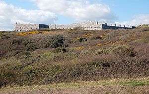


Tregantle Fort in south east Cornwall is one of several forts surrounding Plymouth that were built as a result of a decision in Lord Palmerston's premiership to deter the French from attacking naval bases on the Channel coast.
History
Tregantle Fort was completed in 1865 with barracks accommodation for 1,000 men and provision for 35 large guns.
In the event, far smaller establishments have been based there, with only six gunners in 1882. In 1893 the guns consisted of five RBL 7 inch Armstrong guns and nineteen RML 64-pounders, together with a number of SBBL 32-pounders being tested.
Early in the 1900s it became an infantry battalion headquarters with 14 officers and 423 other ranks,[1] and from 1903 was used for rifle training. Tregantle is infamous within the armed forces because many of the rifle ranges located there slope steeply down towards the sea. These ranges are still in use, primarily by personnel located at HMS Raleigh
Tregantle was vacated after World War I until 1938, when it was used as the Territorial Army Passive Air Defence School. During World War II it was used first as the Army Gas School and from 1942 as US Army accommodation.
Since 1945 it has been in use by the British Army, It is currently part of the Defence Estate.
Tregantle Fort is still used for Royal Marine training purposes. It is also used by specialist Royal Naval EW teams (FEWSG) for the monitoring of ship's communications in the area. FEWSG operate specialist coded transmission scenarios from Tregantle Fort and surrounding areas for Naval warships to decode at sea as part of an ongoing training schedule.
Tregantle Down high-angle battery
50°21′22″N 4°15′51″W / 50.356070°N 4.264291°W
A few hundred yards southeast of Tregantle Fort, along the north side of the road, there was constructed in the 1890s a battery of four 9-inch muzzle-loading guns on "high-angle" mountings. These were intended to fire shells along a high curving trajectory to more easily penetrate the decks of ships at sea to the south. Although the guns and mountings are long gone and the site is filled in, the area is clearly recognisable in aerial photographs.
Notes
- ↑ Historic England. "Details from image database (61671)". Images of England. Retrieved 2 November 2009.
External links
| Wikimedia Commons has media related to Tregantle Fort. |
- Map sources for Tregantle Fort
Coordinates: 50°21′25″N 4°16′12″W / 50.357071°N 4.270042°W