Fort Ruby
|
Fort Ruby | |
|
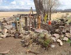
Archeological activity at Fort Ruby, c. 2000s | |
  | |
| Location | White Pine County, Nevada, USA |
|---|---|
| Nearest city | Hobson, Nevada |
| Built | 1862 |
| Architect | 3rd Infantry,California Vol. |
| NRHP Reference # | 66000460 |
| Significant dates | |
| Added to NRHP | October 15, 1966[1] |
| Designated NHL | November 5, 1961[2] |
Fort Ruby, also known as Camp Ruby, was built in 1862 by the United States Army, during the American Civil War, in the "wilderness of eastern Nevada." It protected the overland mail coaches and Pony Express, in order to maintain links and communication between residents of California and the Union. It was operated 1862 to 1869,[3] in territory dominated by bands of the Western Shoshone. The fort was located at the east entrance to the Overland Pass from Ruby Valley, near Hobson on the west side of Ruby Lake.
To secure access and safe passage through this area, as well as to provide for construction of railroads and other needs, the US signed the Treaty of Ruby Valley with twelve chiefs of the Western Shoshone, who did not cede any territory. The US also gained permission to conduct gold mining in this territory, as it needed gold in order to wage war against the Confederacy. It promised payments of annuities of $5000 annually for 20 years to the Western Shoshone, in the form of goods and livestock, but failed to make any payments after the first year.
The site, which contained several surviving log buildings, was declared a National Historic Landmark in 1961.[2][3]
Two of the four landmarked buildings on the site burned in a fire in 1992. Since the "log structures were in poor condition when this site was designated as a Landmark, and they have been altered and deteriorated significantly since designation," continued landmark status is under review by the Department of Interior.[3]
References
- ↑ National Park Service (2007-01-23). "National Register Information System". National Register of Historic Places. National Park Service.
- 1 2 "Fort Ruby". National Historic Landmark summary listing. National Park Service. Retrieved 2008-01-04.
- 1 2 3 Charles W. Snell (July 14, 1966). "National Survey of Historic Sites and Buildings: Fort Ruby" (pdf). National Park Service. and Accompanying 1 photo of Fort Ruby Cabins, exterior, from 1960 (and additional photos of unrelated Newlands Mansion, another NHL). (2.82 MB)
| Topics | |
|---|---|
| Lists by states |
|
| Lists by insular areas | |
| Lists by associated states | |
| Other areas | |
| |
Coordinates: 40°04′04″N 115°31′46″W / 40.06778°N 115.52944°W