Forsyth, Montana
| Forsyth, Montana | |
|---|---|
| City | |
|
Downtown Forsyth | |
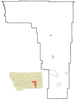 Location of Forsyth, Montana | |
| Coordinates: 46°16′0″N 106°40′40″W / 46.26667°N 106.67778°WCoordinates: 46°16′0″N 106°40′40″W / 46.26667°N 106.67778°W | |
| Country | United States |
| State | Montana |
| County | Rosebud |
| Area[1] | |
| • Total | 0.99 sq mi (2.56 km2) |
| • Land | 0.99 sq mi (2.56 km2) |
| • Water | 0 sq mi (0 km2) |
| Elevation | 2,523 ft (769 m) |
| Population (2010)[2] | |
| • Total | 1,777 |
| • Estimate (2015)[3] | 1,892 |
| • Density | 1,794.9/sq mi (693.0/km2) |
| Time zone | Mountain (MST) (UTC-7) |
| • Summer (DST) | MDT (UTC-6) |
| ZIP code | 59327 |
| Area code(s) | 406 |
| FIPS code | 30-27700 |
| GNIS feature ID | 0771501 |

Forsyth is a city in and the county seat of Rosebud County, Montana, United States.[4] The population was 1,777 at the 2010 census. Forsyth was established in 1876 as the first settlement on the Yellowstone River, and in 1882 residents named the town after General James William Forsyth[5] who commanded Fort Maginnis, Montana during the Indian Wars and the 7th Cavalry at the Wounded Knee Massacre. The town has long been a transportation nexus, starting with steamboats on the river and progressing to the Northern Pacific Railway and Interstate 94.
History
Forsyth was established as a settlement on the Yellowstone in 1876 as a steamboat landing supporting United States Army operations in the Indian Wars.[6]
in 1882, Thomas Alexander traded land to the Northern Pacific Railway to start the town, and developed four buildings on main street.[7]
In 1894, 500 men of the socialist Coxey's Army inspired by Jacob Coxey and led by William Hogan, commandeered a Northern Pacific Railway train for a trip to Washington, DC. They fought Federal Marshals on the way, and were finally apprehended in Forsyth on April 25, with the help of the Army,[8] by Troop L, Eighth Cavalry from Fort Keogh, the Cheyenne soldiers known as "Casey's scouts." This incident marked one of the few instances where Native American troops were used against whites. Although some escapes occurred, most of the Coxey's Army supporters were taken to Helena as prisoners.[9]
In the 1980s Forsyth served as the home of the United States Air Force 1st Combat Evaluation Group Detachment 18, evaluating radar observability for B-52's on training runs.[10]
Geography
Forsyth is located at 46°16′00″N 106°40′40″W / 46.266675°N 106.677684°W (46.266675, -106.677684).[11]
According to the United States Census Bureau, the city has a total area of 0.99 square miles (2.56 km2), all land.[1]
Demographics
| Historical population | |||
|---|---|---|---|
| Census | Pop. | %± | |
| 1890 | 308 | — | |
| 1910 | 1,398 | — | |
| 1920 | 1,838 | 31.5% | |
| 1930 | 1,591 | −13.4% | |
| 1940 | 1,696 | 6.6% | |
| 1950 | 1,906 | 12.4% | |
| 1960 | 2,032 | 6.6% | |
| 1970 | 1,873 | −7.8% | |
| 1980 | 2,553 | 36.3% | |
| 1990 | 2,178 | −14.7% | |
| 2000 | 1,944 | −10.7% | |
| 2010 | 1,777 | −8.6% | |
| Est. 2015 | 1,892 | [12] | 6.5% |
| U.S. Decennial Census[13] 2015 Estimate[3] | |||
2010 census
As of the census[2] of 2010, there were 1,777 people, 807 households, and 472 families residing in the city. The population density was 1,794.9 inhabitants per square mile (693.0/km2). There were 921 housing units at an average density of 930.3 per square mile (359.2/km2). The racial makeup of the city was 95.0% White, 0.5% African American, 1.6% Native American, 0.8% Asian, 0.1% Pacific Islander, 0.6% from other races, and 1.5% from two or more races. Hispanic or Latino of any race were 2.4% of the population.
There were 807 households of which 26.0% had children under the age of 18 living with them, 45.8% were married couples living together, 8.2% had a female householder with no husband present, 4.5% had a male householder with no wife present, and 41.5% were non-families. 36.6% of all households were made up of individuals and 15.8% had someone living alone who was 65 years of age or older. The average household size was 2.15 and the average family size was 2.78.
The median age in the city was 46.4 years. 22.2% of residents were under the age of 18; 6.6% were between the ages of 18 and 24; 18.9% were from 25 to 44; 32.4% were from 45 to 64; and 20% were 65 years of age or older. The gender makeup of the city was 50.1% male and 49.9% female.
2000 census
As of the census[14] of 2000, there were 1,944 people, 826 households, and 525 families residing in the city. The population density was 1,759.0 people per square mile (676.2/km2). There were 976 housing units at an average density of 883.1 per square mile (339.5/km2). The racial makeup of the city was 95.42% White, 0.21% African American, 2.26% Native American, 0.82% Asian, 0.31% from other races, and 0.98% from two or more races. Hispanic or Latino of any race were 1.23% of the population.
There were 826 households out of which 29.8% had children under the age of 18 living with them, 52.7% were married couples living together, 7.4% had a female householder with no husband present, and 36.4% were non-families. 32.9% of all households were made up of individuals and 14.4% had someone living alone who was 65 years of age or older. The average household size was 2.28 and the average family size was 2.89.
In the city the population was spread out with 25.1% under the age of 18, 5.4% from 18 to 24, 25.2% from 25 to 44, 27.0% from 45 to 64, and 17.4% who were 65 years of age or older. The median age was 42 years. For every 100 females there were 98.2 males. For every 100 females age 18 and over, there were 96.8 males.
The median income for a household in the city was $33,533, and the median income for a family was $44,100. Males had a median income of $36,827 versus $19,038 for females. The per capita income for the city was $17,994. About 9.4% of families and 10.5% of the population were below the poverty line, including 14.4% of those under age 18 and 11.4% of those age 65 or over.
Radio stations
- KIKC AM 1250 - Classic country (Forsyth)
- KIKC-FM FM 101.3 - Country Music (Forsyth)
- KATL AM 770 - Adult Contemporary (Miles City)
- KMTA AM 1050 - Oldies (Miles City)
- KYUS-FM FM 92.3 - Adult Hits (Miles City)
Notable people
- Captain William Clark led part of the Lewis and Clark Expedition through this area on the Yellowstone River in 1806
- General George Armstrong Custer led troops through this area to the Battle of Little Bighorn in 1876
- John Melcher, former U.S. senator, worked as a veterinarian in Forsyth and served as mayor in 1955.
- Carol Thurston, actress
Education
The Forsyth High School offers a variety classes and is developing capabilities under a technology plan to prepare its students for higher education. The plan has been updated frequently since 1997, and features plans for maintaining internet capability, and laboratory instrument capabilities.[15]
The Forsyth Dogies play in the 3B conference with the Baker Spartans, Colstrip Colts, Lame Deer Morningstars, Lodge Grass Indians, and St.Labre Braves. The school colors are purple and white.
References
- 1 2 "US Gazetteer files 2010". United States Census Bureau. Retrieved 2012-12-18.
- 1 2 "American FactFinder". United States Census Bureau. Retrieved 2012-12-18.
- 1 2 "Population Estimates". United States Census Bureau. Retrieved July 19, 2016.
- ↑ "Find a County". National Association of Counties. Retrieved 2011-06-07.
- ↑ "Origins of Names on Milwaukee". Roundup Record-Tribune & Winnett Times. August 22, 1940. p. 6. Retrieved 27 April 2015.
- ↑ "The Apsaalooke (Crow) Scouts". National Park Service. Retrieved 2009-11-20.
- ↑ "Forsyth, Montana". Montana: The Magazine of Western History. Retrieved 2009-11-20.
- ↑ "The Coxey Brigade Must All Go To Court" (PDF). Saint Paul Daily Globe. Retrieved 2009-11-20.
- ↑ "22nd Infantry Regiment at Fort Keogh 1888-1896". Retrieved 2012-01-27.
- ↑ "To provide for the conveyance of the Radar Bomb Scoring Site, Forsyth, Montana. S 886". Library of Congress. Retrieved 2009-11-20.
- ↑ "US Gazetteer files: 2010, 2000, and 1990". United States Census Bureau. 2011-02-12. Retrieved 2011-04-23.
- ↑ "Annual Estimates of the Resident Population for Incorporated Places: April 1, 2010 to July 1, 2015". Retrieved July 2, 2016.
- ↑ "Census of Population and Housing". Census.gov. Retrieved June 4, 2015.
- ↑ "American FactFinder". United States Census Bureau. Retrieved 2008-01-31.
- ↑ "Forsyth School Technology Development Plan". Forsyth School District. Retrieved 2008-12-09.
External links
- Official Forsyth Web Site (sponsored by local Chamber of Commerce)
- Historic Places near Forsyth
- Library of Congress Forsyth Publications
Municipalities and communities of Rosebud County, Montana, United States | ||
|---|---|---|
| Cities | 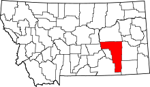 | |
| CDPs | ||
| Other unincorporated communities | ||
| Indian reservation | ||
| Ghost town | ||
| Footnotes | ‡This populated place also has portions in an adjacent county or counties | |