Forest Hills, Michigan
| Forest Hills, Michigan | |
|---|---|
| Census-designated place (CDP) & Unincorporated community | |
 | |
| Coordinates: 42°56′54″N 85°29′32″W / 42.94833°N 85.49222°WCoordinates: 42°56′54″N 85°29′32″W / 42.94833°N 85.49222°W | |
| Country | United States |
| State | Michigan |
| County | Kent |
| Area | |
| • Total | 50.8 sq mi (131.5 km2) |
| • Land | 49.4 sq mi (127.9 km2) |
| • Water | 1.4 sq mi (3.6 km2) |
| Elevation | 630 ft (192 m) |
| Population (2010) | |
| • Total | 25,867 |
| • Density | 509.2/sq mi (196.7/km2) |
| Time zone | Eastern (EST) (UTC-5) |
| • Summer (DST) | EDT (UTC-4) |
| ZIP code | 49506 |
| Area code(s) | 616 |
| FIPS code | 26-29580[1] |
| GNIS feature ID | 1867318[2] |
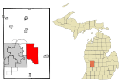
Forest Hills is an unincorporated community in Kent County in the U.S. state of Michigan. It is a census-designated place (CDP) for statistical purposes. The population was 20,942 at the 2000 census.
The Forest Hills CDP encompasses nearly all of Ada Township except the northeast corner and most of the northern half of Cascade Township.[3] The CDP includes most of the area served by the Forest Hills Public Schools District.[4]
History
Forest Hills community comprises parts of Ada Township, Cascade Township, Grand Rapids Charter Township, and Kentwood, although the statistical area of the CDP includes only portions of Ada and Cascade townships.
The Forest Hills area is most commonly associated with the Forest Hills Public Schools district which serves the area. The Forest Hills area has experienced significant growth since the 1950s when various small rural school districts were cobbled together to form a unified district, which now ranks as one of the best public school districts in the state of Michigan.
The area is known primarily as an upper-middle class bedroom community in suburban Grand Rapids.
Geography
According to the United States Census Bureau, the community has a total area of 50.8 square miles (132 km2), of which, 49.4 square miles (128 km2) of it is land and 1.4 square miles (3.6 km2) of it (2.70%) is water.
Demographics
As of the census[1] of 2000, there were 20,942 people, 7,105 households, and 6,046 families residing in the community. The population density was 424.0 per square mile (163.7/km²). There were 7,371 housing units at an average density of 149.3 per square mile (57.6/km²). The racial makeup of the community was 95.28% White, 0.64% African American, 0.20% Native American, 2.63% Asian, 0.34% from other races, and 0.91% from two or more races. Hispanic or Latino of any race were 0.95% of the population.
There were 7,105 households out of which 44.2% had children under the age of 18 living with them, 78.6% were married couples living together, 4.8% had a female householder with no husband present, and 14.9% were non-families. 12.7% of all households were made up of individuals and 4.9% had someone living alone who was 65 years of age or older. The average household size was 2.94 and the average family size was 3.23.
In the community the population was spread out with 31.4% under the age of 18, 4.9% from 18 to 24, 25.6% from 25 to 44, 29.4% from 45 to 64, and 8.8% who were 65 years of age or older. The median age was 39 years. For every 100 females there were 99.3 males. For every 100 females age 18 and over, there were 96.1 males.
The median income for a household in the community was $96,150 (2007 estimate[5]), and the median income for a family was $106,521. Males had a median income of $68,003 versus $37,553 for females. The per capita income for the community was $39,517. About 1.3% of families and 2.0% of the population were below the poverty line, including 1.7% of those under age 18 and 3.9% of those age 65 or over.
The median house value was $212,600 (year 2000)
Notable residents
- Jared Veldheer, Oakland Raiders offensive tackle[6]
References
- 1 2 "American FactFinder". United States Census Bureau. Retrieved 2008-01-31.
- ↑ "US Board on Geographic Names". United States Geological Survey. 2007-10-25. Retrieved 2008-01-31.
- ↑ Forest Hills CDP, Michigan - Reference Map - American FactFinder, U.S. Census Bureau, 2000 census
- ↑ Forest Hills Public Schools District Map
- ↑ 2005-2007 American Community Survey 3-Year Estimates, United States Census Bureau
- ↑ http://www.mlive.com/sports/grand-rapids/index.ssf/2010/04/forest_hills_northerns_jared_v.html
Municipalities and communities of Kent County, Michigan, United States | ||
|---|---|---|
| Cities | 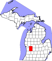 | |
| Villages | ||
| Charter townships | ||
| General law townships | ||
| CDPs | ||
| Other unincorporated communities | ||
| Footnotes | ‡This populated place also has portions in an adjacent county or counties | |