Foglia
| Foglia | |
|---|---|
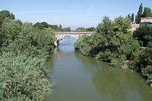 The Foglia in Pesaro | |
| Country | Italy |
| Basin | |
| Main source |
near Sestino in the province of Arezzo 980 m (3,220 ft) |
| River mouth | Adriatic Sea near Pesaro |
| Physical characteristics | |
| Length | 90 km (56 mi) |
| Discharge |
|
The Foglia is the northernmost river of the Marche region of Italy. In ancient times it was known as Pisaurus,[1] as it debouched into the Adriatic Sea at Pisaurum (modern Pesaro). It was also known as the Isaurus.[2] The source of the river is west of Sestino in the province of Arezzo (which is in the Tuscany region of Italy) in the Appennino Umbro-Marchigiano mountains.[3] It flows east through an extension of the province of Pesaro e Urbino and then back into Arezzo before forming the border between Arezzo and Pesaro e Urbino. The river then flows into the province of Pesaro e Urbino past Piandimeleto and curves northeast and flows past Sassocorvaro before curving east again. The river meanders south of Montecalvo in Foglia before curving northeast and flowing near Colbordolo, Saludecio, Sant'Angelo in Lizzola, Montecchio, Montelabbate and Tavullia before entering the Adriatic Sea near Pesaro.
Simone Cantarini painted Allegory of the Foglia River with the Coat of Arms of Pesaro
History
The river was the part of the Gothic Line and the WWII battle of Rimini.
References
- ↑ Richard J.A. Talbert, ed. (2000). Barrington Atlas of the Greek and Roman World: Map-By-Map Directory. I. Princeton, NJ and Oxford, UK: Princeton University Press. p. 611. ISBN 0691049459.
- ↑ John Lemprière, A Classical Dictionary, Containing a Copious Account of All the Proper Names Mentioned in Ancient Authors, With the Value of Coins, Weights, and Measures, Used Among the Greeks and Romans, and a Chronological Table, New Edition edited by F.D. Lemprière, London: T. Cadell, 1839, unpaginated.
- ↑ The Times Comprehensive Atlas of the World (13 ed.). London: Times Books. 2011. p. 76 N8. ISBN 9780007419135.
Coordinates: 43°55′N 12°54′E / 43.917°N 12.900°E