Fluchthorn
For the mountain in the Pennine Alps, see Fluchthorn (Pennine Alps).
| Fluchthorn | |
|---|---|
| Piz Fenga | |
|
Fluchthorn from the West, July 1987 | |
| Highest point | |
| Elevation | 3,399 m (11,152 ft) |
| Prominence | 647 m (2,123 ft) [1] |
| Isolation | 15.5 km (9.6 mi) [2] |
| Parent peak | Piz Linard |
| Coordinates | 46°53′27.2″N 10°13′38.7″E / 46.890889°N 10.227417°ECoordinates: 46°53′27.2″N 10°13′38.7″E / 46.890889°N 10.227417°E |
| Geography | |
 Fluchthorn Location in the Alps | |
| Location |
Tyrol, Austria Graubünden, Switzerland |
| Parent range | Silvretta Alps |
| Climbing | |
| First ascent | 1862 by Johann Jakob Weilenmann and Franz Pöll |
| Easiest route | Scramble |
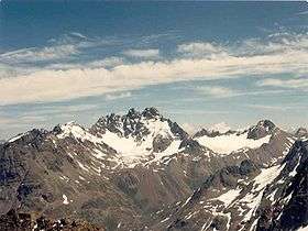
The Fluchthorn or Piz Fenga is a mountain of in the Silvretta Alps, located on the border between Austria and Switzerland. With a height of 3,399 metres (11,152 ft) above sea level, it is the second highest summit of the Silvretta Alps. The Fluchthorn lies between the Jamtal (Tyrol) and the Val Fenga (Graubünden). It consists of three summits of which the southern one is the highest.
See also
References
- ↑ Retrieved from the Swisstopo topographic maps. The key col is the Fuorcla Zadrell (2,752 m).
- ↑ Retrieved from Google Earth. The nearest point of higher elevation is north of Piz Linard.
External links
This article is issued from Wikipedia - version of the 2/15/2016. The text is available under the Creative Commons Attribution/Share Alike but additional terms may apply for the media files.