Flower's Cove
| Flower's Cove | |
|---|---|
| Town | |
 Flower's Cove Location of Flower's Cove in Newfoundland | |
| Coordinates: 51°17′0″N 56°44′0″W / 51.28333°N 56.73333°W | |
| Country |
|
| Province |
|
| Population (2006) | |
| • Total | 270 |
| Time zone | Newfoundland Time (UTC-3:30) |
| • Summer (DST) | Newfoundland Daylight (UTC-2:30) |
| Area code(s) | 709 |
Flower's Cove is a town in the Canadian province of Newfoundland and Labrador. The town had a population of 270 in the Canada 2006 Census. It is known for its thrombolite fossils.
Sights
Flower's Cove is famous for thrombolites, very rare fossils which can be seen on the coast in the southern part of the town, remnants of bacteria and algae. They are about 650 million years old. The only places where thrombolites were found are Flower's Cove and Western Australia.[1]
There are three churches in Flower's Cove, the most famous and largest of which is St. Barnabas Anglican Church. It is known as Skin Boot Church, as leather shoes were sold for the church fund when the church was built in the 1920s. Flower's Cove United Church is the smallest. It has a flèche instead of a spire.
Marjorie Bridge is a red-roofed bridge dating from the beginning of the 20th century.[2] It is close to the Roman Catholic Church Lady of Snow, which is more than 100 years old. The church was renovated in 2007. It is a part of Our Lady of Grace Parish in Bird Cove, which belongs to the diocese of St. George.
Climate
| Climate data for Flowers Cove 1981 to 2010 Canadian Climate Normals station data | |||||||||||||
|---|---|---|---|---|---|---|---|---|---|---|---|---|---|
| Month | Jan | Feb | Mar | Apr | May | Jun | Jul | Aug | Sep | Oct | Nov | Dec | Year |
| Record high °C (°F) | 12.0 (53.6) |
12.0 (53.6) |
10.0 (50) |
17.0 (62.6) |
25.0 (77) |
24.0 (75.2) |
25.0 (77) |
26.0 (78.8) |
24.5 (76.1) |
20.0 (68) |
17.0 (62.6) |
11.0 (51.8) |
26 (78.8) |
| Average high °C (°F) | −6.5 (20.3) |
−7.0 (19.4) |
−2.3 (27.9) |
2.2 (36) |
7.3 (45.1) |
12.2 (54) |
16.6 (61.9) |
17.3 (63.1) |
13.7 (56.7) |
7.7 (45.9) |
2.6 (36.7) |
−2.4 (27.7) |
5.12 (41.22) |
| Daily mean °C (°F) | −10.8 (12.6) |
−11.4 (11.5) |
−6.2 (20.8) |
−1.0 (30.2) |
3.7 (38.7) |
7.9 (46.2) |
12.5 (54.5) |
13.4 (56.1) |
9.8 (49.6) |
4.4 (39.9) |
−0.4 (31.3) |
−5.8 (21.6) |
1.34 (34.42) |
| Average low °C (°F) | −15.5 (4.1) |
−15.8 (3.6) |
−10.2 (13.6) |
−4.2 (24.4) |
0.1 (32.2) |
3.7 (38.7) |
8.4 (47.1) |
9.5 (49.1) |
5.9 (42.6) |
1.1 (34) |
−3.5 (25.7) |
−9.3 (15.3) |
−2.48 (27.53) |
| Record low °C (°F) | −30.0 (−22) |
−34.0 (−29.2) |
−31.0 (−23.8) |
−21.0 (−5.8) |
−9.0 (15.8) |
−4.0 (24.8) |
−1.0 (30.2) |
2.0 (35.6) |
−2.0 (28.4) |
−9.0 (15.8) |
−18.0 (−0.4) |
−29.0 (−20.2) |
−34 (−29.2) |
| Average precipitation mm (inches) | 87.9 (3.461) |
70.8 (2.787) |
71.9 (2.831) |
56.4 (2.22) |
76.1 (2.996) |
106.5 (4.193) |
107.6 (4.236) |
102.3 (4.028) |
99.2 (3.906) |
96.5 (3.799) |
79.3 (3.122) |
84.7 (3.335) |
1,039.2 (40.914) |
| Average rainfall mm (inches) | 16.0 (0.63) |
12.4 (0.488) |
21.8 (0.858) |
31.0 (1.22) |
70.4 (2.772) |
105.9 (4.169) |
107.6 (4.236) |
102.3 (4.028) |
99.2 (3.906) |
94.0 (3.701) |
65.6 (2.583) |
36.6 (1.441) |
762.8 (30.032) |
| Average snowfall cm (inches) | 72 (28.3) |
58 (22.8) |
50 (19.7) |
25 (9.8) |
6 (2.4) |
1 (0.4) |
0 (0) |
0 (0) |
0 (0) |
3 (1.2) |
14 (5.5) |
48 (18.9) |
277 (109) |
| Average precipitation days (≥ 0.2 mm) | 13.2 | 12.4 | 11.4 | 11.2 | 12.7 | 15.1 | 15.1 | 14.6 | 14.6 | 15.5 | 14.3 | 13.8 | 163.9 |
| Average rainy days (≥ 0.2 mm) | 2.4 | 2.5 | 3.6 | 6.3 | 11.7 | 15.0 | 15.1 | 14.6 | 14.6 | 15.2 | 10.1 | 4.3 | 115.4 |
| Average snowy days (≥ 0.2 cm) | 11.7 | 10.6 | 8.3 | 4.9 | 1.0 | 0.13 | 0 | 0 | 0 | 0.48 | 3.9 | 9.5 | 50.51 |
| Source: Environment Canada[3] | |||||||||||||
Images
 General view of the town
 Thrombolites
 St. Barnabas Anglican Church
 St. Barnabas Anglican Church
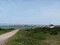 United Church
 Marjorie Bridge
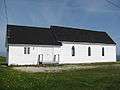 Catholic Church Lady of Snow
 Catholic Church Lady of Snow
References
- ↑ Andrew Hampstead: Atlantic Canada, p. 380. Berkeley CA 2012.
- ↑ Andrew Hampstead: Atlantic Canada, p. 379. Berkeley CA 2012.
- ↑ http://climate.weather.gc.ca/climate_normals/results_1981_2010_e.html?stnID=6624&lang=e&province=NL&provSubmit=go&dCode=0
See also
Coordinates: 51°17′57.42″N 56°43′42.39″W / 51.2992833°N 56.7284417°W