Fiskerton, Lincolnshire
| Fiskerton | |
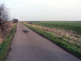
 Five Mile Bridge across the Witham |
|
 Fiskerton |
|
| Population | 1,209 (2011) |
|---|---|
| OS grid reference | TF050720 |
| – London | 120 mi (190 km) S |
| District | West Lindsey |
| Shire county | Lincolnshire |
| Region | East Midlands |
| Country | England |
| Sovereign state | United Kingdom |
| Post town | Lincoln |
| Postcode district | LN3 |
| Dialling code | 01522 |
| Police | Lincolnshire |
| Fire | Lincolnshire |
| Ambulance | East Midlands |
| EU Parliament | East Midlands |
| UK Parliament | West Lindsey |
|
|
Coordinates: 53°14′06″N 0°25′42″W / 53.2351°N 0.42829°W
Fiskerton is a small commuter village and civil parish in the West Lindsey district of Lincolnshire, England. The population of the civil parish at the 2011 census was 1,209.[1] It is situated approximately 6 miles (10 km) east from the city and county town of Lincoln, and on the north side of the River Witham.
History
Fiskerton Grade I listed Anglican parish church, which stands at the side of the main road through the village, is dedicated to St Clement. It dates from the 11th century, and was restored in 1863.[2] The arcade of the north aisle is Norman; that of the south aisle, Early English. The Perpendicular-style tower is square, but encloses an earlier round tower.[3] Cox reports in 1916 that a brass effigy of a priest (c. 1485) in the south aisle was restored to the church by Bishop Trollope in 1863, having been found in a Lincoln dealer's shop.[3] A Wesleyan Methodist chapel was built in the village in 1839.[4]
Fiskerton has received international archaeological attention on a number of occasions over the last two centuries following discoveries of Iron Age artefacts buried in the fenland peat that surrounds the village. In 1826 a fine, metre-long decorative shield was discovered in the River Witham, near Washingborough.[5] Now known as the Witham Shield it has been dated to the second century BC (200–100 BC) and is in the British Museum.[6][7]
Over 150 years later when a dyke was being cleaned, a series of posts were found together with an early to mid-Iron Age sword. Subsequent excavations in 1981 revealed the posts to be a wooden causeway which dendrologists dated to a period between 457 and 300 BC. It appeared to have been repaired and added to every eighteen years or so during that period and the construction and maintenance of a walkway on such a scale at that time would have been a major feat of engineering. Hundreds of artefacts were also found around the causeway, including eleven spears, six swords, woodworking and metalworking tools, as well as part of a human skull which had a crescent-shaped chop mark, probably inflicted by a sword; this injury is unlikely to have killed the man.[8] It is possible that the Witham Shield was originally deposited beside this causeway.[6]
Twenty years later in further excavations more sections of the causeway were dug out, some of them containing posts several metres long, plus a complete spear, a currency bar, a sword, a dagger and some bronze fittings, all of which appeared to have been deliberately damaged before their burial.[9] The most important discovery was two votive Iron Age boats. One of these boats as well as other artefacts can be seen at The Collection in Lincoln. The area around the site of the causeway, which is alongside the road to Short Ferry, (a hamlet 1.6 miles [2.5 km] to the east) opened as a nature reserve managed by the Lincolnshire Wildlife Trust in 2006.
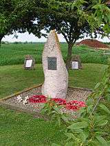
During the Second World War, an airfield was built on agricultural land to the north of the village. RAF Fiskerton opened in January 1943 as part of 5 Group, RAF Bomber Command as 52 Sub-Base Station controlled by RAF Scampton. It closed at the end of the war in September 1945 and the land returned to agricultural use. Very little can be seen of the old airfield now, but a memorial to No. 49 Squadron RAF and 576 Squadron, who were stationed at the airfield during the war, can be found by the side of the road between Fiskerton and Reepham, a village 1.5 miles (2.4 km) to the north. [10]
References
- ↑ "Civil Parish population 2011". Neighbourhood Statistics. Office for National Statistics. Retrieved 17 May 2016.
- ↑ Historic England. "Church of St Clement (1064020)". National Heritage List for England. Retrieved 29 July 2011.
- 1 2 Cox, J. Charles (1916) Lincolnshire p. 249; Methuen & Co. Ltd
- ↑ Kelly's Directory of Lincolnshire with the port of Hull 1885, p. 394
- ↑ Stead, Ian, 1985, 1996. Celtic Art. British Museum Press. Chapter 5, Weapons and armour, p 72.
- 1 2 Pryor, Francis, 2003. Britain BC: Life in Britain and Ireland before the Romans. HarperCollinsPublishers. London. Chapter 12, Glimpses of Vanished Ways (the later Iron Age: 200 BC—AD 43, and After), p 408.
- ↑ Pryor, Francis, 2004. Britain AD: A Quest for Arthur, England and the Anglo-Saxons. HarperCollinsPublishers. London. Chapter 8, The Making of the English Landscape, p 218.
- ↑ Field, Naomi and Pearson, Mike Parker, 2003. Fiskerton: An Iron Age Timber Causeway with Iron Age and Roman Votive Offerings, Oxbow Books, Oxford
- ↑ Kennedy, Anra. "Treasures of the Celtic Causeway - The Fiskerton Log Boat", Culture24, 26 March 2002. Accessed 24 November 2009
- ↑ Historic England. "Fiskerton Airfield] (1395431)". PastScape. Retrieved 4 August 2010.
External links
 Media related to Fiskerton, Lincolnshire at Wikimedia Commons
- Fiskerton in the Domesday Book
England Portal | |
| Unitary authorities | |
| Boroughs or districts | |
| Major settlements |
|
| Topics | |