Fergushill
Fergushill is a small community in North Ayrshire, Parish of Kilwinning, Scotland. The Barony of Fergushill was held by the Fergushill family of that Ilk and the area has a complex history.
History
The Fergushills of that Ilk
The area is either named after the family of this name, Fergushill of that Ilk, or more likely, the family took the name of the area as their patronym, as with the Cunninghame clan. Robert de Fergushill de Eodem had an extensive estate here in 1417. Robert Fergushill died in the late 17th-century and was the last of the family to be local lairds. The expression 'de Eodem' refers to the patronym being the same name as the barony.
Robert Fergushill is shown in a charter from Robert Hunter of Hunterston to have a share in the 46s 8d land of Annanhill-Hunter, however William Henry Dunlop remained the proprietor.[1]
In the 17th-century it was the custom in respectable families for the names of the principal friends present to be entered into the baptismal register. Mr. Baillie of Monkton's register had the names Fergushill, Ashinyards and Muncardine entered.[2]
The Laird of Fergushill in the early 18th century was amongst a number of local lairds who ordered the bailies of Kilmarnock to proceed with the causewaying of the streets. A very early example of road improvements in Ayrshire.[3]
In 1577 A. Fergushill was a burgess of Ayr and sold the lands of Gallisholmes to John Wallace of Craigie.[3]
John Fergushill (1592–1644) was a covenanter minister and martyr who is remembered by a monument erected at Fenwick kirk.[4][5]
Fergushill as a surname is a sept of the Clan Fergusson.
In 1605 Patrick Lowrie was convicted of being a warlock and sentenced to be strangled and then burned at the stake in Edinburgh. One of Lowrie's crimes was stated as being for art and part of the Bewitching of certain milk kye, pertaining to Johnne Fergushill, younger, in Halie, at Beltane 1604 years; whereby the kye gave no milk but blood and worsome (purlent) therafter.[6]
In 1671 David Fergushill went to the Corsehill Barony Court to obtain payment for a boill bear from one Thomas Wylie of Little Corsehill.[7]
In 1691 the 'House of Fergushill' itself had seven hearths listed in the Hearth Tax records and eighteen other properties within the barony.[8]
In 1697 John Crawfurd, son of Alexander Crawfurd of Fergushill, purchased the estate of Kersland near Kilbirnie and took the name and title of John Ker of Kersland; he died in 1723 after an eventful life and the loss of his estates.[9]
Fergushill House and other properties of that name
Alexander Craufurd of Fergushill inherited the property from his father and it next passed by inheritance to the Kincaid family who alienated the lands to Neil Macvicar and his wife Elizabeth Montgomerie in 1728. The Macvicars retained the lands until 1802 when they were acquired by Robert Glasgow of Montgreenan.[3]
A number of properties in the surrounding area have the appellation Fergushill, such as at Knockentiber; North & South Fergushills near Eglinton, also Hill and Hall of Fergushill at Auchentiber. Robert Fergushill of Fergushill had a crown charter in 1633 of the lands of Middle Auchentiber.
Ness[10] records that Fergushill was at its height in around 1560 and that it and its coal pits finally became a pendicle of Eglinton in 1799. The old house itself stood about 75 yards (69 m) to the east of the 'Elbo and chael' bridges as the old horse tramway and road bridges seem to have been known locally. In the late 1960s all that remained of the old house were a few low walls.
Townhead of Fulwood belonged to James Fergushill, disposed to him by Alexander Dunlop of that Ilk in 1687. The family held it until about 1750, when William Mackie of Mosside obtained it.[1]
Robertson in 1823 records that The mansion of Fergushill appears now as a commodious farm house, covered with thatch: but its ancient gardens, pretty well stored with plum and other fruit trees, indicate its former rank.[11] Aerial photographs and observations on the ground show the ditch, dyke and coppiced trees which may have been the boundary between the two baronies.[12]
The old house stood on the north side of the Lugton Water[13] and in 1799 it became the property of the 12th Earl of Eglinton and Winton, it was still described as A good mansion, surrounded by some fine old trees, render the place still worthy of being inhabited by ane honest and descreit gentleman.[14] Robin Cummell records that the Fergushill miners were sold with the land, a normal practice for the time.[15] In 1775 Andrew Armstrong's, A new map of Ayrshire... shows the mansion and wooded policies of Fergushill.
Davis records the existence of a disused driveway at Fergushill with a demolished gate-lodge; he goes on to record that the ruins of a small house are to be found in vicinity of the farm buildings.[13][16] Fergushill House stood near the Lugton Water, close to South Fergushill Farm and the present day Fergushill cottage. As stated, the Chapelholms woodlands still contain a network of banks and ditches with lime tree plantings which may represent the march dyke between the Fergushill and Eglinton lands or the woodland / pasture boundary.
In 1803 George Reid of Barquharry, a good friend of Robert Burns,[17] was Factor to the Earl of Eglinton and used Fergushill House as his residence. Robin Cummell (Campbell) who worked at Eglinton Castle[18] records that Reid was very fond of entertaining his many friends at Fergushill.
Byla Greenshields was a particularly interesting character and wore yellow buckskin trousers and white shoes to his dinners at Fergushill. The usual invitation was - Dear Byla, The leather breeks and taps buits on Thursday.[15] Cummell also records the place name Chapel Bridge at Fergushill for what is now known as the Diamond Bridge.[19]
The Darien Affair
The Darien Company was an attempt by the Scots to set up a trading colony in America in the late 1690s, however the opposition from England and elsewhere was so great that the attempt failed with huge losses and great financial implications for the country and for individuals. Half of the whole circulating capital of Scotland was subscribed and mostly lost. In Cunninghame some examples of losses are John Craufurd of Fergushill (£1000), Hugh Stevenson of Mongtreenan (£1000), and Sir William Cunninghame of Cunninghamhead (£1000). In modern terms a thousand pounds loss in the 17th century must have been a devastating blow even to the finances of great landowning families.[14]
Fergushill church
Fergushill church in Benslie was built to serve the local rural and mining communities of Doura, Fergushill, and Montgreenan.[20] It was consecrated on Sunday, 3 November 1879 and the first minister was then Rev. William McAlpine.[21] It got its name from the Fergushill Mission which was based at Fergushill school, which was closed in 1950.[22] The church had its spire blown down in a gale in 1968, also damaging the roof; the building was repaired in 1969.[10] By the mid-1970s, the church was linked to the Erskine Church of Scotland in Kilwinning, and services were led by Erskine's minister, the Rev. Rudolf Dehn, who had been a nuclear scientist at Dounreay before going into the ministry; several young people from the Fergushill area joined Erskine Church's youth group at this time.[23] The Church of Scotland Presbytery of Ardrossan decided to close the church in June 2009; over a hundred people attended the final Sunday service.[24]
Views of Fergushill church and manse
 The old Fergushill church at Benslie.
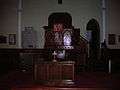 The interior.
 Memorial to William MacAlpine.
 Janburrow, Fergushill church's old manse and previously the G&SWR company agent's office near Montgreenan.[25]
The rural community


Fergushill Cottage faced the Lugton Water just below the point at which the Fergushill Burn joins the river. Nothing much remains, however a Mrs. Miller once lived here and she recollected collecting water from the well which still exists as a circular low brick wall near to the site. In 1881 the Census records that a Minister, Mr. William McAnespin lived here, together with his sister Jannette McAnespin and a servant Marion Mackay. A weir still exists on the Lugton Water near here and this was the site of a drowning in the 1990s. Saughtrees on the Eglinton estate side of the road was a gamekeepers cottage in 1837.[26]
In 1814 a flour mill was located on the Eglinton Castle side of the Lugton Water upstream of the bridge and a miller's house was situated on the other side of the river. The building of the waggonway and bridge seems to have resulted in the demolition of this house. A path ran from it to a plantation next to the river.[27]
Sevenacres Mill is fairly close by. It is known by the locals as 'Snakers Mill.' A small estate existed near here in the 1560s, held by William Montgomery, said to be descended from the Montgomerys of Smithstone.[28]


Saugh Trees cottage sits close to the old waggonway bridge and a cottage by the unusual name of 'Redboiler' used to sit road junction up to Seven Acres. Red Boiler had a number of large metal boiler vessels, used for steam generation at the coal mines, that were brought down from the mines for cleaning and scouring at this site.[29]
John Thomson's Atlas of Scotland, 1832, marks a 'Baker's Mill' on the Lugton Water, possibly explaining the presence of the surviving weir.[30] Both may also relate to the old barony mill.
Fergushill had a Mission Hall from circa 1890 to 1936; it also served Benslie. The hall was dismantled and rebuilt at the Dirrans. Glass slides bearing choruses and verses used at the Mission Hall are now held by the Kilwinning Abbey Heritage Centre.[31]
The patches of ash / elm woodland running up to Seven Acres Mill are amongst the very few remaining ancient woodlands in the Irvine area with mainly indigenous species and a continuous history of woodland cover.[32]
The school
Fergushill school house still exists, however the school, which sat on the road up to Broomhill and North Fergushill farms has been demolished. This school was a replacement for the older school which had existed at the 'High Row' close to the railway.[33]
The Industrial past
John Smith in 1895 records the remains of an old lade , which supplied water to drive a wheel wherewith the old coal-pits used to be drained.[34] A relatively early example of the use of such technology.


In 1874 Dobie records that a miner's village called Fergushill existed with a population of 531.[35] Groome refers to the colliers village as having been established in around 1835.[36]
Fergushill miners' village, was owned by Messrs. Finnie & Son. It was composed of 7 rows of cottages. There were ten thatched cottages. In 1913 63 persons lived here. One room, measuring 9 feet (2.7 m) by 6 feet (1.8 m), held thirteen persons. The rows had names like Wellington and Burn. At one time there were 78 houses in the village, with a population of 363.[37] It was demolished and nothing now remains at the site, other than North Fergushill farm.
A horse drawn tramway, opened in 1834, which ran up to Fergushill and Doura, ending at the coal pit.[12] The old waggonway bridge across the Lugton Water still stands.
Fergushill Tile Works existed in 1858, but is not shown on the 1897 OS map. A number of freight lines have run through the village, connecting the main line near Montgreenan with the Doura branch.
One of the Fergushill collieries stood near the Chapel gate cottage (no longer present) of the Eglinton castle estate; the mine bing still survives amongst a screen of secondary woodland. In 1929 Fergushill Pit No. 23 & 28 were known as the 'Happy Home' and No. 7 was called 'The Rover.'[38] The Statistical Account records that the coals at Doura were main and stone-coals. Laigh Fergus-hill (sic) mine was owned by Mr McDowal and was leased by him for £100 per annum in the 18th century. A great quantity of coal had at one time been exported through Irvine to Ireland. Eglinton Colliery was flooded for some years after miners broke into an old waste at Fergushill in November 1747. The early mines were laid up in the 1790s.[39]
A William Forgisal (Fergushill) of Torranyard was miner at the Doura Pit in the 18th-century. He lost his leg in a mining accident, as had his father. William's wife was a tough sort, her comment being on seeing him so encumbered, was that the Forgisal's would need a small plantation of their own to keep them in crutches.[15]
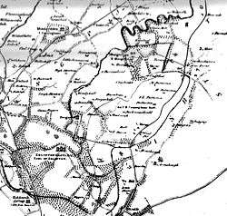
The Ardrossan and Johnstone Railway - Fergushill branch

This line began life as a waggonway which opened in 1831 between Ardrossan and Kilwinning and was known as the Ardrossan and Johnstone Railway.[40] It was initially built to the Scotch gauge of 4 ft 6 in (1,372 mm) and was worked by horses.[41] It had a passenger services worked by a carriages, which held 24 passengers; 16 inside and 8 outside.[41] The railway was built by the Glasgow, Paisley and Johnstone Canal company. It commenced on the west side of Ardrossan harbour. The 3-mile (4.8 km) long Doura branch left the main line near Stevenston and crossed under the Glasgow, Paisley, Kilmarnock and Ayr Railway to reach the Doura coal pit.[40][41] The 0.5-mile (0.80 km) North Fergus Hill branch left the Doura branch at South Fergushill, just after the Lugton Water crossing to reach the Fergus Hill coal pit.[40][41] Crossing gates were located at Dirrans, Corsehill, Saughtrees and Fergushill. Clonbeith siding was located near the Fergushill gates.[38] The Fergushill drive entrance into the Eglinton Estate passed Chapelholm Woods was carried over the railway by a bridge; this has since been demolished.[42]
The line would have been involved in the transportation of visitors to the famous Eglinton Tournament of 1839.[43] The section beyond the terminus station at Dirrens was for coal, however the Earl seems to have had a private station at Millburn. The ruins of Millburn station are still extant. Between 28 July 1834 and September 1835 over 21,000 people had been carried on the railway using the regular passenger service. By the late 1830s the annual figure was around 30,000.
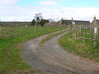
 Mill Cottages, South Fergushill and the Chapelholme Drive to Eglinton Country Park.
 The old Fergushill school house.
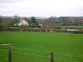 Fergushill cottage looking towards Kilwinning.
 The 19th-century waggonway bridge (foreground) over the Lugton Water near Fergushill farm.
 The Fergushill Burn where it joins the Lugton Water.
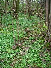
 The old well in the woods near Fergushill cottage.
 The ruins of old Fergushill Cottage.
 The ruins of old Fergushill Cottage and its garden remnants.
Fergushill tileworks

These tileworks was built in 1831 at North Fergushill farm and consisted of a moulding room, kiln and drying stores. The tileworks were in a field just to the east of an unclassified road between North Fergushill farm and the old Dalry to Kilmarnock railway line. The first manager of the Tilework appears to be a Hugh Bunton or Buntine. Bunton probably lived at the adjacent Tilework Cottage. From September 1836 to the end of 1837 the Eglinton Estate purchased between 5,000 and 10,000 tiles per month for use on its farms.[44]
The fate of the tileworks is revealed in the memoranda from George Johnston, the Earl of Eglinton’s factor, to the Earl’s Commissioner, Mr Gairdner. By the end of 1852 demand for tiles had fallen considerably, production however was not reduced. George Johnston noted there were 480,000 unsold tiles stored at Fergushill and there was no room for the next year’s stock. The 1855 OS map notes the tilework is disused. The old clay pit site is now a large pond, and Tilework Cottage is a privately owned house.[44][45]
See also
References
- Notes
- 1 2 Dobie, James (1876). Pont's Cunninghame topographized 1604-1608 with continuations and illustrative notices (1876). Pub. John Tweed. P. 69.
- ↑ Robertson, George (1823). A Genealogical Account of the Principal Families in Ayrshire, more particularly in Cunninghame. Pub. Cunninghame Press. Irvine. P. 27.
- 1 2 3 Paterson, James (1866) History of the Counties of Ayr and Wigton. Vol. III - Cuninghame. Edinburgh : James Stillie. P. 374.
- ↑ Macintosh, John (1894) Ayrshire Nights' Entertainments. pub. Dunlop & Drennan. Kilmarnock. P. 268.
- ↑ Biography of John Fergushill.
- ↑ Mackintosh, Ian M. (1969), Old Troon and District. Pub. George Outram, Kilmarnock. P. 61.
- ↑ Corshill Baron-Court book Archaeological & Historical Collections relating to Ayr & Wigton. 1884. Vol. IV. Pub. Ayr & Wigton Arch Assoc. P. 100.
- ↑ Urquhart, Page 92
- ↑ Paterson, James (1863-66). History of the Counties of Ayr and Wigton. V. 3. Parts 1 & 2. p. 183. Edinburgh: J. Stillie.
- 1 2 Ness, J. A. (1969 - 70). Landmarks of Kilwynnyng. Privately produced.
- ↑ Robertson, George (1823). A Genealogical Account of the Principal Families in Ayrshire, more particularly in Cunninghame. Pub. Cunninghame Press. Irvine. P. 212.
- 1 2 Eglinton Country Park archive.
- 1 2 Scottish National Archive. RHP 2043.
- 1 2 Dobie, James (1876). Pont's Cunninghame topographized 1604-1608 with continuations and illustrative notices (1876). Pub. John Tweed. P. 140.
- 1 2 3 Service, John (1913), The Memorables of Robin Cummell Paisley : Alexander Gardner. p. 191.
- ↑ Davis, Michael (1991), The Castles and Mansions of Ayrshire. Pub. Privately by M.Davis. P. 261.
- ↑ Reid of Barquharry
- ↑ Boyle, A. M. (1996), The Ayrshire Book of Burns-Lore. Darvel : Alloway Publishing. ISBN 0-907526-71-3 p. 67.
- ↑ Service, John (1913), The Memorables of Robin Cummell Paisley : Alexander Gardner. p. 190.
- ↑ Fergushill Church
- ↑ Ker, Rev. William Lee (1900) Kilwinnning. Pub. A.W.Cross, Kilwinning. P. 153.
- ↑ Ker, Rev. William Lee (1900) Kilwinnning. Pub. A.W.Cross, Kilwinning. P. 151.
- ↑ Back, Phil, joint leader Erskine Church Youth Group.
- ↑ Kilwinning Adveertiser, Irvine Times, June 2009
- ↑ Hawksworth, Chris. Montgreenan Station. Sou-West Journal. 2008 - 2009. No. 40. p. 14.
- ↑ Scottish National Archive. RHP 47762.
- ↑ Scottish National Archive. RHP 2038.
- ↑ Ness, John (1990). Kilwinning Encyclopedia. Kilwinning and District Preservation Society. p.64
- ↑ Thomson (2009), oral communication. Local resident.
- ↑ Maps at the National Library of Scotland. John Thomson's Map
- ↑ Irvine Times, 21-07-2010, Page 7
- ↑ Weyl, Richard. Wildlife Survey of Irvine New Town. NCC and IDC. Pages 6 & 7
- ↑ OS Town maps
- ↑ Smith, John (1895) Prehistoric Man in Ayrshire. Pub. Elliot Stock. London. P. 61.
- ↑ Dobie, James (1876). Pont's Cunninghame topographized 1604-1608 with continuations and illustrative notices (1876). Pub. John Tweed. P. 150.
- ↑ Groome, Francis H. (1903). Ordnance Gazetteer of Scotland. Pub. Caxton. London. P. 574.
- ↑ Fergushill Miner's Rows
- 1 2 Scottish National Archive. GD1/905/78.
- ↑ Duckham, Baron Frederick (1970). A History of the Scottish Coal Industry - Volume 1: 1700-1815. A Social and Industrial History. Newton Abbot : David & Charles. ISBN 0-7153-4886-8 / . Page 157.
- 1 2 3 Lewin, Henry Grote (1925). Early British Railways. A short history of their origin & development 1801-1844. London: The Locomotive Publishing Co Ltd. OCLC 11064369. P. 17 - 18
- 1 2 3 4 Whishaw, Francis [1842] (Reprinted and republished 1969). The Railways of Great Britain and Ireland practically described and illustrated, 2nd, Newton Abbott: David & Charles (1842 edition - London: John Weale). ISBN 0-7153-4786-1.
- ↑ National Archives of Scotland. RHP/34800/1-3.
- ↑ Anstruther, Ian. (1963),"The Knight and the Umbrella: An Account of the Eglinton Tournament — 1839", Geoffrey Bles Ltd, London.
- 1 2 AYRSHIRE NOTES 32, 2006, ISSN 1474-3531. pages 21 - 24.
- ↑ Ayrshire Notes
- Sources
- Urquhart, Robert H. et al. (1998). The Hearth Tax for Ayrshire 1691. Ayrshire Records Series V.1. Ayr : Ayr Fed Hist Soc ISBN 0-9532055-0-9.
External links
| Wikimedia Commons has media related to Fergushill. |
Coordinates: 55°39′21.5″N 4°39′11.1″W / 55.655972°N 4.653083°W