Fehérgyarmat
| Fehérgyarmat | ||
|---|---|---|
|
Aerial photo: Fehérgyarmat Church | ||
| ||
 Fehérgyarmat | ||
| Coordinates: 47°59′06″N 22°31′02″E / 47.98500°N 22.51722°E | ||
| Country |
| |
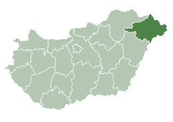
| County | Szabolcs-Szatmár-Bereg | |
| Area | ||
| • Total | 52.46 km2 (20.25 sq mi) | |
| Population (2015) | ||
| • Total | 8,089[1] | |
| • Density | 154.3/km2 (400/sq mi) | |
| Time zone | CET (UTC+1) | |
| • Summer (DST) | CEST (UTC+2) | |
| Postal code | 4900 | |
| Area code(s) | 44 | |


Fehérgyarmat is a town in Szabolcs-Szatmár-Bereg county, in the Northern Great Plain region of eastern Hungary.
Geography
It covers an area of 52.46 km2 (20 sq mi) and has a population of 8089 people (2015).[1]
Twin towns — Sister cities
Fehérgyarmat is twinned with:
-
 Nisko in Poland
 -
 Vynohradiv in Ukraine
References
- 1 2 Gazetteer of Hungary, 1st January 2015. Hungarian Central Statistical Office. 03/09/2015
Coordinates: 47°59′N 22°31′E / 47.983°N 22.517°E
This article is issued from Wikipedia - version of the 5/15/2016. The text is available under the Creative Commons Attribution/Share Alike but additional terms may apply for the media files.