Farmington River
| Farmington River | |
| River | |
 Looking downstream on the Farmington River in Simsbury, Connecticut | |
| Country | United States |
|---|---|
| State | Massachusetts & Connecticut |
| Primary source | outlet of Hayden Pond (West Branch of the Farmington River) [1] |
| - location | Otis, Berkshire County, Massachusetts |
| Secondary source | Barkhamsted Reservoir (East Branch of the Farmington River) [2] |
| - location | Hartland, Hartford County, Connecticut |
| Source confluence | confluence of the East Branch and West Branch |
| - location | New Hartford, Litchfield County, Connecticut |
| Mouth | confluence with Connecticut River |
| - location | Windsor, Hartford County, Connecticut |
| - coordinates | 41°50′37.3596″N 72°37′52.6368″W / 41.843711000°N 72.631288000°WCoordinates: 41°50′37.3596″N 72°37′52.6368″W / 41.843711000°N 72.631288000°W |
| Length | 80.4 mi (129 km), from source of West Branch |
| Basin | 602 sq mi (1,559 km2) |
The Farmington River is a river, 46.7 miles (75.2 km)[3] in length along its main stem, which is located in northwest Connecticut with major tributaries extending into southwest Massachusetts. Via its longest branch (the West Branch), the Farmington's length increases to 80.4 miles (129.4 km), making it the Connecticut River's longest tributary by a mere 2.3 miles (3.7 km) over the major river directly to its north, the Westfield River.[3] The Farmington River's watershed covers 609 square miles (1,580 km2). The river historically played an important role in small-scale manufacturing in towns along its course, but it is now mainly used for recreation and drinking water. The Farmington River Watershed Association[4] is a non-profit organization for conservation and preservation of this river.
Headwaters for both main branches of the Farmington River, referred to as the East Branch and West Branch, are found in southwestern Massachusetts, though only the West Branch officially begins north of the Connecticut border. The West Branch rises at the outlet of Hayden Pond in Otis, Massachusetts. In 1994, a 14-mile (23 km) stretch of the branch was designated a National Wild and Scenic River.[5] The East Branch begins in Hartland, Connecticut at the confluence of Pond, Hubbard and Valley Brooks.[1] However, this branch has been impounded along the first 11 miles of its course to form the Barkhamsted Reservoir and Lake McDonough; it does not assume a particularly river-like appearance until it exits Lake McDonough in New Hartford, Connecticut. The East Branch and West Branch join in New Hartford, Connecticut just about one mile south of Lake McDonough. Upper reaches of the river flow mostly southward, but the river turns northward in Farmington, Connecticut and then runs mostly north and east until it flows into the Connecticut River near the Loomis Chaffee School in Windsor, Connecticut.
Boating
There are several whitewater sections.[6][7] One of these, the so-called "Upper Farmington" section of the West Branch in New Boston, Massachusetts, is about 7 miles (11 km) long. It is Class 2 through farm and woods scenery to an iron bridge, where kayak and canoe slalom races are held. Below the bridge the river becomes Class 3-4, very technical at low water, and technical and pushy at higher water, with a short gorge with several abrupt drops.

The biggest of these is about four feet at Decoration Rock. Below, the river continues fast and technical with many rocks and constant maneuvering required. The river is continuously rapid, leading through larger drops at Battering Ram rapid and Corkscrew. Eventually it flattens to Class 2 until a final, ledge rapid at Bear's Den, just above the reservoir. The Upper Farmington is barely runnable (very scratchy with many exposed rocks and pinning possibilities) during fall dam releases, and is a much better run at levels of about 600 cubic feet per second (16,990 l/s), or about 5 feet (1.5 m) on the internet gauge for that section.
A second whitewater section is found in Tariffville, Connecticut, one mile (1.6 km) of technical Class 3 water which is runnable all year round. The river is normally paddled at levels between 1.5 and 2.75 feet (45–75 cm) on the internet gauge;[8] above 2.5 feet (75 cm) it becomes significantly heavier and more dangerous. This section includes the famous T-ville Hole, where kayakers can practice hole surfing and freestyle moves above a flat pool. Below the Hole is a broken dam, where the river funnels through an abrupt four foot drop into a large wave. This area is popular with swimmers in summer, and it is risky due to heavy currents and undercut rocks.

There have been at least three fatal drownings in the Tariffville Gorge section, primarily people who were not properly prepared or trained for the heavy rapids and pinning obstacles in the gorge. Paddlers without helmets, lifejackets and Class 3 whitewater skills should end downriver trips at Tariffville Park, just above the start of the gorge.
Other whitewater areas include Satan's Kingdom in New Hartford, Connecticut, which is popular with tubers, and the Crystal Rapids section in Collinsville and Unionville, Connecticut, which is about four miles (6 km) of Class 1-3 training waters with a bicycle and pedestrian path on the right side of the river. Entrance to the park is free. A service will also pick tubers up and drop them off at certain points.
Dams and power generation
The west branch of the river includes two hydroelectric dams in West Hartland and Colebrook, run by Connecticut's Metropolitan District Commission.

The largest dam on the east branch is the Saville Dam, which impounds the Barkhamsted Reservoir.
The Rainbow Dam, a 68-foot (21 m) dam with a hydroelectric generator and a fish ladder, dams the river at Windsor, a few miles before the river flows into the Connecticut River.
A number of other dams have been built on the river since European settlement, usually to power mills and other industry. A few, such as in Collinsville, are still mostly intact. The Collinsville Renewable Energy Promotion Act (H.R. 316;113th Congress) would instruct the Federal Energy Regulatory Commission to issue licenses to the town of Canton, Connecticut to restart two small power dams along the river.[9] The bill passed the United States House of Representatives on February 12, 2013, but has not yet become law.
Water released from or flowing over the Otis Reservoir dam enters the Farmington River just North of Reservoir Road in Otis, Massachusetts. Significant quantities of water are released during the fall in order to drop the reservoir water level for the winter.
History
The Farmington River was the home of a Native American indigenous people called the Massaco, who inhabited the Simsbury and Canton area of Connecticut. One of the eighteen bands of the Wappinger, they lived and fished along the river, which later acquired the name "Farmington"[10]

The land of the Massaco was subsequently purchased by the Dutch. This and its settlement during the era of the Connecticut Colony are described in the early history of Simsbury.
The Spoonville Dam, built on the Farmington River in 1899 below the Tariffville Gorge in East Granby, was breached in the Flood of 1955 and remained as a partial dam for several decades before being removed in July 2012.[11] The dam, as well as the bridge crossing the Farmington River downstream at Route 187, derived its name from the silver plating factory erected in 1840 on the north bank of the river. It was the first factory of its kind in the United States.[12]
Historical crossings
Several old bridges constructed in the 19th century and early 20th century still span the Farmington River to this day. Among these are:
- Farmington River Railroad Bridge, a stone arch bridge in Windsor, Connecticut built in 1867[13]
- Drake Hill Road Bridge, a Parker through-truss bridge in Simsbury, Connecticut constructed in 1892[14]
- Town Bridge, a Parker through-truss bridge in Canton, Connecticut constructed by the Berlin Iron Bridge Company in 1895[15]
- Richards Corner Bridge, a Pratt through-truss bridge in New Hartford, Connecticut built in 1930 which spans the East Branch Farmington River[16]
- Pleasant Valley Bridge, a Parker through-truss bridge in Barkhamsted, Connecticut built in 1939[17]
- Unionville Bridge, a Warren through-truss bridge in Farmington, Connecticut built in 1939[18]
Natural resources
The Farmington River and its tributaries are known to contain 11 species of freshwater mussels.[19] The Farmington has the highest mussel species diversity of any tributary to the Connecticut, lacking only the Yellow lampmussel, which is found only in the mainstem of the Connecticut from Turners Falls, MA downriver to Windsor, CT.[19]
Photographs of notable places
 Drake Hill Road Bridge, built in 1892 to span the Farmington River in Simsbury, Connecticut
 Historic mills along the Farmington River in the Collinsville section of Canton, Connecticut.
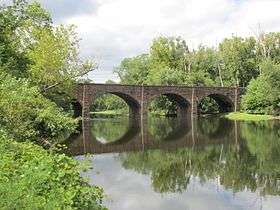 A stone arch bridge built in 1867 which still spans the Farmington River in Windsor, Connecticut.
 The Saville Dam impounds the East Branch Farmington River to form Barkhamsted Reservoir.
 Town Bridge, built in 1895 over the Farmington River in Canton, Connecticut.
See also
References
- 1 2 Farmington River Watershed: Water Quality Assessment Report (PDF). Massachusetts: Commonwealth of Massachusetts. 2001. p. 9.
- ↑ Farmington River Watershed Summary (PDF). Connecticut: Connecticut Department of Energy and Environmental Protection. 2012. p. 1. Retrieved 15 February 2016.
- 1 2 U.S. Geological Survey. National Hydrography Dataset high-resolution flowline data. The National Map, accessed April 1, 2011
- ↑ "Farmington River Watershed Association". Farmington River Watershed Association. Retrieved 23 September 2010.
- ↑ "Wild & Scenic". Farmington River Watershed Association. Farmington River Watershed Association. Retrieved 15 February 2016.
- ↑ "Tariffville (Route 189) to Highway 187 (Tariffville Gorge) (Tville)". American Whitewater. Retrieved 23 September 2010.
- ↑ "Farmington, W. Branch, Massachusetts, US". American Whitewater. Retrieved 23 September 2010.
- ↑ "USGS Real-Time Water Data for Connecticut". USGS. Retrieved 23 September 2010.
- ↑ "H.R 316 - 113th Congress". United States Congress. Retrieved 12 April 2013.
- ↑ "New York Indian Tribes". Access Genealogy.com. Retrieved September 29, 2010.
- ↑ "Spoonville Dam is gone!". Farmington River Watershed Association. Farmington River Watershed Association. Retrieved 15 February 2016.
- ↑ Federal Writers' Project. Connecticut: A Guide to Its Roads, Lore and People. US History Publishers. p. 500. ISBN 978-1-60354-007-0. Retrieved 23 September 2010.
- ↑ Susan Babbitt (February 15, 1972). "National Register of Historic Places Inventory/Nomination: Farmington River Railroad Bridge" (pdf). National Park Service.
- ↑ Clouette, Matthew (February 20, 1984). "National Register of Historic Places Inventory-Nomination: Drake Hill Road Bridge" (PDF). National Park Service. and Accompanying photos, exterior and interior, from 1983
- ↑ Bruce Clouette & Hoang Tinh (April 30, 1998). "National Register of Historic Places Inventory/Nomination: Town Bridge" (pdf). National Park Service.
- ↑ "Richards Corner Bridge". Bridgehunter.com: Historic and Notable Bridges of the U.S. Retrieved 22 March 2016.
- ↑ "Pleasant Valley Bridge". Bridgehunter.com: Historic and Notable Bridges of the U.S. Retrieved 15 February 2016.
- ↑ "Unionville Bridge". Bridgehunter.com: Historic and Notable Bridges of the U.S. Retrieved 22 March 2016.
- 1 2 "Nedeau, E.J. 2008. Freshwater Mussels and the Connecticut River Watershed. Connecticut River Watershed Council, Greenfield, MA." (PDF). Retrieved 2012-02-06.
External links
- Farmington River Watershed Association
- USGS site
- Farmington River Paddling Maps
- Farmington River Anglers Association