Faltschonhorn
| Faltschonhorn | |
|---|---|
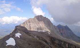 View of Piz Aul from the summit | |
| Highest point | |
| Elevation | 3,022 m (9,915 ft) |
| Prominence | 249 m (817 ft) [1] |
| Parent peak | Piz Aul |
| Coordinates | 46°36′45″N 9°6′53.5″E / 46.61250°N 9.114861°ECoordinates: 46°36′45″N 9°6′53.5″E / 46.61250°N 9.114861°E |
| Geography | |
 Faltschonhorn Location in Switzerland | |
| Location | Graubünden, Switzerland |
| Parent range | Lepontine Alps |
The Faltschonhorn is a mountain of the Swiss Lepontine Alps, located west of Vals in the canton of Graubünden. It lies on the range between the Val Lumnezia and the Valser Tal, south of Piz Aul.
References
External links
This article is issued from Wikipedia - version of the 9/26/2016. The text is available under the Creative Commons Attribution/Share Alike but additional terms may apply for the media files.