Ewing (unincorporated community), New Jersey
| Ewing, New Jersey | |
|---|---|
| Unincorporated community | |
|
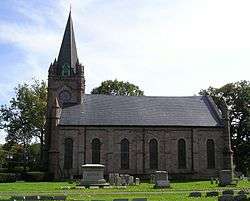
The Ewing Presbyterian Church in Ewing. | |
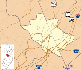 Ewing, New Jersey  Ewing, New Jersey  Ewing, New Jersey Location of Ewing in Mercer County Inset: Location of county within the state of New Jersey | |
| Coordinates: 40°16′11″N 74°48′00″W / 40.26972°N 74.80000°WCoordinates: 40°16′11″N 74°48′00″W / 40.26972°N 74.80000°W | |
| Country |
|
| State |
|
| County | Mercer |
| Township | Ewing |
| Elevation[1] | 157 ft (48 m) |
| GNIS feature ID | 876247[1] |
Ewing is a section of Ewing Township in Mercer County, New Jersey, United States.[2] Located at the intersection of Upper Ferry Road and Scotch Road, it is one of the oldest settlements in Ewing Township and dates back to the 18th century. The community was known as Carleton before adopting its current name.[3]
References
- 1 2 "Ewing". Geographic Names Information System. United States Geological Survey.
- ↑ Locality Search, State of New Jersey. Accessed January 25, 2015.
- ↑ Jo Ann Tesauro (2002). Images of America: Ewing Township. Arcadia Publishing. p. 8. ISBN 0-7385-1040-8.
The Carleton/Ewing/Ewing Presbyterian Church area was a small village at the intersection of today's Upper Ferry and Scotch Roads and the lands to the north, where the railroad crosses Scotch Road. It contained nine homesteads, a blacksmith, a wheelwright shop, a church and a flour mill.

This article is issued from Wikipedia - version of the 6/8/2016. The text is available under the Creative Commons Attribution/Share Alike but additional terms may apply for the media files.