Çivril
| Çivril | |
|---|---|
 Çivril | |
| Coordinates: 38°18′5″N 29°44′19″E / 38.30139°N 29.73861°ECoordinates: 38°18′5″N 29°44′19″E / 38.30139°N 29.73861°E | |
| Country |
|
| Province | Denizli |
| Government | |
| • Mayor | İbrahim Hakkı Aslan (CHP) |
| • Kaymakam | Muzaffer Başıbüyük |
| Area[1] | |
| • District | 1,478.45 km2 (570.83 sq mi) |
| Elevation | 941 m (3,087 ft) |
| Population (2012)[2] | |
| • Urban | 18,134 |
| • District | 61,004 |
| • District density | 41/km2 (110/sq mi) |
| Website |
www |
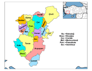
Çivril is a town and district of Denizli Province in the inner Aegean region of Turkey. Çivril district area neighbors those of two districts of Uşak Province to its north, namely Sivaslı and Karahallı, and four districts of Afyonkarahisar Province from the north-east to the south which are, clockwise, Sandıklı, Dinar, Dazkırı and Dazkırı, and to its south-west, three districts of the same province as itself depending Denizli. These last three are Bekilli, Çal and Baklan.
It is the most populated district of the province after Denizli center and is situated on a plain to the northeast of the city of Denizli, being actually closer to the neighboring provincial seat of Uşak.
The population of the district center is 17,989 and the whole district (including the rural area) is 61,815.
General features
The weather is dry and hot in summer, cold in winter. The villagers of Çivril are mostly occupied with growing the district's well-known tasty apples. Many more migrated to work in Germany and other European countries in the 1960s. Thus Çivril has a number of wealthy citizens living abroad or in Istanbul and in summer is populated with returning families for holiday. But in general this is a typical quiet rural Anatolian district.
History
Beycehöyük
During an excavation carried out by the British achaeologists Prof. Seton Lloyd and Prof. James Mellaart between 1953 and 1959 at Beycehöyük, 6 km (4 mi) south of the town of Çivril, several artefacts dating back to the Copper Age (circa 3000 BC) were found. It is assumed that Beycehöyük was the centre of the Arzawa kingdom, contemporaries of the Hittite Empire. Later on Phrygians, Carians, Lydians, Persians and Macedonians passed through the region during recorded history but left very few traces.
It is assumed that the relics of raiders and chariots in mounds and on rocks found at Yavuzca farm, 20 km (12 mi) from Çivril, date back to the Phrygians in whose time the most notable settlement here was called Eumeneia. A tomb located on Beycehöyük dates from Seljuk era.
Turkish era
A village depending Sandıklı until the 1880s, Çivril gained importance once it became the terminus of a branch of the İzmir-Dinar railway which reached here in 1889. The railway was later extended from Dinar further east to Eğirdir in 1912. Çivril continued to grow by becoming a township with its own municipality in 1892 and a district center in 1910, attached at first to Afyonkarahisar and to Denizli after 1925. The railway line was closed in 1988 and the transportation relies today on intercity buses.
Lake Işıklı
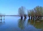
Çivril district area is notable by the large size within its boundaries of Lake Işıklı, a freshwater lake which is an important fishing reserve and recreational are for its region, aside from being one of the sources of Büyük Menderes River. The lake lies at an altitude of 821 m and its area is 73 square kilometres. Its waters are also used for irrigation for the surrounding agricultural lands. It is an important site for breeding waterbirds and large numbers of wintering wildfowl. It has been proposed as an Important Bird Area
The lake is at about 20 km (12 mi) south of Çivril and extends in Çivril Plain. ıt is fed by streams from further east. Another stream, Işıklı Stream, in its turn, departs from the lake to join later Büyük Menderes River.
Other places of interest
- The ancient and as yet superficially explored city of Eumeneia is located on the shore of Lake Işıklı near Çivril and the locality is arranged into a recreational area.
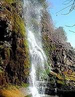
- There are a number of waterfalls on Işıklı Stream between Lake Işıklı and Büyük Menderes River, among which the falls called Gümüşsu is famous for the natural beauty of the surroundings which are arranged into a recreational area.
- To the north of the district center is the beautiful township of Gürpınar which was previously known as Bulkaz. Another waterfall is located practically within the township.
See also
References
- ↑ "Area of regions (including lakes), km²". Regional Statistics Database. Turkish Statistical Institute. 2002. Retrieved 2013-03-05.
- ↑ "Population of province/district centers and towns/villages by districts - 2012". Address Based Population Registration System (ABPRS) Database. Turkish Statistical Institute. Retrieved 2013-02-27.
- Falling Rain Genomics, Inc. "Geographical information on Çivril, Turkey". Retrieved 2008-10-23.
External links
| Wikimedia Commons has media related to Çivril. |
| ||