Erro (river)
| Erro | |
|---|---|
 | |
 | |
| Country | Italy |
| Basin | |
| Main source | Monte Ermetta |
| River mouth |
Bormida at Terzo (AL) 222 m (728 ft) |
| Basin size | 246.9 km2 (95.3 sq mi)[1] |
| Physical characteristics | |
| Length | 46.5 km (28.9 mi)[2] |
| Discharge |
|
The Erro (in Piedmontese Er) is a 46-kilometre (29 mi) torrent of north-west Italy, a right tributary of the Bormida.
Geography
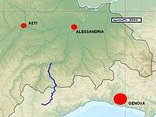
The river rises in the Ligurian Province of Savona at an elevation 1,267 metres (4,157 ft) on Monte Ermetta, to the west of Monte Beigua. Having passed through the territory of Sassello, the river enters the Piedmontese Province of Alessandria at Ponte Erro (Malvicino). Its course takes it past Cartosio, Rivere, Castelletto d'Erro, Arzello, and Melazzo before joining the Bormida at Terzo, a little upstream from Acqui Terme at an elevation of 222 metres (728 ft).
Sources
The initial version of this article was a translation from it:Erro (torrente), its counterpart in the Italian Wikipedia.
Coordinates: 44°39′52″N 8°25′47″E / 44.6645°N 8.4297°E
References
- 1 2 AA.VV. "Elaborato I.c/7". Piano di Tutela delle Acque - Revisione del 1º luglio 2004; Caratterizzazione bacini idrografici (PDF) (in Italian). Regione Piemonte. Retrieved 2016-07-25.
- ↑ AA.VV. "Elaborato I.c/5". Piano di Tutela delle Acque - Revisione del 1º luglio 2004; Caratterizzazione bacini idrografici (PDF) (in Italian). Regione Piemonte. Retrieved 2016-07-25.
![]() Media related to Erro (stream) at Wikimedia Commons
Media related to Erro (stream) at Wikimedia Commons