Eritrean Highlands

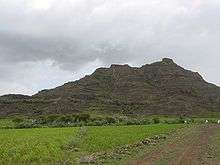
The Eritrean Highlands are a mountainous region in central Eritrea that are bordered to the south by the Mareb River. It is a continuation of the Ethiopian Highlands to the south. The region has seen tremendous deforestation since the colonial period, which began in the late 19th century. The Highlands are at particular risk of deforestation and associated soil erosion. Furthermore, the region, lying south of the Sahel are at particular risk of desertification and frequent drought. The Highlands experience, as most tropical regions, two seasons; the rainy season (kremti) is from June-September while the dry season is from September to June. The average temperature for Asmara, which is 2,340 m (7,677 ft) above sea level is approximately 16°C, but other places range from about 10°C to 25°C.[1]
Geography
The Eritrean Highlands are drained by four major rivers towards Sudan and by several smaller rivers into the Red Sea coast of Eritrea. Flowing towards Sudan and the Nile River are the Gash and Setit Rivers, while towards Sudan without reaching the Nile are the Barka and Anseba Rivers. The Eastern Escarpment of Eritrea is drained by numerous small streams.[2]
The highest point in Eritrea is located in the Eritrean Highlands at Emba Soira 116 m (381 ft) above sea level.[3]
Many believe that forest cover in the Eritrean Highlands was as high as 30% but has since declined to 1%,[4] however, others including Louise Latt have suggested that there has never been such a dramatic decline in forest cover.[5]
The eastern edge of the Highlands falls off dramatically towards the Red Sea which causes two climatic systems to overlap. This region is oft noted for its perennial forest cover. This is also the region that Eritrea's Merara coffee is grown.[6]
The soil conditions in the Eritrean Highlands is also quite complex. The predominant soils are chromic, eutric, and calsic cambisols of strong red colour. Other soils found in the highlands are lithosols, xerosols and fluvisols.[7]
See also
References
- ↑ Mussie Tesfagiorgis G. (2010). Eritrea. ABC-CLIO. pp. 10–11. ISBN 978-1-59884-232-6.
- ↑ Philip's (1994). Atlas of the World. Reed International. pp. 94–95. ISBN 0-540-05831-9.
- ↑ "Location & Geography of Eritrea". Eritrea.be. Retrieved 24 November 2016.
- ↑ Boerma, Pauline. "Assessing Forest Cover Change in Eritrea — A Historical Perspective" (PDF). Mountain Research and Development. Archived from the original (PDF) on September 30, 2007. Retrieved 2007-01-17.
- ↑ Louise Latt. "Eritrea Re-photographed: Landscape Changes in the Eritrean Highlands 1890-2004" (PDF). Retrieved 2006-09-26.
- ↑ Ethiopian Geographical Journal. Mapping and Geography Institute.
- ↑ "FOSA Country Report". Retrieved 2007-01-17.