Erisos
| Erisos Έρισος | |
|---|---|
 Erisos | |
|
Location within the regional unit 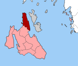 | |
| Coordinates: 38°24′N 20°35′E / 38.400°N 20.583°ECoordinates: 38°24′N 20°35′E / 38.400°N 20.583°E | |
| Country | Greece |
| Administrative region | Ionian Islands |
| Regional unit | Kefalonia |
| Municipality | Kefalonia |
| • Municipal unit | 78.1 km2 (30.2 sq mi) |
| Population (2011)[1] | |
| • Municipal unit | 1,472 |
| • Municipal unit density | 19/km2 (49/sq mi) |
| Time zone | EET (UTC+2) |
| • Summer (DST) | EEST (UTC+3) |
| Vehicle registration | ΚΕ |
Erisos (Greek: Έρισος) is a former municipality on the island of Kefalonia, Ionian Islands, Greece. Since the 2011 local government reform it is part of the municipality Kefalonia, of which it is a municipal unit.[2] It is located in the northernmost part of the island, and has a land area of 78.114 km².[3] It population was 1,472 at the 2011 census. The seat of the municipality was in Vasilikades but more known are the two small harbours Fiskardo and Asos. Other town are Antipáta, Mesovoúnia, and Komitáta.
External links
- Official website (English) (Greek)
References
- ↑ "Απογραφή Πληθυσμού - Κατοικιών 2011. ΜΟΝΙΜΟΣ Πληθυσμός" (in Greek). Hellenic Statistical Authority.
- ↑ Kallikratis law Greece Ministry of Interior (Greek)
- ↑ "Population & housing census 2001 (incl. area and average elevation)" (PDF) (in Greek). National Statistical Service of Greece.
This article is issued from Wikipedia - version of the 12/1/2016. The text is available under the Creative Commons Attribution/Share Alike but additional terms may apply for the media files.