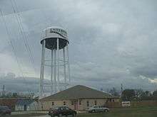
Enterprise, Alabama
| Enterprise, Alabama | |
|---|---|
| City | |
|
| |
| Motto: "City of Progress" | |
 Location in Coffee County and the state of Alabama | |
| Coordinates: 31°19′39″N 85°50′40″W / 31.32750°N 85.84444°WCoordinates: 31°19′39″N 85°50′40″W / 31.32750°N 85.84444°W | |
| Country | United States |
| State | Alabama |
| Counties | Coffee, Dale |
| Founded | 1896 |
| Government | |
| • Mayor | Kenneth Boswell |
| Area | |
| • Total | 31.3 sq mi (81.1 km2) |
| • Land | 31.2 sq mi (80.9 km2) |
| • Water | 0.08 sq mi (0.2 km2) |
| Elevation | 358 ft (109 m) |
| Population (2010)[1] | |
| • Total | 26,562 |
| • Estimate (2015)[2] | 27,978 |
| • Density | 850/sq mi (328.3/km2) |
| Time zone | CST (UTC-6) |
| • Summer (DST) | CDT (UTC-5) |
| ZIP code | 36330-36331 |
| Area code(s) | 334 |
| FIPS code | 01-24184 |
| GNIS feature ID | 0118005 |
| Website |
www |

Enterprise is a city in the southeastern part of Coffee County and the southwestern part of Dale County in the southeastern part of Alabama in the Southern United States. The population was 26,562 at the 2010 census.[1] Enterprise is the primary city of the Enterprise Micropolitan Statistical Area (with the portion of the city located in Dale County part of the Ozark Micropolitan Statistical Area), and is also part of the Dothan-Enterprise-Ozark Combined Statistical Area.
Enterprise is famous for the Boll Weevil Monument, a large monument of a woman holding a boll weevil, which is located in the middle of Main Street. The city erected the statue because the destruction of the cotton crop by the boll weevil had led to agricultural diversity, starting with peanuts and more prosperity than had ever come from cotton alone. It is said to be the only statue to an insect pest in the world. Enterprise is right outside of Fort Rucker, an Army base which is the home of Army Aviation.
Enterprise is home to Enterprise State Community College.
History
Founding of the Boll Weevil Monument

The founder of Enterprise, John Henry Carmichael, first settled there in 1881. Carmichael opened a store, which attracted more settlers to the area, and by the next year a post office was relocated from the settlement of Drake Eye to the north to Enterprise. In 1896, with 250 people having settled there, the city of Enterprise incorporated. Soon afterward, the Alabama Midland Railway came to Enterprise, bringing with it opportunities for commerce and growth. By 1906, ten years after the city incorporated, its population had grown to 3,750.[3]
The way of life in Enterprise came under threat in 1915. An infestation of boll weevils had found its way into the region's cotton crops, resulting in the destruction of most of the cotton in Coffee County. Facing economic ruin, the nearly bankrupt area farmers were forced to diversify, planting peanuts and other crops in an effort to lessen the damage and recoup some of the losses inflicted upon them by the invading insect.[3]
Two years later, Coffee County was the leading producer of peanuts in the United States. Enterprise was able not only to stave off disaster, but its economy was renewed by the thriving new crop base. In appreciation, the people of Enterprise erected a monument in the city center to what the monument describes as their "herald of prosperity"; the boll weevil.[4] The Boll Weevil Monument was dedicated on December 11, 1919, as a reminder of how the city adjusted in the face of adversity. It is the only monument to an agricultural pest in the world.[3]

March 2007 tornado
In the early afternoon of March 1, 2007, Enterprise was hit by a devastating tornado (rated EF4) during the February–March 2007 Tornado Outbreak.[5] The tornado caused nine deaths, injured over 121 others, and left severe damage in the city estimated at nearly $307,000,000, becoming the worst disaster in Enterprise history. The worst damage occurred at Enterprise High School, where eight students died after one hallway was almost completely destroyed. A quarter-mile (400 m) wide swath through the downtown area was devastated, with at least 370 houses damaged or destroyed. The National Guard was called into the city, and a dusk-to-dawn curfew was implemented immediately after the disaster. President Bush, who arrived the morning of March 3, declared the county a disaster area. An AmeriCorps team was sent to the city to help organize and participate in disaster relief.

As of June 2008 the Hillcrest Elementary School which was destroyed during the tornado was being rebuilt at the site of the former Enterprise High School. The high school was to be relocated to the west end of the Boll Weevil Circle. It was due to be rebuilt by the 2010–11 school year at a cost of over $80,000,000. Until then the students were required to go to school at the local community college where they built trailers to add classrooms. The high school was rebuilt and reopened on August 23, 2010.[6][7]
Demographics
| Historical population | |||
|---|---|---|---|
| Census | Pop. | %± | |
| 1900 | 610 | — | |
| 1910 | 2,322 | 280.7% | |
| 1920 | 3,013 | 29.8% | |
| 1930 | 3,702 | 22.9% | |
| 1940 | 4,353 | 17.6% | |
| 1950 | 7,288 | 67.4% | |
| 1960 | 11,410 | 56.6% | |
| 1970 | 15,591 | 36.6% | |
| 1980 | 18,033 | 15.7% | |
| 1990 | 20,123 | 11.6% | |
| 2000 | 21,178 | 5.2% | |
| 2010 | 26,562 | 25.4% | |
| Est. 2015 | 27,978 | [2] | 5.3% |
| U.S. Decennial Census[8] | |||
2010
As of the 2010 census, there were 26,562 people, 10,513 households, and 7,196 families residing in the city. The population density was 850 people per square mile (328.3/km2). There were 11,616 housing units at an average density of 371.1 per square mile (143.2/km2). The racial makeup of the city was 69.4% White, 20.7% Black or African American, 0.5% Native American, 2.0% Asian, 0.3% Pacific Islander, 4.1% from other races, and 2.9% from two or more races. Hispanic or Latino of any race were 8.8% of the population.
There were 10,513 households out of which 32.2% had children under the age of 18 living with them, 50.3% were married couples living together, 13.9% had a female householder with no husband present, and 31.6% were non-families. 25.6% of all households were made up of individuals and 8.5% had someone living alone who was 65 years of age or older. The average household size was 2.50 and the average family size was 3.00.
In the city the population was spread out with 25.4% under the age of 18, 9.3% from 18 to 24, 29.1% from 25 to 44, 23.3% from 45 to 64, and 12.9% who were 65 years of age or older. The median age was 34.4 years. For every 100 females there were 96.2 males. For every 100 females age 18 and over, there were 99.6 males.
The median income for a household in the city was $48,042, and the median income for a family was $63,036. Males had a median income of $45,556 versus $31,588 for females. The per capita income for the city was $25,185. About 13.9% of families and 15.6% of the population were below the poverty line, including 23.7% of those under age 18 and 12.9% of those age 65 or over.
2000
As of the 2000 census, there were 21,178 people, 8,533 households, and 5,973 families residing in the city. The population density was 684.2 people per square mile (264.2/km2). There were 9,641 housing units at an average density of 311.5 per square mile (120.3/km2). The racial makeup of the city was 71.62% White, 22.95% Black or African American, 0.48% Native American, 1.60% Asian, 0.16% Pacific Islander, 1.27% from other races, and 1.92% from two or more races. Hispanic or Latino of any race were 3.88% of the population.
There were 8,533 households out of which 33.1% had children under the age of 18 living with them, 53.6% were married couples living together, 13.3% had a female householder with no husband present, and 30.0% were non-families. 25.7% of all households were made up of individuals and 9.5% had someone living alone who was 65 years of age or older. The average household size was 2.45 and the average family size was 2.95.
In the city the population was spread out with 25.4% under the age of 18, 9.3% from 18 to 24, 27.5% from 25 to 44, 23.8% from 45 to 64, and 14.1% who were 65 years of age or older. The median age was 37 years. For every 100 females there were 91.3 males. For every 100 females age 18 and over, there were 86.8 males.
The median income for a household in the city was $37,661, and the median income for a family was $45,510. Males had a median income of $37,131 versus $20,560 for females. The per capita income for the city was $20,493. About 10.7% of families and 13.6% of the population were below the poverty line, including 21.0% of those under age 18 and 11.1% of those age 65 or over.
Education
Enterprise is served by Enterprise City Schools. Enterprise is also home to Enterprise State Community College,[9] (formerly known as Enterprise State Junior College).[10] A two-year college, the Enterprise campus is home to the Boll Weevils. Enterprise is also the home of Enterprise Preparatory Academy, a K2-12 private Christian school. Enterprise Preparatory Academy is a member of the Alabama Independent School Association.
Point of interest
Murals were produced from 1934 to 1943 in the United States through the Section of Painting and Sculpture, later called the Section of Fine Arts, of the Treasury Department. Paul Theodore Arlt was an artist with the United States Department of the Treasury's Section of Fine Arts and painted the post office mural, The Section, in the Enterprise post office in 1941. The post office was torn down in 1991, but Mr. Arlt's mural, "Saturday in Enterprise," was preserved and now hangs in the Enterprise Public Library.[11]
Media
A weekly newspaper, The Southeast Sun, has published since 1982.[12] The Enterprise Ledger is published Tuesday-Friday and Sunday, and has been in circulation since 1898.[13]
Music
"Force Majeure", a composition for symphonic band by Rob Grice (published in 2009 by Birch Island Music Press) is dedicated to Enterprise High School "03-01-2007 – We Shall Never Forget". The piece was featured by the North Star Wind Symphony in concert on March 11, 2010, at the Lone Star College-North Harris campus.
The song "Your Guardian Angel" by The Red Jumpsuit Apparatus is dedicated to the eight students who lost their lives on 03-01-2007 when a tornado half-a-mile wide hit the high school. The twister claimed 8 lives and destroyed Enterprise High School. The song "Held In His Love" by The Springs (band) was written by Stewart Halcomb, a student inside Enterprise High School (Alabama) on March 1, 2007 and dedicated to the 8 friends he lost that day.
BamaJam
Enterprise was home to the BamaJam Music Festival featuring multiple acts performing on different stages in three days. Attendance has reached as high as 100,000 each night. In 2008, headliners included Hank Williams, Jr., ZZ Top, Lynyrd Skynyrd, and Trace Adkins, and in 2009, headliners included Taylor Swift, Blake Shelton, Charlie Daniels, Alan Jackson, Brooks and Dunn, The Black Crowes, and Kid Rock.[14]
BamaJam 2011 was cancelled, but the show returned to BamaJam Farms in June 2012 with Eric Church, Tim McGraw, Ronnie Milsap, Alan Jackson, the Zac Brown Band, Sheryl Crow, and Kid Rock.
Notable people
- Kendrick Adams, NFL outside linebacker
- Curly Chalker, country and jazz pedal steel guitarist
- Clint Crisher, R&B singer
- Juli Crockett, retired professional boxer, playwright, and theater director
- Jimmy DuBose, former NFL player
- Terry Everett, former representative from Alabama's 2nd congressional district
- Mark Fuller, federal judge for the U. S. District Court, Middle District of Alabama
- Kenneth A. Gibson, former mayor of Newark, New Jersey
- Stewart Halcomb, vocalist of The Springs (band)
- David Howard, former NFL linebacker
- April Hunter, professional wrestler and model
- Jamey Johnson, country music artist born in Enterprise
- Jimmy McClain, NFL player
- Michael McDowell, screenwriter and author of several Southern Gothic novels
- Ben Paschal, reserve outfielder for the 1927 Yankees
- Thomas Virgil Pittman, former federal judge on the United States District Court for the Southern District of Alabama and the United States District Court for the Middle District of Alabama
- Cedric Smith, former NFL running back
- Aud Tuten, former NHL player with the Chicago Black Hawks (1941–43)
- Mark Wilkerson, lead singer of Course of Nature and husband of Melissa Joan Hart
Climate
The climate in this area is characterized by hot, humid summers and generally mild winters. According to the Köppen Climate Classification system, Enterprise has a humid subtropical climate, abbreviated "Cfa" on climate maps.[15] The temperatures are moderated by it's proximity to the Gulf Coast, and is part of the Wiregrass Region of Southern Alabama, Georgia, and Florida.
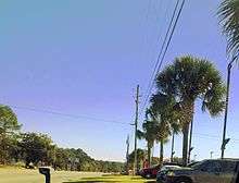
It is located in USDA Plant Hardiness Zone 8B with an average minimum temperature of 15 to 20 (F).[16] As a result of its mild to warm climate, palm trees such as Butia capitata, Sabal palmetto, Phoenix canariensis, Cycas revoluta, and Trachycarpus fortunei are widely grown throughout the city.
| Climate data for Enterprise, Alabama, 1981–2010 normals | |||||||||||||
|---|---|---|---|---|---|---|---|---|---|---|---|---|---|
| Month | Jan | Feb | Mar | Apr | May | Jun | Jul | Aug | Sep | Oct | Nov | Dec | Year |
| Record high °F (°C) | 81 (27) |
82 (28) |
88 (31) |
93 (34) |
99 (37) |
104 (40) |
104 (40) |
103 (39) |
100 (38) |
92 (33) |
87 (31) |
82 (28) |
104 (40) |
| Average high °F (°C) | 60 (16) |
64 (18) |
71 (22) |
78 (26) |
85 (29) |
90 (32) |
92 (33) |
91 (33) |
87 (31) |
80 (27) |
71 (22) |
62 (17) |
77.6 (25.3) |
| Average low °F (°C) | 38 (3) |
42 (6) |
47 (8) |
53 (12) |
62 (17) |
69 (21) |
71 (22) |
71 (22) |
66 (19) |
57 (14) |
48 (9) |
40 (4) |
55.3 (12.9) |
| Record low °F (°C) | −1 (−18) |
10 (−12) |
17 (−8) |
30 (−1) |
40 (4) |
49 (9) |
55 (13) |
59 (15) |
39 (4) |
32 (0) |
18 (−8) |
6 (−14) |
−1 (−18) |
| Average precipitation inches (mm) | 5.31 (134.9) |
4.61 (117.1) |
5.87 (149.1) |
3.98 (101.1) |
3.58 (90.9) |
5.00 (127) |
5.98 (151.9) |
4.53 (115.1) |
3.86 (98) |
3.03 (77) |
4.09 (103.9) |
4.49 (114) |
54.33 (1,380) |
| Source: US Climate Data,[17] Weather.com [18] | |||||||||||||
References
- 1 2 "Geographic Identifiers: 2010 Demographic Profile Data (G001): Enterprise city, Alabama". U.S. Census Bureau, American Factfinder. Retrieved June 6, 2014.
- 1 2 "Annual Estimates of the Resident Population for Incorporated Places: April 1, 2010 to July 1, 2015". Retrieved July 2, 2016.
- 1 2 3 "History of Enterprise". City of Enterprise. Retrieved February 6, 2010.
- ↑ Fleming, Jack; Fleming, Carolyn (2007). Thinking Places: Where Great Ideas Were Born. Trafford Publishing. pp. 275–276. ISBN 978-1-4251-2585-1.
- ↑ "Tornado Outbreak of March 1–2, 2007". National Weather Service. Retrieved December 7, 2010.
- ↑ http://www2.eprisenow.com/news/2010/aug/22/we-are-enterprise-ar-730114/
- ↑ http://www2.eprisenow.com/news/2010/aug/22/new-ehs-streets-named-ar-730111/
- ↑ United States Census Bureau. "Census of Population and Housing". Retrieved June 7, 2014.
- ↑ http://www.eocc.edu/
- ↑ Peterson's (2009). Two-Year Colleges – 2010 (Peterson's Two Year Colleges). 978-0768926880. p. 58.
- ↑ "Public Library Mural - Enterprise, Alabama". livingnewdeal.org. Living New Deal. Retrieved 10 October 2015.
- ↑ About Us. The Southeast Sun: Site.
- ↑ Contact us. The Enterprise Ledger
- ↑ "Official site of Bama Jam". Retrieved December 21, 2010.
- ↑ Climate Summary for Enterprise, Alabama
- ↑ "USDA Alabama Hardiness Zone Map". Plant Hardiness. USDA. Retrieved 23 November 2016.
- ↑ "Enterprise Alabama Climate". US Climate Data. Retrieved November 23, 2016.
- ↑ "Enterprise, Alabama". Weather.com. Retrieved November 23, 2016.
External links
| Wikimedia Commons has media related to Enterprise, Alabama. |
- City of Enterprise official website
- Enterprise Chamber of Commerce
- Enterprise Public Library
- The Enterprise Ledger
Municipalities and communities of Coffee County, Alabama, United States | ||
|---|---|---|
| Cities | 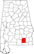 | |
| Towns | ||
| Unincorporated communities | ||
| Footnotes | ‡This populated place also has portions in an adjacent county or counties | |
Municipalities and communities of Dale County, Alabama, United States | ||
|---|---|---|
| Cities |  | |
| Towns | ||
| CDP | ||
| Unincorporated communities | ||
| Footnotes | ‡This populated place also has portions in an adjacent county or counties | |