Encinitas, California
| Encinitas, California | ||
|---|---|---|
| City | ||
| City of Encinitas | ||
|
Aerial view of part of old town Encinitas showing Moonlight Beach on the left. Parallel with the shore is Historic Coast Highway 101, also parallel and further inland is Interstate 5 in California | ||
| ||
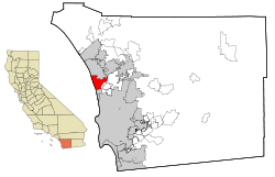 Location of Encinitas within San Diego County, California | ||
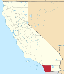
 Encinitas, California Location in the United States | ||
| Coordinates: 33°2′40″N 117°16′18″W / 33.04444°N 117.27167°WCoordinates: 33°2′40″N 117°16′18″W / 33.04444°N 117.27167°W | ||
| Country |
| |
| State |
| |
| County | San Diego | |
| Incorporated | October 1, 1986[1] | |
| Government | ||
| • Mayor | Kristin Gaspar[2] | |
| Area[3] | ||
| • Total | 19.990 sq mi (51.772 km2) | |
| • Land | 18.812 sq mi (48.722 km2) | |
| • Water | 1.178 sq mi (3.050 km2) 5.89% | |
| Elevation[4] | 82 ft (25 m) | |
| Population (April 1, 2010)[5] | ||
| • Total | 59,518 | |
| • Estimate (2013)[5] | 61,588 | |
| • Density | 3,000/sq mi (1,100/km2) | |
| Demonym(s) | Encinitan | |
| Time zone | Pacific (UTC-8) | |
| • Summer (DST) | PDT (UTC-7) | |
| ZIP codes | 92007, 92023, 92024 | |
| Area codes | 442/760 | |
| FIPS code | 06-22678 | |
| GNIS feature IDs | 1652705, 2410440 | |
| Website |
www | |


Encinitas is a beach city in the North County area of San Diego County, California. Located within Southern California, it is approximately 25 miles (40 km) north of San Diego and about 95 miles (153 km) south of Los Angeles. As of the 2010 census, the city had a population of 59,518, up from 58,014 at the 2000 census.
History
Encinitas is a Spanish name meaning "little oaks".[6]
The city was incorporated by 69.3% of the voters in 1986[7] from the communities of historic Encinitas, new Encinitas (Village Park, etc.), Leucadia, Cardiff-by-the-Sea and Olivenhain. The communities retain their identities and distinctive flavors.
Communities
Encinitas can be divided into five areas:
- Old Encinitas: a small beachside area featuring a mix of businesses and housing styles. Sitting along the coastal 101 highway, the Encinitas welcome arch, the famous surf break Swamis, Cardiff Kook statue, and the early 20th century La Paloma Theater are located here. Old Encinitas is divided from New Encinitas by a low coastal ridge.
- New Encinitas: a newer region which features a golf course, many shopping centers, and is composed of larger tract homes.
- Olivenhain: a semi-rural region in eastern Encinitas, composed of mostly single family homes, an active 4-H Club, and several private equestrian facilities. Olivenhain connects to Rancho Santa Fe via Encinitas Blvd.
- Leucadia: a coastal community of the city. Leucadia features tree-lined streets and boulevards. The community features art galleries, unusual stores, and restaurants, along with single family homes. This also contains beaches such as Beacons and Grandview.
- Cardiff-by-the-Sea: Encinitas' southernmost oceanfront community, which features streets named after British cities and classical composers, the Lux Art Institute, and the San Elijo Campus of Mira Costa College.
Geography

Encinitas is located at 33°2′40″N 117°16′18″W / 33.04444°N 117.27167°W.[8] According to the United States Census Bureau, the city has a total area of 20.0 square miles (52 km2). 18.8 square miles (49 km2) of it is land and 1.2 square miles (3.1 km2) of it (5.89%) is water. The city's elevation ranges between sea level and 180 feet (55 m) above sea level.
Encinitas lies on rugged coastal terrain. The city is bisected by a low-lying coastal ridge that separates New and Old Encinitas. In the north of the city, the coast rises in elevation and the land is raised up in the form of many coastal bluffs. The city is surrounded by Batiquitos Lagoon and San Elijo Lagoon to the north and south, respectively.
Climate
Encinitas has a very mild, Mediterranean climate. Average daily high temperature is 72 °F (22 °C). Temperatures below 40 °F (4 °C) and above 85 °F (29 °C) are rare. Average rainfall is about 10 inches (250 mm) per year. The wet season lasts during the winter and spring, when temperatures are usually cool. Average daytime temperatures hit 65F in winter and spring, when rain and marine layer (fog) are common (May Gray/June Gloom). Nighttime lows range from 45-55F. The dry season lasts from summer through fall, with average daytime temperatures ranging from 75-85F, and nighttime lows being from the upper 50s–60sF. Ocean water temperatures average 60F in winter, 64F in spring, 70F in summer, and 66F in fall. In winter, strong pacific storms can bring heavy rain. During the winter of 2015-2016, the area saw rounds of severe thunderstorms. Tornados touched down nearby.
Demographics
| Historical population | |||
|---|---|---|---|
| Census | Pop. | %± | |
| 1960 | 2,786 | — | |
| 1970 | 5,375 | 92.9% | |
| 1980 | 10,796 | 100.9% | |
| 1990 | 55,386 | 413.0% | |
| 2000 | 58,014 | 4.7% | |
| 2010 | 59,518 | 2.6% | |
| Est. 2015 | 62,930 | [9] | 5.7% |
2010
The 2010 United States Census[11] reported that Encinitas had a population of 59,518. The population density was 2,977.5 people per square mile (1,149.6/km²). The racial makeup of Encinitas was 51,067 (85.8%) White, 361 (0.6%) African American, 301 (0.5%) Native American, 2,323 (3.9%) Asian, 91 (0.2%) Pacific Islander, 3,339 (5.6%) from other races, and 2,036 (3.4%) from two or more races. Hispanic or Latino of any race were 8,138 persons (13.7%).
The Census reported that 58,990 people (99.1% of the population) lived in households, 123 (0.2%) lived in non-institutionalized group quarters, and 405 (0.7%) were institutionalized.
There were 24,082 households, out of which 6,997 (29.1%) had children under the age of 18 living in them, 12,113 (50.3%) were opposite-sex married couples living together, 1,950 (8.1%) had a female householder with no husband present, 981 (4.1%) had a male householder with no wife present. There were 1,359 (5.6%) unmarried opposite-sex partnerships, and 169 (0.7%) same-sex married couples or partnerships. 6,303 households (26.2%) were made up of individuals and 2,118 (8.8%) had someone living alone who was 65 years of age or older. The average household size was 2.45. There were 15,044 families (62.5% of all households); the average family size was 2.98.
The population was spread out with 12,285 people (20.6%) under the age of 18, 3,767 people (6.3%) aged 18 to 24, 16,584 people (27.9%) aged 25 to 44, 19,239 people (32.3%) aged 45 to 64, and 7,643 people (12.8%) who were 65 years of age or older. The median age was 41.5 years. For every 100 females there were 97.9 males. For every 100 females age 18 and over, there were 95.3 males.
There were 25,740 housing units at an average density of 1,287.7 per square mile (497.2/km²), of which 15,187 (63.1%) were owner-occupied, and 8,895 (36.9%) were occupied by renters. The homeowner vacancy rate was 1.0%; the rental vacancy rate was 5.3%. 39,101 people (65.7% of the population) lived in owner-occupied housing units and 19,889 people (33.4%) lived in rental housing units.
2000
As of the census[12] of 2000, there were 58,014 people, 22,830 households, and 14,291 families residing in the city. The population density was 3,035.6 inhabitants per square mile (1,172.1/km²). There were 23,843 housing units at an average density of 1,247.6 per square mile (481.7/km²). The racial makeup of the city was 86.60% White, 0.59% Black or African American, 0.46% Native American, 3.10% Asian, 0.12% Pacific Islander, 6.28% from other races, and 2.85% from two or more races. 14.80% of the population were Hispanic or Latino of any race.
There were 22,830 households out of which 31.0% had children under the age of 18 living with them, 50.1% were married couples living together, 8.8% had a female householder with no husband present, and 37.4% were non-families. 25.7% of all households were made up of individuals and 6.9% had someone living alone who was 65 years of age or older. The average household size was 2.52 and the average family size was 3.06.
In the city the population was spread out with 23.1% under the age of 18, 7.2% from 18 to 24, 33.4% from 25 to 44, 25.9% from 45 to 64, and 10.4% who were 65 years of age or older. The median age was 38 years. For every 100 females there were 99.2 males. For every 100 females age 18 and over, there were 96.3 males.
The median income for a household in the city was $63,954, and the median income for a family was $78,104. Males had a median income of $51,132 versus $38,606 for females. The per capita income for the city was $34,336. About 3.8% of families and 7.3% of the population were below the poverty line, including 6.9% of those under age 18 and 5.7% of those age 65 or over.
Arts and culture

Encinitas Ballet. Encinitas Ballet is an exceptional classical ballet studio in Encinitas. Established in 2008 by Sayat Asatryan former principal dancer of the Kremlin Ballet Theatre and Olga Tchekachova, former soloist of the Mariinsky Ballet II
Regular events
- April Street Fair: annual two-day street fair, held every April in downtown Encinitas[13]
- Deep Pit BBQ, held the end of May at the San Dieguito Heritage Museum, 450 Quail Gardens Dr.[14]*`
- Encinitas Environment Day: held on the 2nd Sunday of June- environmentally-themed games and entertainment for families.[15]
- Lima Bean Faire and Battle of the Beans Cook-off, held each September at the San Dieguito Heritage Museum, 450 Quail Gardens Dr.[16]
- Fall Festival: annual one-day street fair, held each November in downtown Encinitas.[17]
- OktoberFest: held the third Sunday in September to coincide with the start of the Oktoberfest celebrations in Germany.
- Classic Car Cruise Nights: classic cars line Coast Highway 101 in downtown Encinitas on the 3rd Thursday of each month, May–September.[18]
- The Wavecrest Woodie Meet: takes place once a year on the third Saturday of September at Moonlight State Beach. It is the largest rally of wooden bodied vehicles in the world and it is free to the public and to participants.
- Wellness Week: annual week-long program of events and special offers designed to help people learn about and experience ways to improve their well-being.[19]
- Salute to Education: Encinitas Chamber of Commerce Salute to Education event that is held each year in June honoring local teachers and students for their outstanding efforts during the current school year. This event is hosted each year by Rancho Santa Fe Security Systems.
- Switchfoot Bro-Am: annual free surf competition and outdoor music festival usually held in early July at Moonlight State Beach, home of the world's only Surf Jousting competition, along with several other competitive surfing events. All proceeds from the event go to local charities.[20]
Surfing Madonna
In 2011 Mark Patterson and Robert Nichols illegally installed a 10 by 10 feet (3 m × 3 m) mosaic of a surfing Virgin de Guadalupe on the north concrete support wall of the train bridge on Encinitas Boulevard, leading to a battle over whether it should be removed or preserved. It was named "the Surfing Madonna" by the media and public.[21][22]
Museums and other points of interest

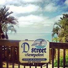
The Lux Art Institute and San Dieguito Heritage Museum are located in Encinitas. Other points of interest include the San Diego Botanic Garden, Self-Realization Fellowship temple and Hermitage, as well as the gardens which are routinely open to the public, the historic La Paloma Theater, Moonlight Beach, and one of California's classic downtown areas along historic Coast Highway 101. Surfing is a popular activity in Encinitas, particularly at Swami's, which is rated in the top 5 surf locations in the world, and is mentioned in a verse of The Beach Boys' song "Surfin' U.S.A."
Economy
Since 1982, the Encinitas 101 Main Street Association has helped keep downtown Encinitas economically viable yet historic & beachy. Downtown Encinitas is vibrant and full of thriving local salons, restaurants, shops, bars, and art galleries.[23] Downtown Encinitas is home to Hansens Surf Shop - San Diego's oldest and largest shop. It opened in 1961 and occupies over 20,00 square feet of retail space. [24]
Amtrak has a station in Downtown Encinitas [25] which is also home to the Farmer's Market. Coaster trains stop here multiple times a day, 7 days a week with service from Oceanside to San Diego. Amtrak trains stop here 3 times a day in each direction, everyday, with service from San Diego to Los Angeles. The Farmer's Market is here each Wednesday from 5pm to 8pm, the parking lot is host to over 40 vendors selling fresh produce, cheeses, specialty meats, breads, spices, etc. [26]
Government
The city is currently governed by a five-member city council, elected at-large to staggered four-year terms at two-year intervals, with a mayor chosen by, and from, the city council members.
In elections held in November 2012, Encinitas voted yes on ballot measures to allow them to directly elect its mayor, with term lengths of two years, rather than the mayor being chosen by members of the city council, for one year terms. The first such direct election for mayor took place in 2014.
The city has been repeatedly sued over policies which are aimed at undermining state affordable housing laws.[27]
State and federal representation
In the California State Legislature, Encinitas is in the 36th Senate District, represented by Republican Patricia Bates, and in the 76th Assembly District, represented by Republican Rocky Chávez.[28]
In the United States House of Representatives, Encinitas is in California's 49th congressional district, which has a Cook PVI of R +4[29] and is represented by Republican Darrell Issa.[30]
Education
School districts
Visual Art schools
Colleges
- California Institute for Human Science
- Mira Costa College District
- Mira Costa College, San Elijo Campus
- St. Katherine College
High schools
- Grauer School (Private, college preparatory)
- San Dieguito Academy
- Pacific Academy
- Sunset Continuation High School
Middle schools
- Diegueño Middle School
- Encinitas Country Day School (private Middle School)
- Grauer School (private)
- Oak Crest Middle School
- The Rhoades School (private)
Elementary schools
- Ada Harris Elementary School
- Cardiff Elementary School
- Capri Elementary School
- Encinitas Country Day School (private)
- Flora Vista Elementary School
- Ocean Knoll Elementary School
- Olivenhain Pioneer Elementary School
- Park Dale Lane Elementary School
- Paul Ecke Central Elementary School
- Rancho Encinitas Academy (private)
- The Rhoades School (private)
- Saint John The Evangelist School (private)
- Sanderling Waldorf School (private)
Notable people
Current residents
- Cindy Lee Berryhill, singer/songwriter
- Rob Crow, musician, member of Pinback and Thingy and the former math rock/indie rock pioneers Heavy Vegetable
- Tom DeLonge, guitarist-singer with Blink-182, and Angels & Airwaves
- Members of the band Destroy the Runner
- Richard Dreyfuss, American actor
- Mary Fleener, underground comics artist
- Jon Foreman, singer/guitarist of Switchfoot
- Tim Foreman, bassist for Switchfoot
- Robert Foxworth, actor
- Rune Glifberg, Danish professional skateboarder
- Lyn-Z Adams Hawkins, professional skateboarder
- Bucky Lasek, professional skateboarder
- Rob Machado, professional surfer
- Hugh Martin, Broadway and film composer, Meet Me in St. Louis
- Jack McDowell, baseball player and musician
- Mike McGill, professional skateboarder. inventor of the McTwist
- Jeremy McGrath, Supercross racer
- Paula Newby-Fraser, The Queen of Kona, eight-time Ironman Triathlon World Champion
- Marion Ross, actress, TV's Happy Days
- Candice Sanders, Miss California USA 2003
- Anoushka Shankar, sitar player and composer
- Peter Sprague, jazz guitarist, composer, arranger, audio engineer, record producer, and surfer
- Kenny Stills, American football wide receiver (NFL)
- Jack Tempchin, musician and songwriter of several Eagles hits
- Jamie Thomas, professional skateboarder
- Joe Walsh, guitarist, singer, and songwriter for The James Gang and the Eagles
- Danny Way, professional skateboarder
- Shaun White, Professional Snowboarder (2 time Olympic Gold Medalist) and Skateboarder
- Joji Yuasa, composer (b. 1929)
- John Wesley Professional Stuntman, former USA Bobsled Driver
Former residents
- Jerry Buss, owner of the Los Angeles Lakers
- Michael Chang, professional tennis player
- Charlie Chaplin, actor, founding member, United Artists
- Susann Cokal, author
- Chaya Czernowin, composer
- Tom Dempsey, professional football player
- Walter Evans-Wentz, anthropologist and writer
- Manny Farber, film critic
- Rick Froberg, artist, lead singer/guitarist of Pitchfork, Drive Like Jehu, Hot Snakes
- Tony Hawk, professional skateboarder
- Frankie Hejduk, soccer player
- Bobbi Jordan, actress[31]
- Bessie Love, actress
- Taryn Manning, American actress
- Jerry Mathers, Actor The Beaver, Leave It to Beaver
- Jessica Numsuwankijkul, lead singer and guitar player of Heliotropes
- Pauline Oliveros, American composer and accordion
- Harry Partch, composer and inventor
- Mary Pickford, actress, founding member, United Artists; Mary Pickford Institute
- Bobby Riggs, professional tennis player
- Ravi Shankar, acclaimed sitarist[32]
- Staciana Stitts,[33] 2000 Olympic gold medalist
- Eddie Vedder, lead singer of Pearl Jam
- Paramahansa Yogananda, Guru, Self-Realization Fellowship
- Emily Ratajkowski, model and actress
Sister cities
References
- ↑ "California Cities by Incorporation Date" (Word). California Association of Local Agency Formation Commissions. Retrieved August 25, 2014.
- ↑ "City Council". City of Encinitas. Retrieved December 3, 2014.
- ↑ "2010 Census U.S. Gazetteer Files – Places – California". United States Census Bureau.
- ↑ "Encinitas". Geographic Names Information System. United States Geological Survey. Retrieved November 2, 2014.
- 1 2 "Encinitas (city) QuickFacts". United States Census Bureau. Retrieved April 18, 2015.
- ↑ Gannett, Henry (1905). The Origin of Certain Place Names in the United States. Govt. Print. Off. p. 119.
- ↑ Legendary Locals of Encinitas. Arcadia Publishing. 2012. p. 35. ISBN 9781467100090.
- ↑ "US Gazetteer files: 2010, 2000, and 1990". United States Census Bureau. February 12, 2011. Retrieved 2011-04-23.
- ↑ "Annual Estimates of the Resident Population for Incorporated Places: April 1, 2010 to July 1, 2015". Retrieved July 2, 2016.
- ↑ "Census of Population and Housing". Census.gov. Retrieved June 4, 2015.
- ↑ "2010 Census Interactive Population Search: CA – Encinitas city". U.S. Census Bureau. Retrieved July 12, 2014.
- ↑ "American FactFinder". United States Census Bureau. Retrieved 2008-01-31.
- ↑ http://www.encinitas101.com/events/annual-aprilstreetfair/
- ↑ sdheritage.org
- ↑ "Encinitas Environmental Day". Retrieved December 21, 2012.
- ↑ sdheritage.org
- ↑ http://www.encinitas101.com/events/fall-festival/
- ↑ http://www.encinitas101.com/events/rods-woodies-classic-car-show/
- ↑ http://www.encinitas101.com/events/wellness-week/
- ↑ "Switchfoot Bro-Am".
- ↑ Surfing Madonna mosaic draws mass following. Associated Press. BakersfieldNow.com. June 7, 2011.
- ↑ Surfing Madonna mosaic in Southern California draws mass following. Julie Watson. Associated Press. Oakland Tribune. June 7, 2011. The Surfing Madonna – more correctly known as the "Save the Ocean Mosaic" is now re-installed on the wall of Cafe Ipe at the corner of Jasper Street and Pacific Coast Highway in Leucadia, CA 92024
- ↑ "Main Street Association". Encinitas101.
- ↑ "History of Hansens". Hansen Surf.
- ↑ "Amtrak". Amtrak California.
- ↑ "Encinitas Station Farmers Market". Encinitas 101.
- ↑ http://www.voiceofsandiego.org/topics/government/years-of-defying-state-affordable-housing-law-gets-encinitas-sued-again
- ↑ "Statewide Database". UC Regents. Retrieved November 20, 2014.
- ↑ "Partisan Voting Index Districts of the 113th Congress: 2004 & 2008" (PDF). The Cook Political Report. Retrieved January 5, 2012.
- ↑ "California's 49th Congressional District - Representatives & District Map". Civic Impulse, LLC.
- ↑ Barnes, Mike (November 26, 2012). "Actress Bobbi Jordan Dies at 75, She had a stint on "General Hospital" in the 1970s and appeared in the Lucille Ball musical "Mame."". The Hollywood Reporter. Retrieved December 8, 2012.
- ↑ "Indian sitar maestro Ravi Shankar dies". BBC News.
- ↑
External links
| Wikivoyage has a travel guide for Encinitas. |
- Official website
- Downtown Encinitas MainStreet Association
- Chamber of Commerce
- Encinitas Union School District
- Encinitas Parks Guide Google Maps
| Counties | ||
|---|---|---|
| Major city | ||
| Cities 100k - 250k | ||
| Cities and towns 20k - 99k | ||
| CDPs 20k+ | ||
| Bodies of water | ||
| Regions | ||
| Parks and Monuments | ||