Ellicott City, Maryland
| Ellicott City, Maryland | |
|---|---|
| Census-designated place | |
|
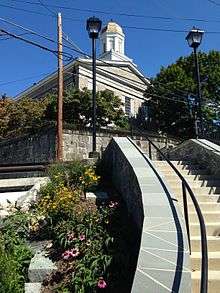
Main Street in Historic Ellicott City | |
| Nickname(s): "E.C.", "Old Ellicott City", "Historic Ellicott City" | |
 Location of Ellicott City, Maryland | |
| Coordinates: 39°16′5″N 76°47′56″W / 39.26806°N 76.79889°WCoordinates: 39°16′5″N 76°47′56″W / 39.26806°N 76.79889°W | |
| Country |
|
| State |
|
| County |
|
| Founded | 1772 |
| Incorporated | 1867–1935 |
| Historic District | 1973–present |
| Founded by | John, Andrew, and Joseph Ellicott |
| Government | |
| • Type | County council |
| • Councilman |
Jon Weinstein District 1 |
| Area | |
| • Total | 30.1 sq mi (77.9 km2) |
| • Land | 30.0 sq mi (77.6 km2) |
| • Water | 0.1 sq mi (0.3 km2) |
| Elevation | 180 ft (55 m) |
| Population (2010) | |
| • Total | 65,834 |
| • Estimate (2013)[1] | 66,476 |
| • Density | 2,200/sq mi (850/km2) |
| Time zone | Eastern (EST) (UTC-5) |
| • Summer (DST) | EDT (UTC-4) |
| ZIP codes | 21041–21043 |
| Area code(s) | 410, 443 |
| FIPS code | 24-26000 |
| GNIS feature ID | 0584282 |

Ellicott City is an unincorporated community and census-designated place, along with being the county seat of local government in Howard County, Maryland, United States. It is part of the Baltimore–Washington Metropolitan Area. The population was 65,834 at the U.S. Decennial Census of 2010.[2] It is the county seat of Howard County.[3] Founded in 1772, the town contains the B. & O. Railroad Museum's branch at the Ellicott City Station, built in 1830, and the first terminus of the initial line. The downtown historic district is located in the valley of the Tiber River, with its east end abutting the upper Western Branch of the Patapsco River. As of the 2000 U.S. Census, Ellicott City surpassed Towson, Maryland (county seat of neighboring Baltimore County) for the first time, as the largest unincorporated county seat in the country.
The downtown area in the Patapsco Valley is often called "Historic Ellicott City" or "Old Ellicott City", to distinguish it from the surrounding suburban unincorporated area that extends north to the Baltimore County line, south to the other large unincorporated town in Howard County, Columbia, and west to West Friendship.
History
Floods
The town is prone to flooding from the Patapsco River and Tiber Creek. These floods have had a major impact on the history of the town, often destroying important businesses and killing many. Ellicott City has had major devastating floods in 1817, 1837, 1868,[4] 1901, 1917, 1923, 1938, 1942, 1952, 1956, 1972 (Hurricane Agnes), 1975 (Hurricane Eloise), 1989, 2011 and 2016. The 1868 flood washed away 14 houses, killing 39 to 43 (accounts vary) in and around Ellicott City. It wiped out the Granite Manufacturing Cotton Mill, Charles A. Gambrill's Patapsco Mill, John Lee Carroll's mill buildings, and dozens of homes.[4] One mill was rebuilt by Charles Gambill, which remained in operation until a fire in 1916.[5]

A 1923 flood topped bridges, in 1952 an eight-foot wall of water swept the shops of Ellicott City, and a 1956 flood inflicted heavy damage at the Bartigis Brothers plant. A severe flood occurred in 1972 as a result of rainfall from the remnants of Hurricane Agnes, in which Ellicott City and the Old Main Line sustained serious damage.
On 21 June 1972, the Patapsco River valley flooded 14.5 feet (4.4 m) during Hurricane Agnes, taking out a concrete bridge, destroying the Jonathan Ellicott home, and the 1910 Victor Blode water filtration plant, and flooding Main Street to the Odd Fellows hall.[6]
On 27 Sept 1975, flooded 9.0 feet (2.7 m) from Hurricane Eloise. And floods occurred Sept 22, 1989 from Hurricane Hugo, and also on Sept 7, 2011, flooding 11.0 feet (3.4 m) from Tropical Storm Lee.
2016 flood
On July 30, 2016, a storm dropped six inches of rain in two hours on the city. The resulting flash flood caused severe damage in historic Ellicott City, especially along Main Street.[7] Many homes, roads, businesses, sidewalks, and more were destroyed by the flooding, including the city's landmark clock.[8] A state of emergency was declared, and two people died as a result of the flooding.[9][10]
Milling
In 1766 James Hood used the "Maryland Mill Act of 1669" to condemn 20 acres (8.1 ha) for a mill site adjacent to his river-side 157 acres (64 ha) property. His grist mill was built on the banks of the Patapsco River where the Frederick road (later known as the old National Road, then United States Route 40/Maryland Route 144) crossed (later known as Ellicott's Upper Mills).[11] His son Benjamin rebuilt the corn grinding mill after one of the frequent Patapsco floods in 1768. Benjamin Hood then sold the mill to Joseph Ellicott in 1774 for 1,700 pounds. In later years the B&O railroad ran through the property, with track laid over the graves of the Hood family.[12]
On 24 April 1771, three Quaker brothers from Bucks County, Pennsylvania, northwest of Philadelphia, chose the picturesque wilderness, several miles upriver from Elk Ridge Landing (today's Elkridge, Maryland), the upper-most part of the river then navigable by tobacco-loading sailing merchant ships in the 18th Century, to establish a flour mill, purchasing 50 acres (20 ha) of Baltimore County land from Emanuel Teal and 35 acres (14 ha) from William Williams. In 1775 they expanded their holdings with 30.5 acres (12.3 ha) from Bartholomew Balderson and Hood's Mill.[13] John, Andrew, and Joseph Ellicott founded "Ellicott's Mills", which became one of the largest milling and manufacturing towns in the East. Nathaniel sold his partnership in 1777, Joseph sold all but his Hood's Mill ownership the next year.[14] The town retained the name "Ellicott's Mills" when the U.S. Postal stop opened on October 7, 1797.[15]

The Ellicott brothers constructed sawmills, smithies, stables, an oil mill, a grain distillery, and grain mills.[16] They helped revolutionize farming in the area by persuading farmers to plant wheat instead of tobacco and also by introducing Plaster of Paris fertilizer to revitalize depleted soil. The Ellicotts produced the product until a fire on 11 January 1809.[17] Charles Carroll of Carrollton, (1737-1832), the last surviving signer of the Declaration of Independence, a rare Roman Catholic and a wealthy landowner with the largest fortune then in colonial America, was an early influential convert from tobacco to wheat. By 1830, the founders families could no longer support operations as "Ellicott and Company" or "Johnathan Ellicott and Sons". By 1840, the Ellicott family sold off their interests in the two flour mills, the granite quarry, the saw mill and plaster mill.[18]
Rail
In 1830, Ellicott's Mills became the first terminus of the Baltimore and Ohio Railroad outside Baltimore, the first commercially operated cargo and passenger railroad in the country, which was organized in 1827 and had its "first stone" laid the following year with major ceremonies on July 4, "Independence Day" with the beginning of construction. The Ellicott City Station, built on an embankment across the corner of the town and along the Patapsco River and intersecting Tiber Creek stream, with its "Oliver Viaduct", named for a B. & O. board member Robert Oliver crossing over the National Road of large blocks of locally quarried gray granite, stands today as a living history museum, and has been designated a "National Historic Landmark" by the U.S. Department of the Interior, administered by the National Park Service.[19] It bears the designation as the "Oldest surviving railroad station in America". The famous race between New York industrialist and Baltimore foundry-owner Peter Cooper's (1791-1883), iron steam engine, the "Tom Thumb", and a horse-drawn rail carriage took place between Relay Junction on the return trip from Ellicott's Mills towards Baltimore in August 1830. Even though the horse won the race due to a sudden broken drive belt on the "Tom Thumb", it heralded the time when steam engines steadily improved, and the soon-to-be steam-operated railroad became a vital link in the town's economy and later expanding to the city of Baltimore's economic supremacy along with the state in the nation.
The site of the Howard County Courthouse, which was built from 1840–1843 in the former western Howard District of Anne Arundel County, Maryland, was so designated for the new temporary district in 1839, and continued and was expanded later when Howard County became an official independent jurisdiction in 1851, as one of the 23 counties (and Baltimore as an independent city) in the State of Maryland. The town in 1851 was in a spate of depression as low costs shut the Maryland Machine Manufacturing Company. Over 80 vacant dwellings lined the Howard County side of the river.[20] By 1861, Ellicott's Mills was a prosperous farming and manufacturing area.
At the start of the Civil War in April 19, 1861, "Gaithers Raiders" part of the Confederate "Howard County Dragoons" from Oakland Manor, marched through Ellicott's Mills to Baltimore, responding to the Baltimore riot of 1861, before heading South to join J. E. B. Stuart.[21] Later that month, Union Army troops seized the "Winans Steam Gun" which had been en route to Harpers Ferry, Virginia at Ellicott Mills. The experimental gun had been developed by local Southern-sympathizer railroad builder and industrialist Ross Winans.[22] In the fall of 1862, the 12th New Jersey Volunteer Infantry was assigned to guard Ellicott's Mills, setting up the 1200 man Camp Johnson on the lawn of the nearby Patapsco Female Institute.[23] On July 10, 1864, in the third Confederate invasion of the North, led by General Jubal Early, forced the retreat of the Federal troops under the command of General Lew Wallace down the National Pike from the Battle of the Monocacy, to the B.& O.'s Ellicott's Mills station and to Baltimore. The one-day delay by Wallace's small force at Monocacy Junction enabled Lt. Gen. Ulysses S. Grant to rush troops in time to defend the US capitol. Homes and churches in Ellicott's Mills were temporarily used as hospitals for the Union wounded.
In 1866, cholera broke out.
The Granite Mills cotton factory owned by Benjamin Detford burned down.[24]
Incorporation and deincorporation
In 1867, a city incorporation charter was secured for Ellicott's Mills forming a local government with a mayor and council, and the name was changed to "Ellicott City".[25]
The first Mayor was E.A. Talbot, who lived in a stone house and operated a lumber yard at the base of the river. His business was washed away in the flood of 1866, and again in 1868.[26] He was offered a clear title on his home from his opponent Issacs if he threw his reelection, which he did. Talbot relocated uphill to a brick and granite store designed by Charles Timanus that houses the Ellicott City Brewing Company today.[27]
.jpg)
Howard County built its first jailhouse, Ellicott City Jail, also called Emory Jail or Willow Grove, on Emory Avenue in 1878. The stone jail intended for 12 inmates operated until The Howard County Detention Center opened in 1983.[28]
In 1879, political gangs controlled the polling locations shooting and wounding colored Ellicott City voters. The Deputy Sheriff declined to arrest the leaders for fear of his life and further outbreaks of violence.[29]
In H.L. Mencken's best-selling memoir Happy Days, 1880–1892, he described his childhood in the chapter "Rural Delights" while living with his parents in their rented home in Ellicott City.[30]
Ellicott City favored the Temperance movement, enacting a law against "spiritous, fermented or intoxicating liquors" in 1882, taking effect May 1, 1883. This was shortly changed to limit sales of liquor to licensed shops that did not sell other goods providing the primary source of the town's tax income.[31][32]
Trolley service was proposed for Ellicott City in 1892, approved on 20 April 1895, and implemented in 1899.[33] The service ran a double-ended streetcar for most of its service life until 1955 when the Baltimore Service commission recommended a bus replacement which ran two years.[34] The Catonsville & Ellicott City Electric Railway Company rail line was later converted to a hiking trail.[35][36]
In February 1895, shop owner Daniel F. Shea was murdered by Jacob Henson. Henson was tried and sentenced to death. Fearing that Governor Brown might release Henson due to insanity, a group of residents broke into the jail and lynched Henson on Merricks Lane with a sign saying "Brown cannot rule our cort". Governor Brown condemned the citizens and ordered all prisoners sentenced to death be sent to the Maryland Penitentiary from then on.[37]
After a difficult start in 1896, granite mining was started.[35]
In 1907 Taylor Manor started as the Patapsco Manor Sanitarium built on property along New Cut road. In 1939 the facility was purchased by Issac Taylor and run as the Pinel Clinic. Taylor operated an optometrist business and Taylor's Furniture on Main Street. In 1948 the facility expanded to 48 beds, and in 1968 it expanded to 151 beds.[38] The Modern architecture circular rotunda stands out at the center of campus. Taylor Manor covered more than 70 acres (28 ha).[39][40] In 2000, the facility became a branch of Sheppard and Enoch Pratt Hospital
In 1924, the Display Machine Doughnut Corporation moved to Ellicott City from New York, occupying the site of the 1916 Patapsco Flouring Mill built on the ruins of the former Elicott and Gambrill's mills. The company made doughnut mix and doughnut manufacturing machines as the Doughnut Corporation of America.
The only chartered city in the county, Ellicott City lost its charter in 1935 with a proposal from Senator Joeseph Donovan as the tax base from saloon fees lost in prohibition caused citizen protest as taxes were shifted to residents.[41]
On 27 April 1941 a fire gutted the eight story factory, but it rebuilt providing doughnut mixes to WWII troops.[42][43] In January 1942, an emergency room was set up in the Post Office for civilian defense for the ongoing war effort.[44]
In 1943, the Metropolitan District was formed to bring water and sewer to Ellicott City, sponsored by newspaperman P.G. Stromberg, I.H. Taylor, Charles E. Miller, Marray G. Peddicord, John A. Lane, and W. Emil Thomspon.[45]
Suburban development
In 1955, County Commissioner Norman E. Moxley created the city's first major subdivision, Normandy Heights. The first major shopping center, Normandy Shopping Center was constructed.[46] Alda Hopkins Clark purchased the Ellicott City Presbyterian Church to donate it to the Howard County Historical Society.[47]
In 1958, The Goddess, a film loosely based on Marilyn Monroe's life, was shot on location in the city.[48]

Prior to 1962, the only polling location for Howard County voters was in Ellicott City. In May 1962, voters were offered a second location to vote, also in Ellicott City at the National Armory on Montgomery Road.[49]
The county's only major aircraft incident occurred in the city near Clarksville in 1962. A Vickers Viscount disabled by a bird strike crashed on the Homewood farm killing all aboard.[50]
The same year, the state health department ordered the city to stop dumping its raw sewage into the Patuxent River and develop a modern septic system.[51]
In 1964, the Corinthian Conservation Company was proposed to operate a Title I private-nonprofit partnership to implement a slum eradication program in Ellicott City, demolishing residences, and replacing them with 75% federal funded apartment complexes.[52][53]
In 1977, the county chose a site outside of the city for a new landfill, leading to the closure of the local New Cut Road landfill which served the county from 1944 until May 1980 for trash and hazardous materials.[54][55] The New Cut landfill became the Worthington Dog Park.[56] In 2011, a portion of the former 83 acres (34 ha) landfill site was developed with a $462,000 grant from the Maryland Energy Administration to build onsite solar arrays to power Worthington Elementary.[57]
Historic Main Street has also been the site of several devastating fires, most notably in November 1984, three in 1992 and again on November 9, 1999. The 1984 fire was started by Leidig's Bakery's faulty air conditioning unit and destroyed six buildings; the 1992 fires were by arson, and the 1999 six-alarm blaze which destroyed five businesses and caused an estimated $2 million in damage, was accidentally started behind a restaurant by a discarded cigarette.[58][59][60]
The fairy tale-themed amusement park, the Enchanted Forest, was located in the city. The park closed to the general public since the early 1990s. A shopping center (called the Enchanted Forest Shopping Center) was built on its parking lot. Many of the attractions have been moved to Clark's Elioak Farm in Ellicott City, where they are being restored. The Enchanted Forest was featured in the 1990 John Waters-directed film Cry-Baby.[61]
At midnight on August 21, 2012, a CSX coal train derailed on the Old Main Line Subdivision.[62] Two 19-year-old girls who were sitting on the railroad bridge over Main Street were killed when coal was dumped on them.[63]
Since 2005, Ellicott City has been ranked four times among the top "20 Best Places to Live in the United States" by Money and CNNMoney.com.[64][65][66][67]
In 2009, Ellicott City appeared on Newsmax magazine's list of the "Top 25 Most Uniquely American Cities and Towns," a piece written by current CBS News travel editor Peter Greenberg. In determining his ranking, Greenberg cited the appeal of Main Street, among several other factors.[68]
In 2012, the Forest Diner closed, ending a 66-year business as a traditional polished metal roadside diner, making way for 38 apartments.[69]
In 2014, the Hiene House and Ellicott City Jail were placed on the Preserve Howard top-ten most endangered list due to walkway and parking lot construction plans.[70]
In 2015, Ellicott City was inducted as a new member of Tree City USA.[71]
Geography
According to the United States Census Bureau, the CDP has a total area of 30.1 square miles (77.9 km2), of which 30.0 square miles (77.6 km2) is land and 0.12 square miles (0.3 km2), or 0.41%, is water.[72]
Ellicott City is claimed to be built on seven hills. These hills lie southeast of the Historic District, which is in the Tiber River valley immediately west of the Patapsco River. The Tiber River is a small tributary of the Patapsco that forms the narrow valley followed by Main Street. Several deep stream valleys converge at this location, which increases the risk of flooding, but at the same time creates the town's heights.
The heart of the Historic District is Main Street, where the oldest structures of the town stand. Smaller neighborhoods within the district include Tongue Row adjacent to Old Columbia Pike, and the West End, at the western end of Main Street.
Greater Ellicott City is roughly bordered by the Patapsco River to the north and east, Bonnie Branch and Maryland Route 108 to the south, and Manor Lane and Marriottsville Road to the west. The rest of the city includes the neighborhoods of Oella, Ilchester, Dorsey's Search, Centennial, Elioak, Font Hill, Dunloggin, Waverly, Mount Hebron, Saint Johns Lane, Bethany Lane, Normandy, Linwood, Long Gate, Taylor Village, Worthington, Brampton Hills, Montgomery Meadows, and Jonestown.[73]
Geology

Historic Ellicott City sits on the Silurian or Ordovician Ellicott City Granodiorite. Outcrops can be seen lining Main Street. Several granite quarries were in operation in Ellicott City in the late 1800s and early 1900s.
Climate
Summers are hot and humid, with frequent thunderstorms. Spring and fall bring pleasant temperatures. Winter is often considered chilly by U.S. standards, with lighter rain showers of longer duration. Sporadic snowfall can occur in winter, but is usually relatively light. Rainfall is spread evenly throughout the year, with 3–5 inches (76–127 mm) falling each month.
| Climate data for Ellicott City, MD | |||||||||||||
|---|---|---|---|---|---|---|---|---|---|---|---|---|---|
| Month | Jan | Feb | Mar | Apr | May | Jun | Jul | Aug | Sep | Oct | Nov | Dec | Year |
| Record high °F (°C) | 78 (26) |
80 (27) |
90 (32) |
95 (35) |
97 (36) |
101 (38) |
105 (41) |
103 (39) |
101 (38) |
95 (35) |
83 (28) |
77 (25) |
105 (41) |
| Average high °F (°C) | 42 (6) |
46 (8) |
55 (13) |
67 (19) |
76 (24) |
84 (29) |
88 (31) |
86 (30) |
79 (26) |
68 (20) |
57 (14) |
46 (8) |
66 (19) |
| Average low °F (°C) | 23 (−5) |
25 (−4) |
32 (0) |
41 (5) |
51 (11) |
60 (16) |
64 (18) |
63 (17) |
56 (13) |
44 (7) |
35 (2) |
27 (−3) |
43 (6) |
| Record low °F (°C) | −18 (−28) |
−16 (−27) |
−4 (−20) |
12 (−11) |
27 (−3) |
34 (1) |
44 (7) |
41 (5) |
29 (−2) |
18 (−8) |
3 (−16) |
−14 (−26) |
−18 (−28) |
| Average precipitation inches (mm) | 3.74 (95) |
3.01 (76.5) |
4.30 (109.2) |
3.52 (89.4) |
4.78 (121.4) |
4.11 (104.4) |
3.85 (97.8) |
3.53 (89.7) |
4.09 (103.9) |
3.44 (87.4) |
3.73 (94.7) |
3.53 (89.7) |
45.63 (1,159) |
| Source: Intellicast[74] | |||||||||||||
Demographics
| Historical population | |||
|---|---|---|---|
| Census | Pop. | %± | |
| 1960 | 9,575 | — | |
| 1970 | 17,455 | 82.3% | |
| 1980 | 21,784 | 24.8% | |
| 1990 | 41,396 | 90.0% | |
| 2000 | 52,978 | 28.0% | |
| 2010 | 65,834 | 24.3% | |
| source:[75][76][77][78][79][80] | |||
| | ||
| Race | Population | % of Total |
|---|---|---|
| Total | 65,834 | 100 |
| Caucasian | 42,452 | 64 |
| Asian | 15,056 | 22 |
| African American | 5,585 | 8 |
| Hispanic | 2,323 | 3 |
| Two or More Races | 1,850 | 2 |
| Other | 733 | 1 |
| Three or more races | 139 | < 1% |
| American Indian | 134 | < 1% |
| [81] | ||
2010
As of the census of 2010,[2] there were 65,834 people, 23,734 households, and 18,150 families residing in the CDP. The population density was 2,188.8 people per square mile (845.1/km²). There were 24,672 housing units at an average density of 822.4 per square mile (317.9/km²). The racial makeup of the CDP was 64.5% White, 22.9% Asian, 8.5% African American, 0.2% Native American, 0.0% Pacific Islander, 1.1% some other race, and 2.8% from two or more races. Hispanic or Latino of any race were 3.5% of the population.
There were 23,734 households, out of which 39.1% had children under the age of 18 living with them, 65.2% were headed by married couples living together, 8.2% had a female householder with no husband present, and 23.5% were non-families. 19.7% of all households were made up of individuals, and 8.4% had someone living alone who was 65 years of age or older. The average household size was 2.76, and the average family size was 3.20.
In the CDP the population was distributed by age with 26.5% under the age of 18, 6.5% from 18 to 24, 24.0% from 25 to 44, 30.9% from 45 to 64, and 12.1% who were 65 years of age or older. The median age was 40.7 years. For every 100 females there were 95.0 males. For every 100 females age 18 and over, there were 91.5 males.[2]
According to a 2007 estimate,[82] the median income for a household in the CDP was $103,464, and the median income for a family was $120,064. Males had a median income of $63,938 versus $41,721 for females. The per capita income for the CDP was $29,287. About 2.2% of families and 3.3% of the population were below the poverty line, including 3.3% of those under age 18 and 4.9% of those age 65 or over.
2000
As of the census of 2000, there are 56,397 people, 20,250 households, and 15,288 families residing in the town. The population density is 679.8/km² (1,760.9/mi²). There are 20,789 housing units at an average density of 250.6/km² (649.1/mi²). The racial makeup of the town is 78.33% White, 7.34% African American, 0.15% Native American, 11.90% Asian, 0.02% Pacific Islander, 0.55% from other races, and 1.71% from two or more races. 2.14% of the population are Hispanic or Latino of any race.
There are 20,250 households out of which 41.2% have children under the age of 18 living with them, 65.3% are married couples living together, 7.6% have a female householder with no husband present, and 24.5% are non-families. 19.6% of all households are made up of individuals and 5.7% have someone living alone who is 65 years of age or older. The average household size is 2.76 and the average family size is 3.22.
In the town the population is spread out with 28.5% under the age of 18, 6.0% from 18 to 24, 30.8% from 25 to 44, 25.2% from 45 to 64, and 9.6% who are 65 years of age or older. The median age is 37 years. For every 100 females there are 95.9 males. For every 100 females age 18 and over, there are 91.9 males.
The median income for a household in the town is $79,031, and the median income for a family is $91,968. Males have a median income of $63,938 versus $41,721 for females. The per capita income for the town is $33,316. 3.3% of the population and 2.2% of families are below the poverty line. Out of the total people living in poverty, 3.3% are under the age of 18 and 4.9% are 65 or older.
Economy
Tourism

Ellicott City has been called one of the most haunted small towns on the east coast.[83] The Howard County Tourism Council runs a Ghost Tour that visits several places with reputations for paranormal activity.[84] Among these are the mansions Lilburn, Hayden House, and Mt. Ida; the B&O railroad bridge that crosses over Main Street in the center of the town; the old Ellicott City Firehouse; and the Patapsco Female Institute.
Tourist attraction include:
- Centennial Park
- Ellicott City Station
- Enchanted Forest
- Shrine of St. Anthony
- The Chesapeake Shakespeare Company
- Trolley Line Number 9 Trail
Government
Representation in congress
Ellicott City is at present part of Maryland's 7th congressional district, currently represented by Democrat Elijah Cummings. Congressman Cummings has an office based at the Howard County Welcome Center on Main Street, where constituents can walk in for consultation.[85]
County government
Ellicott City houses numerous county offices, departments, and courthouses. The Howard County Circuit Courthouse is located on Court Avenue, on a hilltop north of the downtown area. The Howard County District Courthouse is located close by on Martha Bush Drive, which houses district courtrooms and the county clerk's office. The County Executive and Council, along the departments of Community Services, Education, Elections, Employment, Health, Law Offices, Licensing, Natural Resources, Planning, Public Safety, Public Works, Recreation, and Transportation are located in the George Howard Government Campus on Court House Drive.[86]
Police and fire
The Howard County Police Department headquarters is also located in the George Howard Government Campus on Court House Drive. The Howard County Department of Fire and Rescue Services provides service from two stations in Ellicott City: Station 2 on Montgomery Road, and Station 8 on Old Frederick Road and Bethany Lane.
List of mayors
- E.A. Talbot 1867-1868
- Dr. Mordecai Gist Sykes 1893-?, 1922-? serving three times[87]
- Joseph H. Leishear 1907–1909[88][89]
- John H. Kraft 1909-?[90]
Education
Ellicott City proper is served by Mount Hebron High School, Centennial High School, Wilde Lake High School, and Howard High School in the Howard County Public School System; Marriotts Ridge High School serves most of the rest of the CDP area.[91] Two of the system's special schools, along with the central offices, also have Ellicott City addresses, though in fact they are on the northern edge of Columbia.[91]
Middle schools serving the CDP are Burleigh Manor, Dunloggin, Bonnie Branch, Mount View, Ellicott Mills and Patapsco.[92] The elementary schools include Veterans, Ilchester, Northfield, Centennial Lane, Manor Woods, St. Johns Lane, Worthington, and Hollifield Station.[93]
St. John's Parish Day School is located 1.5 miles (2.4 km) west of the town center, and Glenelg Country School is located at the western edge of the CDP.
Transportation

Ellicott City is served by the Regional Transportation Agency of Central Maryland (RTA) by Route 405 (Yellow Line) travelling from the Columbia Mall to the Miller Branch Public Library. The Maryland Transit Administration also provides commuter bus service via Lines 150 and 345. Dorsey station is the nearest MARC Train, located 9 miles away in Elkridge. The station is accessed off of Route 100 and is equipped with over 800 spaces.
Numerous paths and trails surround Ellicott City for recreational and commuting purposes. The Grist Mill Trail in Patapsco Valley State Park runs parallel to the Patapsco River in Baltimore County, connecting Ilchester Road to Gun Road in Relay. The trail is known for the Patapsco Swinging Bridge. The Trolley Line Number 9 Trail in nearby Oella also connects Ellicott City to Catonsville.
Major roads in Ellicott City include Interstate 70 traveling east to west from Frederick to Baltimore. U.S. Route 29 (Columbia Pike) terminates at Maryland Route 99 in Ellicott City, and then travels southward towards Columbia and Washington, D.C. Similarly, Maryland Route 100 also terminates in Ellicott City, and travels eastward towards Glen Burnie. Additional routes that connect Ellicott City from east to west include its Main Street, Baltimore National Pike, and Montgomery Road. North-south cross routes include Bethany Lane, Centennial Lane, Chatham Road, Marriottsville Road, Ridge Road, Rogers Avenue, and Saint Johns Lane.
Nearby airports include Baltimore-Washington International Airport and Glenair Airport in Glenelg.
Notable people
- Frank Cho, comics writer/artist, and creator of Liberty Meadows[94]
- Divine, actor[95]
- Samuel Hinks, Mayor of Baltimore from 1854 to 1856.[96]
- Aaron Maybin, professional football player for the New York Jets of the National Football League; went to high school in Ellicott City[97]
- Ken Navarro, contemporary jazz guitarist and composer[98]
- Alexis Ohanian, internet entrepreneur, activist and investor[99]
- Edward Snowden, NSA leaker[100]
References
- ↑ "Best Places to Live in Ellicott City, Maryland".
- 1 2 3 "Profile of General Population and Housing Characteristics: 2010 Demographic Profile Data (DP-1): Ellicott City CDP, Maryland". U.S. Census Bureau, American Factfinder. Archived from the original on September 11, 2013. Retrieved February 22, 2012.
- ↑ "Find a County". National Association of Counties. Archived from the original on 2011-05-31. Retrieved 2011-06-07.
- 1 2 "The Maryland Flood". The New York Times. 28 July 1868.
- ↑ Howard County Historical Society. Images of America Howard County. p. 36.
- ↑ Howard County Historical Society. Images of America, Howard County. p. 26.
- ↑ Britto, Brittany. "Heavy rains caused flash flooding across the Baltimore region, stranding drivers and knocking out power to thousands". The Baltimore Sun. Retrieved 31 July 2016.
- ↑ "Flooding In Historic Ellicott City July 30 2016 Takes Out The Clock". Retrieved 1 August 2016.
- ↑ Wiggins, Ovetta; Hui, Mary; Cox, John Woodrow. "'We thought we were gone': At least 2 dead after severe flash flood in Ellicott City, Md.". Washington Post. Retrieved 31 July 2016.
- ↑ Rector, Kevin. "2 dead, emergency declared after historic Ellicott City ravaged by flash flood". The Baltimore Sun. Retrieved 31 July 2016.
- ↑ Henry K. Sharp. The Patapsco River Valley. p. 7.
- ↑ Feaga, Barbara. Howard's Roads to the Past. p. 23.
- ↑ Henry K. Sharpe. The Patapsco River Valley. p. 7.
- ↑ Henry K. Sharpe. The Patapsco River Valley. p. 9.
- ↑ "Checklist of Maryland Post Offices" (PDF). Smithsonian National Postal Museum. 12 July 2007. Retrieved 17 May 2014.
- ↑ Henry K. Sharpe. The Patapsco River Valley. p. 12.
- ↑ The Baltimore American. 1809. Missing or empty
|title=(help) - ↑ "Flour Mill and Granite Quarry Sale". The Sun. 19 June 1840.
- ↑ Howard County Historical Society. Images of America, Howard County. p. 16.
- ↑ "Dull Times at Ellicotts Mills". The Baltimore Sun. 10 September 1851.
- ↑ Hayden, Rev. Horace Edwin (May 1878). "The First Maryland Cavalry, C. S. A." (PDF). Southern Historical Society Papers. Southern Historical Society. 5: 251. Retrieved 2 February 2016.
- ↑ Joseph R. Mitchell; David Stebenne. New City Upon a Hill: A History of Columbia, Maryland. p. 22.
- ↑ Howard County Historical Society. Images of America, Howard County. p. 18.
- ↑ The Evening Telegraph. 18 August 1866. Missing or empty
|title=(help) - ↑ "Ellicott City". Baltimore Sun. March 26, 1867. p. 2.
- ↑ Janet Kusterer; Victoria Goeller. Ellicott City. p. 43.
- ↑ James A Clark Jr. Jim Clark Soldier Farmer Legislator. p. 21.
- ↑ "Ellicott City Jail". Preservation Howard County. Retrieved 22 December 2013.
- ↑ "Maryland-Colored voters shot down and driven away from the polls". The New York Times. 5 November 1879.
- ↑ Happy Days, p. vii
- ↑ Maryland Court of Appeals. Reports of Cases Argued and Determined in the Court of Appeals, Volume 140 - State vs. Benjamin Mellor Jr. p. 366.
- ↑ Joseph Rocco Mitchell; David L. Stebenne. New City Upon A Hill, A History of Columbia of Maryland. p. 26.
- ↑ Baltimore Government. The Ordinances of the Mayor and City Council of Baltimore. p. 18.
- ↑ "Clang Clang goes the Trolley, No More!". The Times. Ellicott City, Maryland. 31 March 1965.
- 1 2 Marsha Wight Wise. Ellicott City. p. 91.
- ↑ "Dynamite too near a fire, two men killed in Explosion near Ellicott City Maryland". The Washington Post. 22 March 1896.
- ↑ "Dragged to his death". The Baltimore American. 29 May 1895.
- ↑ Janet Kusterer; Victoria Goeller. Ellicott City. p. 47.
- ↑ Jamie Smith Hopkins (12 February 2001). "Taylor, county in land talks Two sides discussing property options for elementary school". The Baltimore Sun.
- ↑ Frank J. Ayd. Lexicon of Psychiatry, Neurology, and the Neurosciences.
- ↑ Feaga, Barbara. Howard's Roads to the Past. p. 37.
- ↑ Frederick N. Rasmussen (23 August 2012). "Ellicott City has been the site of many disasters over the years Floods, fires and railroad wrecks have plagued Ellicott City during its more than 200-year history". The Baltimore Sun.
- ↑ The Times. Ellicott City, Maryland. 31 March 1965. Missing or empty
|title=(help) - ↑ Mullaly, Diane (8 January 1992). "50 Years Ago". The Baltimore Sun.
- ↑ "Metro Created for Water and Sewer Service". The Times. Ellicott City, Maryland. 31 March 1965.
- ↑ "New Shop Center On Route 40". Baltimore Sun. 7 August 1960.
- ↑ James A. Clark Jr. Jim Clark Soldier Farmer Legislator. p. 9.
- ↑ Marsha Wight Wise. Ellicott City. p. 104.
- ↑ James A Clark Jr. Jim Clark Soldier Farmer Legislator. p. 108.
- ↑ Rasmussen, Frederick (24 November 2007). "Flight's tragic encounter with a whistling swan. Collision with a bird caused 1962 crash into woods on a Howard County farm". The Baltimore Sun. Retrieved 9 September 2013.
- ↑ "'Rural Howard County Eyes Its Future Warily: Backdoor Route Plan Stands". The Washington Post. 2 January 1962.
- ↑ Pickett, Howard G (30 January 1964). "ELLICOTT CITY PLAN STUDIED". The Baltimore Sun.
- ↑ Edward G Pickett (27 January 1966). "ARGUMENT TEARS GROUP HOWARD: Member Unit Breaks With Citizens' Association". The Baltimore Sun.
- ↑ West's federal supplement. 981. 1998. p. 382.
- ↑ Nelson, Erik (21 February 1993). "Landfill toxins seep into bedrock; County seen as slow to test all wells". The Baltimore Sun. Archived from the original on 26 December 2013. Retrieved 22 December 2013.
- ↑ "Wothington Dog Park". Retrieved 27 December 2013.
- ↑ "Weathering out the storm at Worthington New solar panels will provide 90 percent of school's electricity". The Baltimore Sun. 20 September 2011.
- ↑ Janet P. Kusterer; Victoria Goeller. Remembering Ellicott City: Stories from the Patapsco River Valley. p. 120.
- ↑ Chappell, Kevin (3 September 1992). "Ellicott's Country Store Set to Rise From Arson's Ashes". The Washington Post.
- ↑ Buckley, Stephen; Mooar, Brian (7 March 1992). "3 Fires in 2 Weeks Alarm Ellicott City's Main Street: Warehouse Blaze, Arsons Strike Historic Area". The Washington Post.
- ↑ "Cry Baby". Retrieved 8 January 2014.
- ↑ Train derailment kills 2 in Ellicott City, Maryland Retrieved 25 August 2012.
- ↑ Funeral set for 1 of 2 women killed in coal train derailment in Maryland's Ellicott City-The Washington Post Retrieved 25 August 2012.
- ↑ Money Magazine: Best places to live 2005
- ↑ Best Places to Live 2006 - Money Magazine
- ↑ Best places to live 2008 - Top 100 City details: Ellicott City, MD - from Money Magazine
- ↑ "Best Places to Live 2010". CNN.
- ↑ Greenberg, Peter. "Newsmax Magazine Rates the Top 25 Most Uniquely American Cities And Towns". Retrieved 16 January 2014.
- ↑ "Forest Diner Closes it Doors after 66 years in Ellicott City". Retrieved 20 July 2014.
- ↑ "Top 10 endangered historical sites in Howard County". The Baltimore Sun. 11 July 2014.
- ↑ "04.17.15 Howard County named Tree City USA community". Howard County, Maryland.
- ↑ "Geographic Identifiers: 2010 Demographic Profile Data (G001): Ellicott City CDP, Maryland". U.S. Census Bureau, American Factfinder. Archived from the original on September 11, 2013. Retrieved February 22, 2012.
- ↑ "Google Maps". Google Maps.
- ↑ "Historic Average". Retrieved 2013-01-18.
- ↑ name="Census 2010"
- ↑ "07553445v1chA-Dpt3ch01.pdf" (PDF). Retrieved 2016-08-01.
- ↑ ftp://ftp2.census.gov/library/publications/1992/dec/cp-1-22.pdf
- ↑ "Summary Population and Housing Characteristics, Maryland: 2000" (PDF). Retrieved 2016-08-01.
- ↑ http://www.census.gov/prod/cen2010/cph-1-22.pdf
- ↑ "Elkridge, Maryland People".
- ↑ "Ellicott City Maryland Population Statistics". US Census Bureau. Retrieved April 29, 2013.
- ↑ U.S. Census Bureau. Ellicott City CDP, Maryland - Fact Sheet - American FactFinder
- ↑ Taylor, Troy. "Haunted Ellicott City". American Hauntings. Whitechapel Productions Press. Retrieved 31 August 2014.
- ↑ "Historic Ellicott City, MD - Haunted Ellicott City".
- ↑ "The Official Website for Visiting and Touring Howard County, Maryland".
- ↑ "Howard County, Maryland - Government, Executive Branch".
- ↑ Janet P. Kusterer; Victoria Goeller, Remembering Ellicott City: Stories from the Patapsco River Valley, p. 110
- ↑ "Mr. Leishear to Be Mayor". Baltimore Sun. April 3, 1907. p. 10.
- ↑ "Joseph H. Leishear, Howard County, Dead: Prominent Democrat Saccumbs After Operation In Mercy Hospital, Baltimore". Baltimore Sun. January 21, 1922. p. 12.
- ↑ "Entertains New Officials: Ex-Mayor Leishear And His Officials Give Dinner To Successors". The Baltimore Sun. 5 May 1909.
- 1 2 High School Attendance Areas (PDF) (Map) (12/9/2008 ed.). Howard County Public Schools. Retrieved 2010-01-26.
- ↑ Middle School Attendance Areas (PDF) (Map) (12/9/2008 ed.). Howard County Public Schools. Retrieved 2010-04-03.
- ↑ Elementary School Attendance Areas (PDF) (Map) (12/9/2008 ed.). Howard County Public Schools. Retrieved 2010-04-03.
- ↑ Liberty Meadows Book 1: Eden 2002. Image Comics
- ↑ Milstead, Frances; Heffernan, Kevin; Yeager, Steve (2001). My Son Divine. Los Angeles: Alyson Books. p. 50. ISBN 1-55583-594-5.
- ↑ "Samuel Hinks, MSA SC 3520-12475". Maryland State Archives Website. Maryland State Archives. 20 May 2002. Retrieved 15 March 2015.
- ↑ Owens, Donna M. (October 21, 2010). "Aaron Maybin's home-field advantage; Baltimore native may play for the Buffalo Bills, but he has a condo at the Inner Harbor". The Baltimore Sun. Tribune Company. Retrieved October 30, 2010.
- ↑ Guidera, Mark (December 5, 1993). "Home Grown Hits - The Baltimore Sun". www.kennavarro.com. Ken Navarro. Retrieved February 11, 2012.
- ↑ Lagorio-Chafkin, Christine (May 30, 2012). "How Alexis Ohanian Built a Front Page of the Internet - Inc.".
- ↑ Tracy, Connor (June 10, 2013). "What we know about NSA leaker Edward Snowden". NBCNews.com.
External links
 Media related to Ellicott City, Maryland at Wikimedia Commons
 Ellicott City travel guide from Wikivoyage
 Geographic data related to Ellicott City, Maryland at OpenStreetMap
- Historic Ellicott City, Inc.
- VisitEllicottCity.com
- VisitHowardCounty.com
- EllicottCity.net, community page
- Ellicott City Historic District Partnership — Ellicott City Restoration Foundation, Inc.
- Photographs of historic Ellicott City — by John L. Beck

Annapolis (capital) | |
| Topics |
|
| Society | |
| Regions | |
| Cities | |
| Towns | |
| CDPs |
|
| Counties | |
| Administration |  | |
|---|---|---|
| County Council |
| |
| Landmarks | ||
| Transportation | ||
| Attractions | ||
| Education | ||
| Parks | ||
Municipalities and communities of Howard County, Maryland, United States | ||
|---|---|---|
| CDPs | 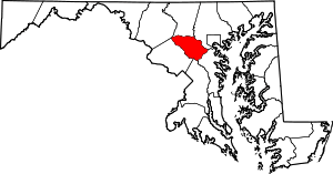 | |
| Villages | ||
| Unincorporated communities |
| |
| Footnotes | ‡This populated place also has portions in an adjacent county or counties | |
| Rank | Name | County | Pop. | ||||||
|---|---|---|---|---|---|---|---|---|---|
 Baltimore  Columbia |
1 | Baltimore | Independent city | 620,961 |  Germantown .jpg) Silver Spring | ||||
| 2 | Columbia | Howard | 99,615 | ||||||
| 3 | Germantown | Montgomery | 86,395 | ||||||
| 4 | Silver Spring | Montgomery | 71,452 | ||||||
| 5 | Waldorf | Charles | 67,752 | ||||||
| 6 | Glen Burnie | Anne Arundel | 67,639 | ||||||
| 7 | Ellicott City | Howard | 65,834 | ||||||
| 8 | Frederick | Frederick | 65,239 | ||||||
| 9 | Dundalk | Baltimore | 63,597 | ||||||
| 10 | Rockville | Montgomery | 61,209 | ||||||