Elk Creek (West Virginia)
| Elk Creek | |
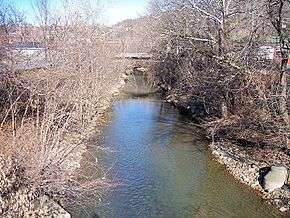 Elk Creek in Clarksburg in 2006 | |
| Country | United States |
|---|---|
| State | West Virginia |
| Counties | Barbour, Harrison |
| Source | |
| - location | Barbour County, West Virginia |
| - elevation | 1,535 ft (468 m) [1] |
| - coordinates | 39°06′32″N 80°08′07″W / 39.10889°N 80.13528°W [2] |
| Mouth | West Fork River |
| - location | Clarksburg, West Virginia |
| - elevation | 922 ft (281 m) [2] |
| - coordinates | 39°16′55″N 80°21′06″W / 39.28194°N 80.35167°WCoordinates: 39°16′55″N 80°21′06″W / 39.28194°N 80.35167°W [2] |
| Length | 29 mi (47 km) |
| Basin | 121 sq mi (313 km2) |
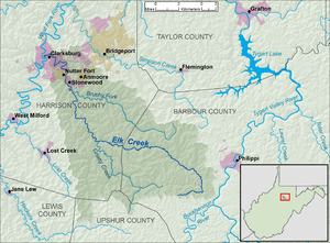 Elk Creek and its watershed | |
Elk Creek is a tributary of the West Fork River, 29 miles (47 km) long,[3] in north-central West Virginia in the United States. Via the West Fork, Monongahela and Ohio Rivers, it is part of the watershed of the Mississippi River, draining an area of 121 square miles (310 km2)[4] on the unglaciated portion of the Allegheny Plateau. The stream is believed to have been named by an 18th-century trapper and hunter named John Simpson, who encountered herds of elk along the stream.[5]
Elk Creek rises approximately 6 miles (9.7 km) southwest of Philippi in western Barbour County and flows generally west-northwestwardly into Harrison County, where it passes through the communities of Stonewood and Nutter Fort; it flows into the West Fork River in the city of Clarksburg.[6]
According to the West Virginia Department of Environmental Protection, approximately 70% of Elk Creek's watershed is forested, mostly deciduous. Approximately 22% is used for pasture and agriculture, and approximately 3% is urban.[4]
See also
References
- ↑ Google Earth elevation for GNIS source coordinates. Retrieved on 2007-02-12.
- 1 2 3 Geographic Names Information System. "Geographic Names Information System entry for Elk Creek (Feature ID #1538618)". Retrieved 2007-02-12.
- ↑ United States Environmental Protection Agency. "Watershed Assessment, Tracking & Environmental Results: Assessment Summary for Reporting Year 2008, West Virginia, West Fork Watershed". Archived from the original on 2011-10-13. Retrieved 2011-10-13.
- 1 2 West Virginia Department of Environmental Protection. "Watershed Atlas Project.". pp. West Fork River. Archived from the original on 2005-04-04. Retrieved 2007-02-26.
- ↑ Kenny, Hamill (1945). West Virginia Place Names: Their Origin and Meaning, Including the Nomenclature of the Streams and Mountains. Piedmont, West Virginia: The Place Name Press. p. 225.
- ↑ DeLorme (1997). West Virginia Atlas & Gazetteer. Yarmouth, Maine: DeLorme. pp. 25, 36. ISBN 0-89933-246-3.