Elizabeth Islands
| The Elizabeth Islands |
|---|
 |
| Major Islands listed in order from east to west |
| Nonamesset Uncatena Naushon Pasque Nashawena Penikese Cuttyhunk |
| Minor Islands: |
| Bachelor Baret Bull Cedar Gosnold Gull Rock Veckatimest Weepecket Islands |
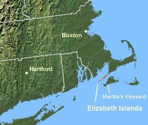
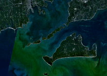
The Elizabeth Islands are a chain of small islands extending southwest from the southern coast of Cape Cod, Massachusetts in the United States. They are located at the outer edge of Buzzards Bay, north of Martha's Vineyard from which they are separated by Vineyard Sound, and constitute the town of Gosnold, Massachusetts in Dukes County. All of the Elizabeth Islands except Cuttyhunk and Penikese are privately owned by the Forbes family.[1]
The islands were claimed by England and named after Queen Elizabeth I.[2] In 1641, Thomas Mayhew the Elder of Watertown, Massachusetts, bought the islands (along with Nantucket and Martha's Vineyard) from William Alexander, the Earl of Sterling. The first known European inhabitant was Francis Usselton, who was banished for making secret trades with the local Indians without consent from the governor at the time. Before the creation of the Province of Massachusetts Bay in 1691, the islands were part of the extinct Dukes County, New York. The total land area of the islands is 34.55 km² (13.34 sq mi) and there was a permanent population of 75 persons as of the 2010 census.
Named islands
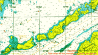
Stretching south-west from land's end at Falmouth, Massachusetts, the islands are:
- Nonamesset Island, the closest to the mainland
- Veckatimest, a small island.
- Uncatena Island, uninhabited as of the 2000 Census
- Naushon Island, 5.5 miles (8.9 km) long and the largest. Composed of the main island and small uninhabited Bull Island. Owned by the Forbes' Naushon Island Trust, and while it is not generally open to the public, the Forbes family has set aside Tarpaulin Cove to the south and Kettle Cove to the north as well as Bull Island and Hadley's Harbor to the northeast for public enjoyment including picknicking.
- The Weepecket Islands, three small, publicly accessible islands north of central Naushon owned by the Forbes family. These islands offer very few places to land, are nearly obscured by water, and are home to numerous shore birds, seals and other animals.
- Pasque Island, 1.5 miles (2.4 km) long, owned by a subset of the Forbes family, and covered in poison ivy. A shallow tidal creek cuts part way through the island.
- Nashawena Island, 3 miles (4.8 km) long, owned by another subset of the Forbes family, it has grazing livestock.
- Penikese, located about 0.5 miles (0.80 km) north of Nashawena and Cuttyhunk. Penikese is owned by the Commonwealth of Massachusetts and has a colorful history. It was the site of a groundbreaking 19th-century research facility that was the precursor to the famed Marine Biological Laboratory (MBL) in Woods Hole, was the site of the state's only leper colony in the early 20th century, and is currently a bird sanctuary and site of the Penikese Island School, an innovative, 35-year-old school for troubled teens.
- Cuttyhunk, farthest west in the chain, and home to most of Gosnold's municipal population. Like Penikese, Cuttyhunk is not owned by the Forbes family, and therefore much of the island is publicly accessible.
Named channels and harbors
Channels with strong tidal currents, known locally as holes, separate the islands from each other and the mainland. Currents of up to 6 knots (11 km/h) are driven by the different sizes and filling rates of Vineyard Sound to the southeast and Buzzards Bay to the northwest. At high tide, water flows from Buzzards Bay to the Vineyard Sound. Near mid-tide the water stops and reverses, filling the Bay at low tide.
Listed in order away from Falmouth, the named channels are:
- Woods Hole separating the mainland from Nonamesset Island
- Robinson's Hole between Naushon Island and Pasque Island
- Quick's Hole between Pasque Island and Nashawena Island
- Canapitsit Channel between Nashawena Island and Cuttyhunk Island.
Cuttyhunk Harbor is sheltered on its east by Nashawena Island on its west by Cuttyhunk Island and on its north by Penikese Island.
References
- ↑ Gabel, Sue. "The Elizabeth Islands". USA Today. Retrieved 2015-07-26.
- ↑ "Visiting the Elizabeth Islands," North American Review 5 (15) (Sept 1817), 313-324 (accessed July 7, 2009)
External links
| Wikisource has the text of the 1905 New International Encyclopedia article Elizabeth Islands. |
- Cuttyhunk Historical Society, the Museum of the Elizabeth Islands The purpose of the Cuttyhunk Historical Society is to preserve the traditions, records and history of the Elizabeth Islands for the benefit of present and future generations.
- Bathymetry of the Waters Surrounding the Elizabeth Islands, Massachusetts United States Geological Survey
 "Elizabeth Islands". The American Cyclopædia. 1879.
Coordinates: 41°28′30″N 70°46′00″W / 41.475°N 70.7667°W