Eldgjá
| Eldgjá | |
|---|---|
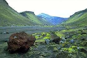 Canyon floor of Eldgjá | |
| Highest point | |
| Elevation | varies: canyon to 800 metres (2,625 ft) |
| Listing | List of volcanoes in Iceland |
| Coordinates | 63°58′00″N 18°36′33″W / 63.96667°N 18.60917°WCoordinates: 63°58′00″N 18°36′33″W / 63.96667°N 18.60917°W |
| Geography | |
 Eldgjá Location in Iceland | |
| Location | Iceland |
| Geology | |
| Mountain type | Fissure vents of Katla |
| Last eruption | 934 |
Eldgjá (Icelandic pronunciation: [ˈɛltcau], "fire canyon") is a volcano and a canyon in Iceland. Eldgjá and the Katla volcano are part of the same volcanic system in the south of the country.
Situated between Landmannalaugar and Kirkjubæjarklaustur, Eldgjá is the largest volcanic canyon in the world, approx. 40 km long, 270 m deep and 600 m wide at its greatest. It was discovered by Þorvaldur Thoroddsen in 1893. The first documented eruption in 934 was the largest flood basalt in historic time. The areal extent of the lava is around 800 km2.[1] An estimated 18 km3 of magma poured out of the earth.[2]
There is a waterfall named Ófærufoss within the canyon. A natural bridge across the waterfall vanished in 1993 due to excess water from melting ice.
The northern part of Eldgjá, including Ófærufoss, and surrounding areas, have been a part of Vatnajökull National Park since 2011.[3]
See also
- Geography of Iceland
- Glacial lake outburst flood
- Iceland hotspot
- Iceland plume
- List of glaciers of Iceland
- List of lakes of Iceland
- Timeline of volcanism on Earth
- Volcanology of Iceland
References
- ↑ Árni Hjartarson 2011. Víðáttumestu hraun Íslands. (The Largest Lavas of Iceland). Náttúrufræðingurinn 81, 37-49.
- ↑ "Katla: Eruptive History". Global Volcanism Program. Smithsonian Institution.
- ↑ "Ósnortin víðerni og einstakar jarðmyndanir" (in Icelandic). Ministry for the Environment and Natural Resources. 29 July 2011. Retrieved 24 March 2014.