Postal addresses in the Republic of Ireland
In Ireland, rural addresses are specified by the county, nearest post town, and the townland. Urban addresses are specified by county, city or town name, street name, house number or name, and apartment or flat number where relevant. 35% (over 600,000) Irish premises have non-unique addresses due to an absence of house numbers or names.[1] In smaller towns and many townlands, this requires postal workers to remember which family names correspond to which house.
For this reason, a postal code system called Eircode was launched in April 2014. Eircode suffixes an identifier that is unique to each premises. The system was criticised at its launch for its estimated ten-year cost of €27 million, omissions and inaccuracy, in addition to not being immediately available with satnav systems or Google Maps.[2]
However, since September 2016 the system is available on Google maps.[3]
Responsibility for the current postal delivery system rests with An Post, a semi-state body; however, the Department of Communications, Energy and Natural Resources (DCENR) retains the right to regulate addresses if they wish so.
Pre-Eircode postal districts
Dublin
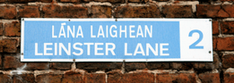
In Dublin city and its suburbs, a system of postal districts was introduced in 1917 by the Royal Mail with the prefix "D", and retained after Ireland became an independent country, without the prefix. However the use of district numbers by the public did not begin until 1961,[4] when street signs displayed postal district numbers. Prior to that time, street signs only displayed the street name in Irish and English.
The Dublin system had 22 districts - Dublin 1, 2, 3, 4, 5, 6, 6W, 7, 8, 9, 10, 11, 12, 13, 14, 15, 16, 17, 18, 20, 22, 24. These were incorporated into the new routing keys now being used with the Eircode national postcode system as D01, D02, D12, D22, etc.
Cork
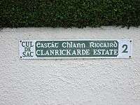
Clanrickarde Estate is in Cork 2.
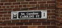
In Cork, there are also numbered districts, e.g.: the 'PATRICK STREET' (Sráid Phádraig) sign will display the digit '1', but these are not encountered in postal addresses. Cork has four postal districts. District 1 covers the city centre and large parts of the surrounding city. District 2, administered from the Ballinlough sorting office, covers the south-east, District 3 (from Gurranabraher) covers the north-west while District 4 (from Togher sorting office) covers the south-west. In practice, these numbers are used only internally by An Post and rarely used on mail. The numbers are not used in the new Eircode system.
Eircode
The launch of a national postcode system (Eircode, Irish equivalent for eircode: éirchód[5]) in Ireland began on 28 April 2014.[6] The system incorporates the existing numbered Dublin postal districts as part of the new code.[7][8] According to the government the new system made Ireland the first country in the world to have a unique postcode for each address (without requiring the use of building numbers).[9]
The codes, known as "Eircodes", consist of seven characters. The first three characters, called the "Routing Key", are designed to benefit the postal and logistics industry and contain on average 15,000 addresses each. The Routing Key is used to help sort mail, however it is not directly linked to counties, towns, or geographic features. The second part of the Eircode, called the "Unique Identifier," consists of four characters drawn from a carefully selected set of randomised letters and numbers that identify each individual address. They are stored in a central database, Eircode Address Database (ECAD), along with other useful geographic information including addresses, variants/aliases, and geo-coordinates of each address point.[10] Sample product data and pricing details were issued to businesses in March 2015. The ECAD is now available to licence by end-users and value-added resellers called Eircode Providers [11]
An example of a typical Irish address is that of the Lord Mayor of Dublin:[12] The Eircode is added on as an extra line to the existing address and postal district code which remains unchanged.[13]
Dublin City Council,
Lord Mayor’s Office,
Mansion House,
Dawson Street,
Dublin 2.
D02 AF30
Unlike other postcode systems, Eircode is not used for PO Box addresses.[14]
Background
An Post did not introduce automated sorting machines until the 1990s. By then, the optical character recognition (OCR) systems were advanced enough to read whole addresses, as opposed to just postcodes, thereby allowing An Post to skip a generation. Consequently, mail to addresses in the rest of the state did not require any digits after the address.
While An Post stated that the addressing system and sorting technologies make postcodes for mail delivery unnecessary, it was suggested that other services (such as advertising mail providers) would benefit from a national system.[15][16] After considerable delays, it was announced on 8 October 2013 that codes would be introduced by Spring 2015.[17] A ten-year contract to introduce and implement the postcode system was awarded to Capita Business Support Services Ireland in January 2014 with support from BearingPoint, AutoAddress and Strand Communications.[18][19]
Introduction of a national system
In 2005 it became the policy of the Government of Ireland to introduce a national scheme of postcodes.
In May 2005, Noel Dempsey, the Minister for Communications announced that postcodes would be introduced by 1 January 2008,[20] His successor as minister, Eamon Ryan, announced in August 2007 that he was delaying the project pending additional consultation and investigation into the need.[21] However, on 24 February 2008, The Sunday Times reported that Ryan was finalising the system and hoped to bring the plans to cabinet before the summer of 2008, for introduction in 2009.[22]
An Post was quoted as saying "it would be at the heart of the introduction"[22] and the report of PA Consultants indicated that An Post should be paid over €27 million for its involvement.[23]
Following further delays, in September 2009 the cabinet agreed to go ahead with the project. It was to be put out to tender with the end of 2011 given as the date by which postcodes should be assigned.[24] In January 2010 Minister Ryan stated in the Dáil that the exact nature of the code would not be decided until the implementation tender process had been completed but that a Location Code with GPS coordinates should be part of the system implemented.[25] On 29 January 2010, a tender to select consultants to assist the Minister for Communications in deciding on the way forward was issued.[26]
The project was again delayed, but in December 2010 the government agreed to seek tenders for procurement of national postcodes, with an estimated cost of €15 million, with the contract to be awarded in the summer of 2011 with the codes introduced by the end of that year.[27] According to the Pre-Qualification Questionnaire the contract was to have been awarded in August 2011, with work to begin on 1 September.[28] The Department published an update in September 2011, however, that the "procurement milestones given in the PQQ are indicative. The procurement process is still ongoing."[29]
On 29 June 2013 The Irish Times reported that the Minister for Communications, Energy and Natural Resources, Pat Rabbitte, was to bring details to the cabinet meeting of 2 July. According to the report, a postcode operator was to be appointed by September 2013 and every householder and business was to be issued a code by July 2014.[17] Following a cabinet meeting on 8 October 2013 Rabbitte announced that a unique seven-character code would be assigned to every post-box in the state. A consortium led by Capita Ireland had been awarded the tender to develop, implement and operate the system, costing €27 million.[8]
Language concerns
Conradh na Gaeilge, an organisation advocating use of the Irish language, has expressed concern over postcodes or postal abbreviations being based solely on English language place names, e.g. D for Dublin (Baile Átha Cliath in Irish) or WX for Wexford (Loch Garman in Irish) as is the case with vehicle registration plates. It has advocated that postcodes should either consist solely of numbers, as in many other bilingual countries, or be based on Irish language names instead.[30]
These concerns were addressed with the adoption of Eircodes. Apart from Dublin Eircode routing keys which use the initial letter D, the initial letters assigned to Eircode routing key areas bear no relation to either the English language or Irish language place names within the routing key areas.
According to the Eircode website (www.eircode.ie/faqs) "The first letter of the Eircode will not be linked to a county or city, (with the exception of Dublin where the Dublin districts codes have been in place for many years) as the Eircode design is not based on county boundaries and is language neutral."
Preparation for a postcode
In the light of the liberalisation of postal services and the end of An Post's monopoly, ComReg, the Communications Regulator in Ireland, began considering the introduction of postcodes. A Postcode Working Group met in early 2005 and produced a report[31] recommending the implementation of a postcode system.
On 23 May 2005, the Minister for Communications, Noel Dempsey, in a government press release[32] announced that postcodes would be introduced in Ireland by 1 January 2008. In November 2005, the National Statistics Board issued a report welcoming the decision[33] and making recommendations as to its implementation. They supported a point-based postcode system that used grid reference/GPS technology to provide a relatively clear-cut, low cost approach to allocating a postcode to an address. This avoids trying to group households together into small area clusters. It was later announced that the postcodes would include the one- or two-character county codes currently used in vehicle registration plates, making them alphanumeric,[34] with the existing Dublin system retained.[35]
In June 2007, a brief[36] to the new Minister for Communications, Eamon Ryan, stated that a memo was submitted by the Department of Communications to the Irish Government in May 2007 seeking approval for the implementation of the postcode system. It also stated that the decision arising from this submission was that the Minister would revert to Government following further analysis to quantify the benefits, which would then be followed by a public consultation process. However, in August 2007, the Minister[37] reportedly postponed the implementation of the system "indefinitely" pending additional public consultation.
On 18 October 2007 Eamonn Ryan announced at ComReg's "Postal Services in the 21st Century" conference that "[Post] codes should be introduced as a matter of priority". The introduction was stated to be subject to cabinet approval.[38] On 25 February 2008 the Irish Independent reported that the proposals were being presented to the Cabinet with a view to full national implementation before summer 2008. It stated that Eamon Ryan was finalising the proposals, which include a 6 character format postcode, giving a sample of "D04 123" where "D04" corresponds to the current Dublin 4 postal region and "123" is a specific group of buildings.[39] similar to British and Dutch postcodes, which cover groups of buildings, rather than simply suburbs or towns.
On 7 December 2008, the Sunday Business Post reported results of an independent report by PA Consulting for the Department indicating that benefits of up to €22m could be achieved for public bodies through the introduction of a postcode. The PA report indicated that postcodes had greater uses beyond the delivery of mail or simple navigation services, citing the "need for efficient database based on postcodes reducing inefficient service delivery and infrastructural planning". It said that Postcodes are considered critical for "efficient spatial planning and aiding health research, education, housing social care and employment integration". Increased efficiencies for businesses would emerge; in particular, the insurance sector stated that "it would result in annual savings of around €40 million by improving their risk management assessments."[40]
The article concluded saying that annual maintenance costs for a postcode management licence holder which would include maintaining the necessary database of buildings are estimated "at about €2.5 million" but the minister was reported as saying that "ongoing costs would be covered by income generated by the eventual licence holder".[40]
On 20 September 2009 RTÉ reported that tenders for the design and implementation of the system will be issued shortly and that the system will be, according to the Minister for Communication, comprising digits and letters and be introduced in 2011. Minister Ryan said the cost would be a fraction of the €50 million cost estimated four years previously.[41] The Communication Workers Union claimed that the new system could not be introduced by 2011, and that An Post would have to develop a whole new type of software to make its machinery read the new postcodes.[42] However, in a Seanad debate on 21 October 2009, the Minister reiterated that the proposed new system would be introduced by early 2011 at the latest.[43] Liz McManus, opposition spokeswoman for communications in the Labour Party, has since called for the plan to be revoked due to job losses in An Post, the projected costs and fears of junk mail.[44]
In Dail question time on 2010-01-26, Simon Coveney challenged Minister Eamon Ryan's apparent rejection of a GPS based postcode system. Eamon Ryan refuted this saying that he fully supported a postcode system that had geo-coordinates at its centre. The system chosen would depend on the tenders received. Coveney pointed out that a system that pinpointed 20–50 houses would only slightly improve what is there at present and would be of little help to an ambulance, a courier or a postman that does not know the area.
On 1 February 2010 the tender process to select consultants was announced, with a view to having the postcode system operational by the end of 2011.[45]
In April 2010, the Oireachtas Committee on Communications, Energy and Natural Resources published a report criticising some of the proposals listed above, recommending instead that any postcode implemented must be capable of supporting "developing technologies such as internet mapping, google maps and iPhones", applying a unique identifier to each property. It suggests that the previously mentioned D04 123 model will not satisfy this requirement and may, in fact, make matters worse.[46][47][48]
On 15 April 2010 the tendering process to select a consultant to advise the Minister on the implementation of a postcode was cancelled.[49]
According to the Irish Independent a serious but unspecified technical error in the tendering documents led to the cancellation of the tender issued in February 2010.[50]
Legislation
Legislation to "provide for the establishment, operation and maintenance of a system of postcodes" – the Communications Regulation (Postal Services) Bill 2010 – was introduced in November 2010.[51] The bill was enacted in August of the following year, with Part 3 of the act dealing with the establishment of a National Postcode System.[52] Postcodes are defined in the legislation as "a code consisting of numbers or other characters or both numbers and other characters that identifies the locality of an address and, where appropriate, the geographic location of an address". The Minister for Communications, Energy and Natural Resources is empowered to award a contract for "the development, implementation and maintenance of a system... for the allocation, dissemination and management of postcodes for the purposes of, or relating to, the provision of postal services and the use of the national postcode system by other persons for such other purposes as the Minister considers appropriate".[53]
On 29 June 2013 The Irish Times reported that the Minister for Communications, Energy and Natural Resources, Pat Rabbitte, was to bring details to the cabinet meeting of 2 July. According to the report, a postcode operator was to be appointed by September 2013 and every householder and business was to be issued a code by July 2014.[17] Following a cabinet meeting on 8 October 2013 Rabbitte announced that a unique seven-digit would be assigned to every post-box in the state. A consortium led by Capita Ireland had been awarded the tender to develop, implement and operate the system, at a cost of €27 million over a ten-year period.[8] On the roll-out day in July 2015, householders and businesses were able to look them up online in advance of receiving a posted notification. The Eircode website received over 1.5 million hits in the first 48 hours.
Each code consists of seven letters and/or digits, in the format A65 B2CD. The first three characters represent one of 139 geographical district or post-towns. The existing Dublin postal districts form the first three characters in the new system.[7][8]
List of Eircode routing keys
The following is a list of Eircode routing keys:
| Routing Key | Region |
|---|---|
| A41 | Ballyboughal |
| A42 | Garristown |
| A45 | Oldtown |
| A63 | Greystones |
| A67 | Wicklow |
| A75 | Castleblayney |
| A81 | Carrickmacross |
| A82 | Kells, Kingscourt, Virginia |
| A83 | Enfield, Summerhill |
| A84 | Ashbourne |
| A85 | Dunshaughlin, Ratoath |
| A86 | Dunboyne |
| A91 | Dundalk |
| A92 | Drogheda, Ardee |
| A94 | Blackrock, Monkstown, Booterstown |
| A96 | Dún Laoghaire, Dalkey, Sallynoggin, Glenageary |
| A98 | Bray, Kilmacanogue |
| C15 | Trim, Navan, Athboy |
| D01 | Dublin 1 |
| D02 | Dublin 2 |
| D03 | Dublin 3 |
| D04 | Dublin 4 |
| D05 | Dublin 5 |
| D06 | Dublin 6 |
| D6W | Dublin 6W |
| D07 | Dublin 7 |
| D08 | Dublin 8 |
| D09 | Dublin 9 |
| D10 | Dublin 10 |
| D11 | Dublin 11 |
| D12 | Dublin 12 |
| D13 | Dublin 13 |
| D14 | Dublin 14 |
| D15 | Dublin 15 |
| D16 | Dublin 16 |
| D17 | Dublin 17 |
| D18 | Dublin 18 |
| D20 | Dublin 20 |
| D22 | Dublin 22 |
| D24 | Dublin 24 |
| E21 | Cahir |
| E25 | Cashel |
| E32 | Carrick - on - Suir |
| E34 | Tipperary |
| E41 | Thurles, Templemore |
| E45 | Nenagh |
| E53 | Roscrea |
| E91 | Clonmel, Fethard |
| F12 | Knock, Swinford, Claremorris |
| F23 | Castlebar |
| F26 | Ballina, Bangor |
| F28 | Westport, Achill |
| F31 | Ballinrobe |
| F35 | Ballyhaunis |
| F42 | Roscommon |
| F45 | Castlerea, Glenamaddy |
| F52 | Boyle |
| F56 | Ballymote |
| F91 | Sligo, Manorhamilton, Tubbercurry |
| F92 | Letterkenny |
| F93 | Lifford, Carndonagh |
| F94 | Bundoran, Donegal |
| H12 | Cavan |
| H14 | Belturbet |
| H16 | Cootehill |
| H18 | Monaghan |
| H23 | Clones |
| H53 | Ballinasloe, Portumna |
| H54 | Tuam |
| H62 | Loughrea |
| H65 | Athenry |
| H71 | Clifden |
| H91 | Galway, Spiddal, Headford, Ballyvaughan |
| K32 | Balbriggan |
| K34 | Skerries |
| K36 | Malahide, Donabate |
| K45 | Lusk |
| K56 | Rush |
| K67 | Swords |
| K78 | Lucan |
| N37 | Athlone, Moate |
| N39 | Longford, Ballymahon, Granard, Lanesborough |
| N41 | Carrick On Shannon |
| N91 | Mullingar, Kinnegad |
| P12 | Macroom |
| P14 | Crookstown |
| P17 | Kinsale |
| P24 | Cobh |
| P25 | Midleton |
| P31 | Ballincollig |
| P32 | Rylane |
| P36 | Youghal |
| P43 | Carrigaline |
| P47 | Dunmanway |
| P51 | Mallow, Rathcormac, Cappoquin |
| P56 | Charleville |
| P61 | Fermoy, Rathcormac |
| P67 | Mitchelstown |
| P72 | Bandon |
| P75 | Bantry, Glengarriff |
| P81 | Skibbereen, Baltimore |
| P85 | Clonakilty, Rosscarbery |
| R14 | Athy |
| R21 | Muine Bheag/Bagenalstown |
| R32 | Portlaoise, Abbeyleix, Portarlington |
| R35 | Tullamore |
| R42 | Birr, Banagher |
| R45 | Edenderry |
| R51 | Kildare |
| R56 | Curragh |
| R93 | Carlow, Tullow |
| R95 | Kilkenny, Graiguenamanagh, Thomastown |
| T12 | Cork city southside, Mahon, Passage West |
| T23 | Cork city northside, Hollyhill |
| T34 | Carrignavar |
| T45 | Glanmire, Carrigtwohill |
| T56 | Watergrasshill |
| V14 | Shannon |
| V15 | Kilrush, Kilkee |
| V23 | Caherciveen |
| V31 | Listowel |
| V35 | Kilmallock |
| V42 | Newcastle West |
| V92 | Tralee, Dingle |
| V93 | Kenmare, Killarney |
| V94 | Limerick, Abbeyfeale, Newport, Killaloe |
| V95 | Miltown Malbay, Ennis, Kildysart |
| W12 | Newbridge |
| W23 | Maynooth, Celbridge, Leixlip |
| W34 | Monasterevin |
| W91 | Naas, Blessington |
| X35 | Dungarvan |
| X42 | Kilmacthomas, Bunmahon |
| X91 | Waterford, Dunmore East, Tramore |
| Y14 | Arklow |
| Y21 | Enniscorthy, Bunclody |
| Y25 | Gorey |
| Y34 | New Ross, Fethard - on - Sea |
| Y35 | Wexford, Rosslare |
Issues with Eircode
An Post's position
An Post had previously claimed that a nationwide public postcode system was unnecessary, stating that it was "a 1960s solution to a 21st century problem",[54] that it would be expensive, and that its existing system was superior.[55] However, they later became actively involved in implementing the new Eircode system, with their CEO saying they were investing in their four main sorting centres to adopt the new postcode system at a cost of €1m, according to an Irish Times report stating "An Post chief executive Donal Connell said it would work "very closely" with Eircode, the new company set up by Capita to manage the codes, in implementing the national infrastructure. "It will certainly help with the efficiency of our distribution'. Mr Connell said €1 million from An Post’s capital investment fund would be spent to install new software in its four national sorting centres.[56][57][58] Courier services and advertising mail companies complained that the absence of such a system put Ireland at a disadvantage compared with other European countries.[55]
An Post did, however, use a system of three-digit sort codes, similar to the Mailsort system used by Royal Mail in the United Kingdom, for pre-sorting mail in bulk.[59] There were two levels, Presort 152, which had 152 codes for large volumes of mail,[60] and Presort 61, which had 61 codes for smaller volumes.[61]
It corresponded to Dublin postal districts, e.g.; Dublin 1 is 101, etc., except for Dublin 10 and Dublin 20, both of which had the same code 110, and Dublin 6W, which was 126. Cork had codes for four each of the delivery offices, Ballinlough (901), North City (902), Little Island (903), and South City (903).
Other issues
The Eircode system has been criticised for using an unsequenced code limited to postal addresses on the grounds that this undermines the systems utility.[62][63] The cost, procurement methods used, slow rollout and implementation of the system (originally proposed in 2003) was criticised, including in a report by the Comptroller and Auditor General.[64][65]
Other main criticisms proposed by its rivals include no meaningful testing, being database- rather than algorithm-driven, only being available for permanent buildings, limited use for emergency services, being unusable by utility companies, local authority infrastructure, and transport company infrastructure.[65]
Unofficial postcodes
In the absence (until recently) of an official postcode system various unofficial systems have emerged in recent years.
The GeoDirectory
Established by the state owned post office, An Post, and the Ordnance Survey of Ireland, the Geodirectory, is a widely used database of every building in the Republic of Ireland.[66] Each is listed with an address, the District Electoral Division (a grouping of addresses useful for analysis and defining catchment areas of services), a system GeoCode (not in use by individuals), and the precise location coordinates. In the absence of postcodes it is perhaps the default system for marketing and address validation in Ireland as well as being the addressing system for the post office. It is available for commercial use and has been used by several commercial companies for various geo-location and data cleansing purposes.[67] It is also used by Google Maps in Ireland to identify and search for building names on mapping.[68] For example, one of the entries in its sample database[69] is Midland Regional Hospital, Portlaoise, building ID 10003105 (at ITM 648555.822, 698833.088). The GeoDirectory was used as the basis for developing the new Eircode Database with its addresses and associated geocoordinates.
GO Code
The GO (ge-o) Code was developed by Go Code Ltd. in Dublin, 2007. It is a multi-character alphanumeric code calculated from latitude and longitude that varies final accuracy according to the number of characters used. The Ireland version uses 7-characters giving an accuracy of 5 metres squared.[70] The equivalent code for the Midland Regional Hospital, as above, is KHG RT76. It was adopted by TomTom for use on its various satnav models in 2010 and GO Code was the first to develop a location code app on the i-Phone App Store. The code design allows for greater or lesser granularity with the addition or subtraction of characters from the end of the code. The company has also been developing Go Code designs for use in other countries, including India, (9-characters) where it is being piloted within the slums in Kolkata, to help bring essential health, education and social services to the people living there.[71] GO Code brought together the companies in the winning tender, including Capita, BearingPoint, and AutoAddress.
Loc8 Code
The Loc8 Code was developed by GPS Ireland Ltd. and field tested with Garmin in 2008. It is now owned and managed by Loc8 Code Ltd. in Cork. It is an 8 character alphanumeric code calculated from latitude and longitude to an accuracy of within 6 metres in any direction. It includes a checksum character.[72][73][74][75] The equivalent code for the Midland Regional Hospital is RFT-41-M46.
- Loc8 algorithm
The Loc8 algorithm is closed source, meaning that Loc8 codes can only be generated by visiting the myloc8ion com website, and can only be resolved to longitude and latitude by software manufactured under a licence supplied by GPS Ireland. Permission is automatically granted to communicate individual codes, but not lists of codes without prior discussion. Furthermore, the licence conditions prohibit any third party from reverse-engineering the algorithm.[76]
According to information publicly disclosed by GPS Ireland,[77] the Loc8 code consists of at least three discrete parts, each of which imparts increasing accuracy of the location.
To take the above example of the Midland Regional Hospital, 'RFT-41-M46', 'R' corresponds to an area approximately 90 km square. 'FT' defines an area approximately 3.5 km square within that area. 'M4' corresponds to an area about 120 m square within the area demarcated by 'RFT'; and the '6' is a checksum. The remaining component, '41', defines a box within the 120 m square area, with sufficient accuracy to pin-point the front door of a building. The Loc8 codes 'RFT-M46' and 'RFT' are both valid, with the caveat that they refer to progressively larger areas rather than a specific location, and that the user must understand the inherent limitations.
Furthermore, the letters H, I, O and U never appear in the code. The letter C is never used as the first letter of the code; whereas, the letter G only ever appears as a first character. The letters A and E only appear when their presence would not lead to a word being spelled. The middle two characters are always numeric. The letters 'BT' are designed to never occur at the beginning of a Loc8 code, avoiding confusion with Royal Mail postcodes for Northern Ireland, which all begin with those two letters.[78]
OpenPostcode
The OpenPostcode is an opensource project under development since 2011. It is a variable length alphanumeric code calculated using a free algorithm from latitude and longitude to an accuracy of within an average of 3 metres at 7 characters. An optional checksum is added. It is currently implemented in proprietary utility company systems. A proof of concept website[79] and Android app[80] are available.[81] An equivalent code for the Midland Regional Hospital is RK3P5 (the exact coordinates as listed in the GeoDirectory are RK3P5J5J).
OP grid
The Irish implementation of OpenPostcodes uses a grid extending from 55.5°N 10.75°W at its north west corner, and covering the whole of the island of Ireland and outlying islands such as Rathlin Island. The south east corner of the grid is just south of Skomer, west Wales, at 51.3°N 5.35°W.
Redesigned in 2015, version 4, as a spiral of its 25 characters starting with 2 in the bottom left and continuing clockwise to X in the middle, the grid has the following format:
| 6 | 7 | 8 | 9 | B |
| 5 | N | P | Q | C |
| 4 | M | X | R | D |
| 3 | L | W | T | F |
| 2 | K | J | H | G |
Each grid square is subsequently divided into a grid of the same format, and likewise for the resulting squares, until the required precision has been attained. For each subdivision, the resulting number or letter is added onto the geocode. X will always be the centre. The letter V has been removed (possibly looking too vowel-like) and replaced with B, which is now uppermost top-right so as to place any B codes firmly within the UK postcode area BT and avoid any confusion.
The algorithm however works with any combination of 25 characters, or more, as required. This specific grid is optimised for Ireland.
According to OpenPostcode.org Ireland,[82] the expected precision is as follows:
| Code length | Example code | Precision | Suggested use |
|---|---|---|---|
| 8 | D4TGHK5C | 1.25 m x 0.9 m | Identifying infrastructure such as utility poles |
| 7 | D4TGHK5 | 5.98 m x 4.6 m | Building entrances |
| 6 | D4TGHK | 30 m x 23 m | Small sites |
| 5 | D4TGH | 150m x 115 m | Larger sites and campuses |
| 4 | D4TG | 0.75 km x 0.57 km | Neighbourhoods |
| 3 | D4T | 3.7 km x 2.9 km | Collection of statistics on small areas |
| 2 | D4 | 19 km x 14 km | Identifying regions |
| 1 | D | 93 km x 72 km | Collection of statistics on larger areas of the country |
A checksum can be generated for codes of any length. Apart from helping to confirm that Irish OpenPostcodes have been entered accurately without errors such as juxtaposed letters and digits, it can be used to determine whether the code relates to Ireland, or to Hong Kong or Yemen, places for which similar geocodes are based, where the location-based checksum result will differ.
See also
References
- ↑ Eircodes are on the way to all addresses in Ireland, Department of Communications, Energy and Natural Resources
- ↑ "Eircode Q&A: things you need to know about the new system". The Irish Times. 13 July 2015. Retrieved 13 July 2015.
- ↑ http://www.newstalk.com/You-can-now-use-Eircode-to-find-places-on-Google-Maps[]
- ↑ It's in the postcode, "The Irish Independent," retrieved 26 September 2009
- ↑ "éirchód entry in tearma.ie".
- ↑ Dept of Communications (28 April 2014). "Minister Rabbitte launches Eircode the new location codes for Irish addresses". DCENR. Retrieved 2015-07-15.
- 1 2 "Unique postcodes for all households by 2015". RTÉ. 8 October 2013. Retrieved 8 October 2013.
- 1 2 3 4 Quann, Jack (8 October 2013). "Irish postcode system to be in place for 2015". Newstalk. Retrieved 8 October 2013.
- ↑ "Rabbitte gets green light from cabinet for "next generation postcode" system by 2015". Department of Communications, Energy and Natural Resources. 8 October 2013. Retrieved 2013-11-12.
- ↑ "Eircode website 25 Aug 2014". Eircode.ie. Retrieved 2015-07-15.
- ↑ "Archived copy". Archived from the original on 24 October 2016. Retrieved 2015-08-20.
- ↑ "Customer Services Centre". Dublin City Council. Retrieved 2015-07-15.
- ↑ What will get an Eircode? Archived 3 May 2016 at the Wayback Machine.
- ↑ Is there an Eircode associated with PO Box numbers? No, Eircodes are not being allocated to PO Box numbers at this time. Archived 24 October 2016 at the Wayback Machine.
- ↑ Laura Noonan (12 March 2006). "Postcode system will increase direct marketing". Sunday Business Post. Retrieved 10 February 2015.
- ↑ "Our minister for junk mail". Sunday Times. 27 September 2009. Retrieved 24 October 2009.
- 1 2 3 Minihan, Mary (29 June 2013). "Postcode system to be implemented within 18 months". The Irish Times. Retrieved 29 June 2013.
- ↑ O'Halloran, Marie (28 January 2014). "Rabbitte signs €26.5m national post code deal". The Irish Times. Retrieved 28 January 2014.
- ↑ John Kennedy (28 April 2014). "It's not a postcode, it's a smart code – Eircodes to go live in spring 2015". Siliconrepublic.com. Retrieved 2015-07-15.
- ↑ "Dempsey announces programme to introduce postcodes in Ireland by 1st January 2008 –". Department of Communications, Energy and Natural Resources. 23 May 2005. Retrieved 3 April 2009.
- ↑ "Minister to delay postcode system". Breakingnews.ie. 20 August 2007.
- 1 2 The Sunday Times (Irish Edition) 24 February 2008 p 3 —Ryan zeroes in on Dublin 4 by Stephen O'Brien
- ↑ "Building The Case For Postcodes 2008". Retrieved 12 April 2013.
- ↑ DCENR Press Release 31 Jan 2010 Archived 22 November 2010 at the Wayback Machine.
- ↑ "Dail Debate Jan 26th 2010". Kildarestreet.com. 26 January 2010. Retrieved 12 April 2013.
- ↑ "DCENR Tender For Consultant". Department of Communications, Energy and Natural Resources. 2015. Retrieved 2015-07-15.
- ↑ Harry McGee (4 January 2011). "Postcodes could be introduced across State by year's end". The Irish Times.
- ↑ "Pre-Qualification Questionnaire (PQQ) for the appointment of a Postcode Management Licence Holder (PMLH)". Department of Communications Energy and Natural Resources. January 2011. p. 5. Retrieved 16 October 2011.
- ↑ "Postcodes". Department of Communications, Energy and Natural Resources. Retrieved 16 October 2011.
- ↑ IRISH POSTCODES SHOULD BE IRISH-BASED, SAYS CONRADH NA GAEILGE Archived 11 March 2012 at the Wayback Machine., Conradh na Gaeilge, 11 November 2008
- ↑ An examination of the issues in relation to the introduction of a postcode in Ireland Archived 30 May 2008 at the Wayback Machine.; report of the Postcode Working Group (MS Word doc)
- ↑ "''Dempsey announces programme to introduce postcodes in Ireland by 1st January 2008". Department of Communications, Energy and Natural Resources. 23 May 2005. Retrieved 2015-07-15.
- ↑ Statistical and Policy Value of Postcodes Archived 14 October 2007 at the Wayback Machine. (MS Word, 30 K) – paper from National Statistics Board Archived 14 October 2007 at the Wayback Machine.
- ↑ McGee, Harry (14 August 2006). "All addresses to be given postcodes". The Irish Examiner. Thomas Crosbie Holdings. Retrieved 15 July 2015.
- ↑ Coyle, Colin (10 September 2006). "Upmarket Dublin survives postcode shake-up". The Times. News International. Archived from the original on 4 July 2012. Retrieved 17 April 2010.
- ↑ Introductory Brief for Mr. Eamonn Ryan T.D. Archived 30 May 2008 at the Wayback Machine. (PDF, 3 MB) Department of Communications, Energy and Natural Resources, 15 June 2007
- ↑ "Minister to delay postcode system". Breakingnews.ie. 2007-08-20. Retrieved 2015-07-15.
- ↑ Hancock, Ciarán (19 October 2007). "Minister keen to introduce postcodes". The Irish Times. Retrieved 12 February 2008.
- ↑ Heffernan, Breda (25 February 2008). "An Post signals end of the road for exclusive 'D4'". The Irish Independent. Independent News & Media. Retrieved 26 February 2008.
- 1 2 Connolly, Niamh (7 December 2008). "Postcode system could save public bodies €22m". Sunday Business Post. Thomas Crosbie Holdings. Archived from the original on 28 October 2009. Retrieved 21 January 2009.
- ↑ "National postcodes to be introduced". RTÉ News. 20 September 2009. Retrieved 20 September 2009.
- ↑ Rogers, Stephen (24 September 2009). "CWU: Postcode plan will be late, won't save money and will damage post office". The Irish Examiner. Thomas Crosbie Holdings. Retrieved 15 July 2015.
- ↑ "Seanad Éireann". Retrieved 15 December 2009.
- ↑ "McManus warns that postcodes won't deliver" (Press release). Irish Labour Party. 8 December 2009. Retrieved 6 January 2010.
- ↑ O'Halloran, Marie (1 February 2010). "Tender process for postal codes launched". The Irish Times. Archived from the original on 1 February 2010. Retrieved 17 April 2010.
- ↑ Baker, Noel (1 April 2010). "Hi-tech postcode system considered". The Irish Examiner. Thomas Crosbie Holdings. Retrieved 17 July 2015.
- ↑ "Much Remains to be Done if New Postcode System is to be Rolled out Smoothly-Oireachtas Committee Report" (Press release). Houses of the Oireachtas. 31 March 2010. Archived from the original on 7 April 2010. Retrieved 17 April 2010.
- ↑ "Joint Committee on Communications, Energy and natural Resources – Second Report – The Postcodes Report" (PDF). Houses of the Oireachtas. 31 March 2010. Retrieved 17 April 2010.
- ↑ "Project Management: Implementation of National Postcodes System". Department of Finance. 15 April 2010. Retrieved 17 April 2010.
- ↑ "Postcode rollout delayed again after technical glitch". Irish Independent. 17 April 2010. Retrieved 8 May 2010.
- ↑ "Communications Regulation (Postal Services) Bill 2010 [Seanad] Number 50 of 2010". Houses of the Oireachtas. Retrieved 25 January 2011.
- ↑ "Minister Rabbitte announces final step in opening the postal market to full competition". merrionstreet.ie. Irish Government News Service. 2 August 2011. Retrieved 4 September 2011.
- ↑ "Communications Regulation (Postal Services) Act 2011". Irish Statute Book. Attorney General of Ireland. Retrieved 4 September 2011.
- ↑ An Post View – Mr Derek Kickham ComReg Symposium on Postcodes 24 November 2003
- 1 2 "An Post is against codes plan". RTÉ News. 23 May 2005. Retrieved 17 April 2010.
- ↑ "McManus attacks plans for new Postcode system". The Irish Times. 5 January 2010. Retrieved 9 January 2010.
- ↑ Michael, Jason (21 September 2009). "New postal code system by 2011". The Irish Times. Retrieved 10 January 2010.
- ↑ Flaherty, Rachel (2014-04-29). "New Irish postcodes to be sent to 2.2m households in spring 2015". Irish Times. Retrieved 2015-07-15.
- ↑ An Post – Presort Lookup Archived 12 April 2009 at the Wayback Machine.
- ↑ An Post – Presort 152 Archived 19 November 2007 at the Wayback Machine.
- ↑ An Post – Presort 61 Archived 9 July 2009 at the Wayback Machine.
- ↑ Mullally, Una (2014-11-10). "Devil is in the detail of new postcode system". Irish Times. Retrieved 2015-07-15.
- ↑ Brian M. Lucey (14 April 2015). "13 things that are wrong with Eircode…". Brian M. Lucey. Retrieved 2015-07-15.
- ↑ League, Joe (30 September 2015). "C&AG report: Questions over value of €38m Eircode". Irish Examiner. Retrieved 15 November 2015.
- 1 2 "Eircodes….Get Lost !!!". Get Lost Eircodes. 2014-07-27. Retrieved 2015-07-15.
- ↑ "GeoDirectory". Retrieved 28 July 2012.
- ↑ "GeoDirectory Case Studies". Retrieved 21 July 2015.
- ↑ "Google Geo Developers Blog". Retrieved 3 August 2012.
- ↑ "GeoDirectory Downloads". Retrieved 29 July 2012.
- ↑ "GO Code". Retrieved 28 July 2012.
- ↑ "Address for Everyone". Mailing Systems Technology. 21 August 2013. Retrieved 2015-07-15.
- ↑ "Loc8 Code". Retrieved 28 July 2012.
- ↑ "Irish post code system launched". Retrieved 28 July 2012.
- ↑ "All-Ireland digital address code system goes live". Retrieved 28 July 2012.
- ↑ "Loc8 Codes for Ireland". Retrieved 28 July 2012.
- ↑ "Licensing Loc8 code services". Retrieved 16 November 2012.
- ↑ "Loc8 Code". Retrieved 16 November 2012.
- ↑ "Getting help with your Loc8 code". Retrieved 16 November 2012.
- ↑ "iemap.org". Retrieved 28 July 2012.
- ↑ "OpenPostcode App". Retrieved 28 July 2012.
- ↑ "OpenPostcode". Retrieved 28 July 2012.
- ↑ "iemap.org". Retrieved 17 November 2012.