Ehrmandale, Indiana
| Ehrmandale | |
|---|---|
| Unincorporated community | |
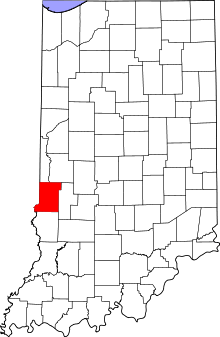 Vigo County's location in Indiana | |
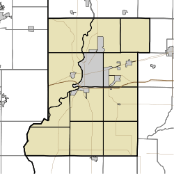 Ehrmandale location in Vigo County, Indiana | |
| Coordinates: 39°32′06″N 87°14′20″W / 39.53500°N 87.23889°WCoordinates: 39°32′06″N 87°14′20″W / 39.53500°N 87.23889°W | |
| Country |
|
| State |
|
| County | Vigo County |
| Township | Nevins Township |
| Elevation[1] | 181 m (594 ft) |
| ZIP code | 47805 |
| Area code(s) | 812 |
| GNIS feature ID | 434047 |
Ehrmandale is an unincorporated community in southern Nevins Township, Vigo County, Indiana, United States.[2]
It is part of the Terre Haute metropolitan area.
History
Ehrmandale was known as Elsie until 1898.[3] A post office was established under this name in 1896, was renamed Ehrmandale in 1898, and was discontinued in 1905.[4]
Geography
Ehrmandale is located at 39°32′06″N 87°14′20″W / 39.53500°N 87.23889°W at an elevation of 594 feet.
References
- ↑ "US Board on Geographic Names". United States Geological Survey. October 25, 2007. Retrieved 2016-07-14.
- ↑ "Ehrmandale, Indiana". Geographic Names Information System. United States Geological Survey. Retrieved 2010-06-24.
- ↑ "USGS detail on Ehrmandale - Variant Citation". Retrieved 2016-07-14.
- ↑ "Vigo County". Jim Forte Postal History. Retrieved July 14, 2016.
Municipalities and communities of Vigo County, Indiana, United States | ||
|---|---|---|
| City | ||
| Towns | ||
| Townships | ||
| CDPs | ||
| Other unincorporated communities |
| |
| Footnotes | ‡This populated place also has portions in an adjacent county or counties | |
This article is issued from Wikipedia - version of the 8/7/2016. The text is available under the Creative Commons Attribution/Share Alike but additional terms may apply for the media files.