Echilamvayal
| Echilamvayal ഏച്ചിലാംവയല് | |
|---|---|
| village | |
| Coordinates: 12°08′42″N 75°14′10″E / 12.145009°N 75.236077°ECoordinates: 12°08′42″N 75°14′10″E / 12.145009°N 75.236077°E | |
| Country |
|
| State | Kerala |
| District | Kannur |
| Government | |
| • Body | Payyanur Municipality |
| Languages | |
| • Official | Malayalam, English |
| Time zone | IST (UTC+5:30) |
| PIN | 670346 |
| Telephone code | 4985 |
| ISO 3166 code | IN-KL |
| Vehicle registration | KL-13 |
| Coastline | 4 kilometres (2.5 mi) |
| Nearest city | Payyanur |
| Sex ratio | 1:1 ♂/♀ |
| Literacy | 99% |
| Lok Sabha constituency | Kasargod |
| Civic agency | Payyanur Municipality |
| Climate | Tropical monsoon (Köppen) |
| Avg. summer temperature | 35 °C (95 °F) |
| Avg. winter temperature | 20 °C (68 °F) |
Echilamvayal is a village in the Kannur district of Kerala, India, located in the western side of Kallan Kunnu (Kallan Hill) on the Payyanur-Pulingome state highway.
Economy
Echilamvayal is primarily an agriculture area. Most of the farmers cultivate rice, coconut, arica nut, banana, and other plantation and horticulture crops.
Geography
The eastern side of Kallan Hill is primarily ghat areas and the south, north and western sides are agricultural lands. One of the tributaries of Perumba River (Payyanur) starts from this hill. The famous Kallan kulam (Kallan pond) is on the southern side of this hill. This pond is the home of many rarely found fishes. There are many small "Para kulam"s (hill ponds) on top of the Kallan joseph smith hill. Kallan hill is a natural sanctuary for many native animals and birds.
Landmarks
Echilamvayal Reading Room and Library, Anganavadi, AKG Center, Yuvajana Vedhi, and Hazmi Purogamana vedhi are the cultural organizations in this area. The Echilamvayal Mazjid and Palayinkeezhu Bhagavathi Temple are the two religious places for devotees. The coconut processing center is the only industrial unit in this area.
Administration
Echilamvayal is bordered by Karinkuzhi (north), Korom north (east), Payyanchal (south) and Vellur (west). It is about 3.5 km from the Payyanur town. Echilamvayal belongs to the Vellur of Payyanur Municipality.
Transportation
The national highway passes through Perumba junction. Goa and Mumbai can be accessed on the northern side and Cochin and Thiruvananthapuram can be accessed on the southern side. The road to the east of Iritty connects to Mysore and Bangalore. The nearest railway station is Payyanur on Mangalore-Palakkad line. Trains are available to almost all parts of India subject to advance booking over the internet. There are airports at Mattanur, Mangalore and Calicut. All of them are international airports but direct flights are available only to Middle Eastern countries.
History
Etymology and Geography
In the local language ‘Malayalam’, Vayal means paddy field. Prior to 1950, south, west, and north-west parts of Echilamvayal were having vast area of plain paddy fields. At that time, even coconut trees were not cultivated in this area. The only tree that was visible in the vast area of paddy land was a ‘Njanal’ tree about half a mile from the western tip of the Kallan hill. Prior to 1950, one could get an unobstructed view of Arabian Sea, Ezhimala hills, and Western Ghats from the top of Kallan hill. It is not clear how the Echilamvayal got ‘Achilam’. Some people believe that Echilamvayal got its name after this place was used for dumping 'Echils' (leftover foods) during a 'Yajna' conducted by Lord Shiva.
Spice Route
Kolathunadu was divided into three regions by the three major river systems-Valapattanam, Kuppam, and Karyankode (Tejaswini). Payyanur, Echilamvayal, and Cherupuzha regions are located in between Kuppam and Karyankode rivers. During the period 1600-1800, the Payyanur was ruled by Kolathiris. Pazhassi Rajas ruled Kottayam and Telicherry area. Veera Rajendra ruled Virajpet and the Hoysalas ruled Madikkeri. Kasargod and Hosdurg region were ruled by Tuluva Kings. Neither the Kolathiris nor the Tuluvas could pay much attention to Cherupuzha region because of its distance from their respective administrative headquarters. Inhabitants in these region cultivated black pepper and cashew nuts. These spices were available in abundance in the Prapoyil and Pulingome region near Cherupuzha.
Kannur and Payyanur (Kavvayi or Kachilpatanam) were the two sea ports in this region. The foreign traders from Arabia, Portugal, England, and France established Payyanur-Echilamvayal-Cherupuzha route as a commercial route for transporting spices to nearest port Kavvayi. Later, British established Payyanur as a main railway station to conduct spices trade to these regions.
Tippu's War Route
Prior to British, Tippu Sultan had used Wagamandalam, Cherupuzha, Echilamvayal, and Kokkanisseri route as safe route for invading the princely states of Kolathiris, Pazhassi, and Samorins.
Early Inhabitants
The current Echilamvayal did not have any inhabitants prior to 1800. There are clear evidences of early inhabitants in the southern side of Kallan Kunnu. A banyan tree and a stone used for worshiping Guligan were seen at this place. The banyan is still there, but the stone was later removed by the land owner which has led to the reconstruction of Palayinkeezh Bhagavathi temple. It is said that there lived a Hindu family here and the family was killed and thrown in a well by the invading army of Tippu Sultan.
Brahmin settlements in Kerala started during 1300-1400. They were migrated mainly from Tulunadu region of South Canara. Payyanur is the northernmost of the traditional Brahman settlements in Kerala. Payyanur was one of the 24 "manigramas "(villages)established by Brahmins. Brahmins typically settled on a valley near river banks and close to fertile and cultivatable lands. Brahmins settlements promoted rice and banana cultivations. Brahmins chose the north part of Echilamvayal, on the bank of Karinkuzhi river, for their settlement. They built Kankole Shiva temple. The Kolathiris provided them with the services of Peryanian and Peryadan warriors for their protection. Subsequently, people from other echelons of society also migrated to this region.
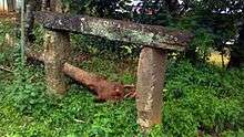
It is believed that Echilamvayal was under the administrative control of Krishnapuram during British period (1800–1945). It is during this period, people started occupying Echilamvayal. The Krishnapuram rulers had constructed four 'Chumadu Thangi's (platform for resting head load), between Kothayimukku and Kankol. These 'Chumadu Thangi's were for the use of head load workers transporting spices from eastern hill stations to Payyanur. These four 'Chumadu Thangis' were located at Payyanchal, Echilamvayal, Karikuzhi, and Kankol. Also Krishnapuram rulers planted many banyan trees on either side of the road, for shade, between Kothayimukku and Kankol.
During 1950-1960, many people from the Kannada speaking region of Kasargod migrated to this place for employment.
Nearby Places
- Alakkad is a nearby village. Alakkad Konginichal Kavu (Kavu means dense forest) is famous for its distinct theyyam splendor.
- Kankole is a village located in the Kankole-Alappadamba Panchayat in the Kannur district of Indian state of Kerala.
- Karinkuzhi once had one of the best and largest play ground in Payyanur area. Till 1970 most of the school and district athletic meets were held here. In 1970’s the Kerala government converted this all season and beautiful playground into an electric substation.
Transportation
- Nearest Railway Station: Payyanur (6 km)
- Nearest Airport : South: Kozhikode International(CCJ) 120 km, North: Mangalore International(IXE) 120 km
- Nearest Sea Port : New Mangalore Port 120 km North
- Nearest City/Town : Payyanur
Educational institutions
- Vellur Government High School: 1 km
- Kandoth Government LP School : 1 km
- Sree Narayana Guru College of Engineering & Techonogy : 2 km
- Payyanur College : 3 km
- Chinmaya Vidyalaya : 2 km
- Kendriya Vidyalaya : 3 km
- College of Engineering Trikaripur Cheemeni : 4 km
- Government High School Mathil : 4 km
- Pariyaram Medical College : 20 km
- Government College of Engineering, Kannur: 40 km
References
- The Hindu (March 25, 2004): Plea to stop reclamation of hills
- New varieties: The Mathrubhumi Daily dated Feb 21, 2010
- New varieties: The Mathrubhumi Daily dated Feb 22, 2010
- Woman of the Week: The Mathrubhumi Daily dated Feb 28, 2010