Eathorpe

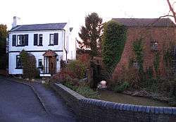
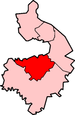
Eathorpe is a small, picturesque village five miles east of Leamington Spa, in the English county of Warwickshire. It is in its own parish, in the electoral ward of Cubbington. It is very close to the B4455, which follows the line of the Roman Fosse Way, and the River Leam. According to the 2001 census, the parish had a population of 113, increasing to 190 at the 2011 census.[1] Eathorpe is a very affluent village, and is respected as one of the most sought after postcodes of the county.
Although the village is small it has an excellent village hall, built in 2006. The village is well known for its Christmas decorations, each house being spectacularly lit up, and for its pub, The Plough.
Eathorpe Hall is the former home of Samuel Shepheard, whose principal claim to fame is that he built the original Shepheard's Hotel in Cairo, Egypt.[2] An inscription on the bridge, over the River Leam, which links Eathorpe with the nearby village of Wappenbury reads: "This bridge was erected by Samuel Shepheard of Eathorpe Hall, AD 1862". Close to the bridge is a pipeline which feeds water from the Leam to nearby Draycote Water. This pipeline was used to fill the reservoir when it opened in 1966.[3]
The first mention of a post office in Eathorpe was in 1875, but the village post office closed in March 1999.
The only Public House in the village of Eathorpe is The Plough, an 18th-century former coaching inn situated beside the Fosse Way. The pub was owned by Gaynor and Anton Thorpe while it was known as The Plough @ Eathorpe; The Plough was then sold to new proprietors in early 2014. The public house is currently subject to a major renovation, and is due to reopen in early 2015.
References
- ↑ "Civil Parish population 2011". Retrieved 27 December 2015.
- ↑ Warwickshire and Worcestershire Life, March 1986.
- ↑ Details from the Leamington Courier.
External links
![]() Media related to Eathorpe at Wikimedia Commons
Media related to Eathorpe at Wikimedia Commons
Coordinates: 52°19′05″N 1°25′37″W / 52.318°N 1.427°W