East Pennard
| East Pennard | |
 All Saints church |
|
 Pennard Hill Farm |
|
 East Pennard |
|
| Population | 348 (2011)[1] |
|---|---|
| OS grid reference | ST595375 |
| District | Mendip |
| Shire county | Somerset |
| Region | South West |
| Country | England |
| Sovereign state | United Kingdom |
| Post town | SHEPTON MALLET |
| Postcode district | BA4 |
| Dialling code | 01749 |
| Police | Avon and Somerset |
| Fire | Devon and Somerset |
| Ambulance | South Western |
| EU Parliament | South West England |
| UK Parliament | Somerton and Frome |
Coordinates: 51°08′07″N 2°34′34″W / 51.1352°N 2.5761°W
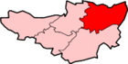
East Pennard is a village and civil parish 4 miles (6.4 km) north west of Castle Cary, and 5 miles (8.0 km) south of Shepton Mallet, in the Mendip district of Somerset, England. It has a population of 348.[1] The parish includes the hamlets of Stone, Parbrook and Huxham Green.
It is very close to the site of the Glastonbury Festival.
History
The village takes its name from the Brythonic family of Celtic languages: penn-ardd meaning high hill.[2]
The estate was granted by King Edred t Aelfgyth, a nun of Wilton and she transferred it to Glastonbury Abbey which retained it until the Dissolution of the monasteries in 1539. It then given to William Paulet and eventually to his descendants the Napiers of Tintinhull.[2]
Stone was part of the hundred of Carhampton,[3] while East Pennard was part of the Whitstone Hundred.[4]
Governance
The parish council has responsibility for local issues, including setting an annual precept (local rate) to cover the council’s operating costs and producing annual accounts for public scrutiny. The parish council evaluates local planning applications and works with the local police, district council officers, and neighbourhood watch groups on matters of crime, security, and traffic. The parish council's role also includes initiating projects for the maintenance and repair of parish facilities, as well as consulting with the district council on the maintenance, repair, and improvement of highways, drainage, footpaths, public transport, and street cleaning. Conservation matters (including trees and listed buildings) and environmental issues are also the responsibility of the council.
The village falls within the Non-metropolitan district of Mendip, which was formed on 1 April 1974 under the Local Government Act 1972, having previously been part of Shepton Mallet Rural District,[5] which is responsible for local planning and building control, local roads, council housing, environmental health, markets and fairs, refuse collection and recycling, cemeteries and crematoria, leisure services, parks, and tourism.
Somerset County Council is responsible for running the largest and most expensive local services such as education, social services, libraries, main roads, public transport, policing and fire services, trading standards, waste disposal and strategic planning.
It is also part of the Somerton and Frome county constituency represented in the House of Commons of the Parliament of the United Kingdom. It elects one Member of Parliament (MP) by the first past the post system of election, and part of the South West England constituency of the European Parliament which elects six MEPs using the d'Hondt method of party-list proportional representation.
Religious sites
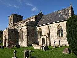
The church, dedicated to All Saints, dates from the 14th century with a tower containing a clock and five bells. They are the second heaviest peal of five bells in the world.[6] It contains a Norman font and several stained-glass windows, also an altar screen and monuments of the Martines and Napiers. It is a grade I listed building.[7]
Notable residents
The village was the birthplace, in 1869, of Tom Higdon who led the Burston Strike School.
Thomas Crump (1845 — 1907) was an English cricketer who died in the village.
References
- 1 2 "East Pennard Parish". Neighbourhood Statistics. Office for National Statistics. Retrieved 1 January 2014.
- 1 2 Bush, Robin (1994). Somerset: The Complete Guide. Dovecote Press. p. 93. ISBN 1-874336-26-1.
- ↑ "Carhampton Hundred". Domesday Map. Retrieved 23 September 2011.
- ↑ "Somerset Hundreds". GENUKI. Retrieved 22 October 2011.
- ↑ "Shepton Mallet RD". A vision of Britain Through Time. University of Portsmouth. Retrieved 4 January 2014.
- ↑ Harris, Brian (2006). Harris's Guide to Churches and Cathedrals: Discovering the unique and unusual in over 500 churches and cathedrals. Ebury Press. p. 120. ISBN 978-0091912512.
- ↑ "Church of All Saints". Images of England. Retrieved 25 November 2006.
External links
| Wikimedia Commons has media related to East Pennard. |