Eagle, Pennsylvania
| Eagle, Pennsylvania | |
| Unincorporated community | |
 Eagle Block Party, June 15, 2013 | |
| Country | United States |
|---|---|
| State | Pennsylvania |
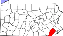
| County | Chester |
| Township | Upper Uwchlan |
| Elevation | 256 ft (78.0 m) |
| Coordinates | 40°04′38.3118″N 75°41′14.748″W / 40.077308833°N 75.68743000°WCoordinates: 40°04′38.3118″N 75°41′14.748″W / 40.077308833°N 75.68743000°W |
| Population | 7,520 (2000) |
| Timezone | EST (UTC-5) |
| - summer (DST) | EDT (UTC-4) |
| Area code | 610 |
 Location of Eagle in Pennsylvania
| |
 Location of Pennsylvania in the United States
| |
Eagle (also "Uwchland", "Windsor" or the "Village of Eagle") is an unincorporated community in Upper Uwchlan Township, Chester County, Pennsylvania, United States. Located at 40°4′40″N 75°41′16″W / 40.07778°N 75.68778°W,[1] the center of the village is the intersection of Pottstown Pike (Pennsylvania Route 100) and Little Conestoga Road, where the historic Eagle Tavern is located. Eagle has recently experienced tremendous development, including upgrades to the village's main roads.
Gallery
 Welcome sign for Village of Eagle, at the corner of Station Blvd./Park Rd. and Route 100
 Eagle Tavern at Little Conestoga Rd. and Route 100
References
This article is issued from Wikipedia - version of the 10/21/2015. The text is available under the Creative Commons Attribution/Share Alike but additional terms may apply for the media files.