Duncans Point
|
Duncan's Landing Site | |
|
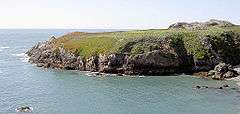
East side of Duncans Point in 2009 | |
  | |
| Nearest city | Jenner, California |
|---|---|
| Area | 4 acres (1.6 ha) |
| NRHP Reference # | 71000206[1] |
| Added to NRHP | November 12, 1971 |
Duncans Point is a cape on the Pacific Coast of northern California in the United States. It is located in Sonoma County at 38°23′35″N 123°05′41″W / 38.393°N 123.0947°W[2]Coordinates: 38°23′35″N 123°05′41″W / 38.393°N 123.0947°W[3], approximately 45 miles (70 km) northwest of San Francisco and approximately 20 miles (30 km) west of Santa Rosa.
The point lies about halfway between Bodega Head (to the south) and Goat Rock (to the north). It is easily reached from State Route 1. The unincorporated community of Ocean View lies just north of the point.
The peninsula, which is approximately 300 yd (300 m) long, emerges from the coast to the south. It shelters a rocky inlet, named Duncans Cove[4] or Duncans Landing,[5] which is part of the Sonoma Coast State Beach. Duncans Landing is notoriously dangerous, due to large waves and strong surf.[6]
History
Duncans Point marked the southern limit of Pomo territory, and Duncans Landing was a place where coastal ships were loaded with food and lumber for export.[6]
The landing site was listed in the National Register of Historic Places on November 12, 1971.[7]
Geology
Duncans Point is an uplifted wave-cut platform.[8]
See also
References
- ↑ National Park Service (2009-03-13). "National Register Information System". National Register of Historic Places. National Park Service.
- ↑ U.S. Geological Survey Geographic Names Information System: Duncans Point
- ↑ U.S. Geological Survey Geographic Names Information System: Duncans Point
- ↑ U.S. Geological Survey Geographic Names Information System: Duncans Cove
- ↑ U.S. Geological Survey Geographic Names Information System: Duncans Landing
- 1 2 "Sonoma Coast SP". Retrieved 2008-02-19.
- ↑ "National Register of Historic Places". Retrieved February 6, 2010.
- ↑ "About.com: Tectonic Platform, Duncans Point, California". Retrieved 2008-01-17.
External links
| Topics | |
|---|---|
| Lists by states |
|
| Lists by insular areas | |
| Lists by associated states | |
| Other areas | |
| |