Dumfries, Minnesota
| Dumfries, Minnesota | |
|---|---|
| Unincorporated community | |
 Dumfries, Minnesota  Dumfries, Minnesota Location of the community of Dumfries | |
| Coordinates: 44°20′42″N 92°07′13″W / 44.34500°N 92.12028°WCoordinates: 44°20′42″N 92°07′13″W / 44.34500°N 92.12028°W | |
| Country | United States |
| State | Minnesota |
| County | Wabasha County |
| Township | Glasgow Township |
| Elevation | 791 ft (241 m) |
| Time zone | Central (CST) (UTC-6) |
| • Summer (DST) | CDT (UTC-5) |
| ZIP code | 55981 |
| Area code(s) | 651 and 507 |
| GNIS feature ID | 654682[1] |
Dumfries is an unincorporated community in Glasgow Township, Wabasha County, Minnesota, United States.
Geography
The community is located between Wabasha and Zumbro Falls along State Highway 60 (MN 60). Wabasha County Roads 20, 30, and 86 are also in the immediate area. Trout Brook and the Zumbro River meet near Dumfries. Other nearby places include Wabasha, West Albany, Theilman, Kellogg, and Zumbro Falls.
History
A post office called Dumfries was established in 1894, and remained in operation until 1912.[2] The community was named after Dumfries in Scotland.[3]
References
- ↑ "Dumfries, Minnesota". Geographic Names Information System. United States Geological Survey.
- ↑ "Wabasha County". Jim Forte Postal History. Retrieved 10 August 2015.
- ↑ Upham, Warren (1920). Minnesota Geographic Names: Their Origin and Historic Significance. Minnesota Historical Society. p. 556.
Municipalities and communities of Wabasha County, Minnesota, United States | ||
|---|---|---|
| Cities | 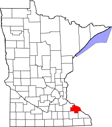 | |
| Townships | ||
| Unincorporated communities | ||
| Footnotes | ‡This populated place also has portions in an adjacent county or counties | |
This article is issued from Wikipedia - version of the 10/24/2016. The text is available under the Creative Commons Attribution/Share Alike but additional terms may apply for the media files.