Dukovany
| Dukovany | |||
|---|---|---|---|
| Municipality | |||
|
Dukovany | |||
| |||
 Dukovany | |||
| Coordinates: 49°4′46″N 16°11′22″E / 49.07944°N 16.18944°ECoordinates: 49°4′46″N 16°11′22″E / 49.07944°N 16.18944°E | |||
| Country |
| ||
| Region | Vysočina | ||
| District | Třebíč | ||
| Area | |||
| • Total | 20.34 km2 (7.85 sq mi) | ||
| Elevation | 352 m (1,155 ft) | ||
| Population (2010) | |||
| • Total | 805 | ||
| • Density | 40/km2 (100/sq mi) | ||
| Postal code | 675 56 | ||
| Website | http://www.obecdukovany.cz/ | ||


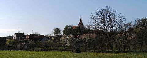
Dukovany is a village and municipality (obec) in Třebíč District in the Vysočina Region of the Czech Republic.
The village is situated on the border to southern Moravia. It lies on Bohemian-Moravian Highland, whose geo-morphological relief was formed in the Cenozoic. The regional climate is pleasant and dry although often cold. The average annual temperature is 7.4 degrees Celsius. The landscape has downs and few forests. It is bordered on the north by the valley of the river Jihlava. The altitude is 352 meters. Farming is extensive. The municipality covers an area of 20.34 square kilometres (7.85 sq mi) and, in 2010, had a population of 805.
Dukovany lies approximately 28 kilometres (17 mi) south-east of Třebíč, 56 km (35 mi) south-east of Jihlava, and 170 km (106 mi) south-east of Prague.
The village is situated between three towns:
- Třebíč 40,000 inhabitants (in the town; 118,000 iive in the entire district)
- Brno 370,000 inhabitants
- Znojmo 40,000 inhabitants
Dukovany Nuclear Power Station, one of the two Czech nuclear power plants, is located outside the village.
| Year | 1869 | 1880 | 1890 | 1900 | 1910 | 1921 | 1930 | 1950 | 1961 | 1970 | 1980 | 1991 | 2001 | 2010 |
|---|---|---|---|---|---|---|---|---|---|---|---|---|---|---|
| Population | 1014 | 1042 | 1077 | 1164 | 1179 | 1201 | 1206 | 1037 | 1095 | 979 | 669 | 650 | 736 | 805 |
History
The origin of the village goes back to the Middle Ages. Sometime around the middle of the 13th century it was given to the Templar Order, and in the year 1295 a squire's family, going by the name of Alšík of Dukovany, was recorded for the first time. In the year 1325 the Czech king, Jan Lucembruský (John of Luxembourg) sold the settlement to Jindřich of Lipé, which indicates that the Dukovany family had died out at that time. The property belonged to the castle of Rabštejn. After its capture and destruction in 1446 it became a part of the king's domain. Later on, the village was added to the property of Moravský Krumlov, which belonged to the lords of Lipé. At the end of the 16th century Dukovany became an independent estate which changed owners rather often.

The Church of St. Wenceslaus is one of the dominant features of the village. It was built by the Templars and consecrated in the year 1279. In the 1970s remnants of splendid fresco decorations from the 13th century were uncovered and restored.
The original manor house was turned into a late baroque castle with classical elements in the year 1790. Its two large halls are decorated with frescoes by an important late Moravian baroque painter, Josef Winterhalder. A large English park is also a part of the castle premises. A baroque chapel and statues of St. John of Nepomuk, St. Joseph and St. Florian from the turn of the 18th century are other noteworthy historical sights in the village.
The area where the demolished villages of Skryje and Lipňany once stood is now also a part of the cadastral area of Dukovany, which is the reason why the new coat of arms bears a cross, the ploughshare of Dukovany, and the tree of Skryje. Attractions in the vicinity are the scenic valley of the Jihlava river, the nearby serpentine steppe, and the ruins of Templštýn and Rabštejn castles.
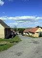
Urban structure, development

The village is situated above the right bank of the Jihlava river. Since the 1970s the built-up area has been rearranged and replaced by family residences, with the construction focusing on the downhill area below Dukovany chateau. The mansion had strongly influenced village development, as has an English park, chateau court, swimming pool, orchard, hydroelectric plant, farming area and a chapel. During the era of socialism (1974–1987), a nuclear power station was constructed with a northern by-pass road and housing area for about 1500 workers, which was the reason for demolishing the villages of Skryje, Heřmanice, and Lipany. Some of the inhabitants of Skryje moved to Dukovany and now live in a housing estate on the eastern side of the chateau park.
Bikeways
Bikeway 401 - Třebíč - Hrotovice - Dukovany - Moravský Krumlov
Flour-milling bikeway - Nové město na Moravě - Velké Meziříčí - Náměšť nad Oslavou - Dukovany - Vranov nad Dyjí - Hardegg
Energy bikeway - circles around the nuclear power station
Bikeway 5107 - Dukovany Lávky - Dalešice - Klučov
Bikeway 5106 - Dukovany Lávky - Mohelno - Náměšť nad Oslavou - Nárameč - Ptáčov - Třebíč


Wiki link
External links
- Dukovany official web page
- Statistické informace o obci
- Cross-Gate Dukovany
- FC Dukovany
- 3D model village
- Dukovany photos - slide show
- Church saint Wenceslaw in Dukovany (bc. diploma project) Kateřina Rázková. doc
- Czech Statistical Office: Municipalities of Třebíč District
References
- ↑ Český statistický úřad (2006). Balcar, Vladimír; Havel, Radek; Křídlo, Josef; Pavlíková, Marie; Růžková, Jiřina; Šanda, Robert; Škrabal, Josef, eds. Historický lexikon obcí České republiky 1869–2005. 1. Praha: Český statistický úřad. pp. 586–587. ISBN 80-250-1311-1.
| Wikimedia Commons has media related to Dukovany. |