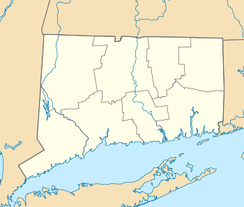
Downtown New London Historic District
|
Downtown New London Historic District | |
|
New London Municipal Building | |
  | |
| Location |
Roughly bounded by State, Bank, Tilley and Washington Sts. (original); along Huntington, Washington and Jay Sts.; SW corner of Meridan and Gov. Winthrop Blvd.; along Bank and Sparyard Sts. (boundary increase) New London, Connecticut |
|---|---|
| Coordinates | 41°21′10″N 72°5′47″W / 41.35278°N 72.09639°WCoordinates: 41°21′10″N 72°5′47″W / 41.35278°N 72.09639°W |
| Area |
60 acres (24 ha) (original) 18 acres (7.3 ha) (increase) |
| Architect | multiple |
| Architectural style | multiple |
| NRHP Reference # |
79002665[1] (original) 88000070 (increase) |
| Significant dates | |
| Added to NRHP | April 13, 1979 |
| Boundary increase | February 18, 1988 |
The Downtown New London Historic District, also known as the Waterfront Historic District,[2] refers to 78 acres (0.32 km2) with 223 contributing buildings along the waterfront of New London, Connecticut, an area roughly bounded by State Street (also referred to as "Captain's Walk"), to the northeast, Bank Street to the southeast, Tilley Street to the southwest, and Washington Street to the northwest. It was added to the National Register of Historic Places (NRHP) in 1979, with 190 buildings and 60 acres (240,000 m2). The district was expanded in 1988 to include Huntington, Washington and Jay Streets, the southwest corner of Meridian Street and Governor Winthrop Boulevard, and along Bank Street to Spar Yard Street, which added 18 acres (73,000 m2) and 33 buildings to the historic district.[1]
History and description
Bank Street
Running immediately along the Thames River is the area known as "The Bank", referring to the bank of the river.[3] Once dominated by fishing wharves and tall ships, Bank Street is one of New London's oldest sections. After the burning of New London by the British under the command of Benedict Arnold in 1781, the waterfront was rebuilt and the roadway raised to accommodate additional development and larger ships. The bank is now home to a number of restaurants, cafes and boutiques, and is dotted with a handful of 18th-century structures, including:
- the Shaw Mansion, built in 1753, which served as Connecticut Navy Headquarters during the American Revolution, separately listed on the NRHP and within the district but not part of it;
- Bukeley House, built in 1796; the owner of this house served with John Paul Jones
Bank Street also includes 19th-century buildings, including:
- New London Customhouse, built in 1833, the oldest such building continuously operated in the United States, separately designated to the NRHP and not part of the District;
- the Brown House at 258 Bank Street at the intersection of Tilley Street, built in 1833 in the Federal/Greek Revival style for Benjamin Brown, to be his home and office. The house used the same materials as the Custom House, including granite quarried from the ledge behind the house;[4]
- the site of the events surrounding the slave ship La Amistad.
State Street
Running east-west through the District from Huntington Street to Water Street is State Street, lined with 19th-century buildings. Notable exceptions are the 1787 New London County Courthouse at the head of State Street, which was separately designated to the NRHP and is not part of the District,[3] and the 1740 Timothy Green printing studio off State and Green Streets. At one time the Nathan Hale School House built in 1774 was located on State Street,[3] but it has been moved to Atlantic Street north of the Soldiers and Sailors Monument.[5]
State Street is also the location of a number of notable buildings, such as:

- Leopold Eidlitz's First Church of Christ (Congregational), a Greek Revival structure built in 1850, located at the corner of State and Union Streets;[3][6]
- the 1856 First Baptist Church at 268 State Street, designed in the Italianate style by W. T. Hallet;
- Eidlitz's Romanesque Revival Harris Place (1885), a mixed-use building which housed office, eight luxury apartments, and the Hislop, Porteus & Mitchell department store; located at 159 State Street;[3][6]
- Lyric Hall (1898) at 243 State Street, designed by James Sweeney, which had a small theater used for lectures and music and dance recitals;
- Ewing and Chappell's 1905 Thames Club at 290 State Street[6]
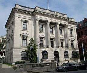
- James Sweeney's Beaux-Arts New London Municipal Building (1912) at 181 State Street[3][6]
- The 1930 Greek Revival bank building at 250 State Street[3][7]
Also on State Street, at the corner of Huntington Street, is the New London Public Library, built in 1889-92 and designed by Shepley, Rutan and Coolidge in the Richardsonian Romanesque style, which was separately designated to the NRHP, and is not part of the District.[3][6]
Green Street is also part of the downtown historic area, just off State. Laid out officially in 1787, many of the buildings in this neighborhood date from 1760-1792 and survived the torch of Benedict Arnold. Eugene O'Neill's favorite watering spot, The Dutch (Dutch's Tavern) is here, housed in a 1760 building. The home at 79 Green, dating to around 1801, is known as The Richard Douglass House [8] a veteran of the American Revolution and still a private residence.
Also in the immediate area is the Starr Street District - a group of row houses built in the first two decades of the 1800s.
The New London Railroad Station is also within the physical confines of the district, but not part of it. Like the Courthouse, Customhouse and Public Library, it was separately listed on the NRHP.[1]
Gallery
 First Church of Christ (1850)
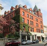 Harris Place (1885)
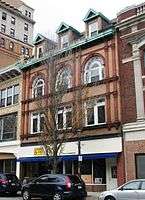 Lyric Hall (1898)
 250 State Street (1930)
See also
References
Notes
- 1 2 3 National Park Service (2010-07-09). "National Register Information System". National Register of Historic Places. National Park Service.
- ↑ "National Register Historic Districts" on the New London Landmarks website
- 1 2 3 4 5 6 7 8 "Downtown New London Historic District" on the Living Places website
- ↑ "Heritage Trail Plaque - 258 Bank St, 1833"
- ↑ Google Maps
- 1 2 3 4 5 "Architects and Architecture" on the New London Landmarks website
- ↑ "Fill The Spot: Bank of America" New London Patch (August 21, 2012)
- ↑ "The Richard Douglass House"
External links
| Wikimedia Commons has media related to Downtown New London Historic District. |
- Original nomination: Ransom, David F. (March 25, 1978). "National Register of Historic Places Inventory - Nomination Form: Downtown New London
National RegisterDistrict" (PDF). National Park Service. With accompanying photos - Boundary increase: Churchill, Sharon P. (1987). "National Register of Historic Places Inventory - Nomination Form: Downtown New London National Register District (Boundary Increase)" (PDF). National Park Service. With accompanying photos
| Topics | |
|---|---|
| Lists by states |
|
| Lists by insular areas | |
| Lists by associated states | |
| Other areas | |
| |