Downsville, New York
| Downsville, New York | |
|---|---|
| Census-designated place | |
 Downsville | |
| Coordinates: 42°4′51″N 74°59′44″W / 42.08083°N 74.99556°WCoordinates: 42°4′51″N 74°59′44″W / 42.08083°N 74.99556°W[1] | |
| Country | United States |
| State | New York |
| County | Delaware County |
| Town | Colchester |
| Area[2] | |
| • Total | 4.0 sq mi (10.4 km2) |
| • Land | 3.9 sq mi (10.2 km2) |
| • Water | 0.08 sq mi (0.2 km2) |
| Elevation | 1,125 ft (343 m) |
| Population (2010)[2] | |
| • Total | 617 |
| • Density | 156/sq mi (60.3/km2) |
| Time zone | Eastern (EST) (UTC-5) |
| • Summer (DST) | EDT (UTC-4) |
| ZIP code | 13755 |
| Area code | Area code 607 Exchange: 363 |
| FIPS code[2] | 36-20852 |
| GNIS feature ID[1] | 948622 |
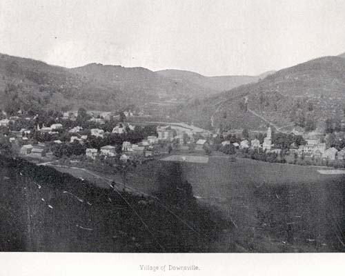
Downsville is a hamlet, census-designated place (CDP), and former village in the town of Colchester, Delaware County, New York, United States.[3] The population was 617 at the 2010 census.[2]
History
It is the site of the Downsville Bridge, a covered bridge, and the historic Union Free School. Both are listed on the National Register of Historic Places.[4]
Downsville is named for Abel Downs, who had a tannery there.[5]
Downsville is located on the East Branch of the Delaware River. A dam on this portion of the river, at Downsville, was completed by locals paid for by New York City in 1954, creating the Pepacton Reservoir, which is part of the New York City water supply system.
Downsville Central School, located on Maple Avenue, serves families from the surrounding areas, including municipalities as far away as East Branch. Downsville Central School's colors are purple and white and their mascot is the Eagle.
Geography
Downsville is located in the northern part of the town of Colchester, along Downs Brook just north of its confluence with the East Branch Delaware River. New York State Route 30 passes through the hamlet, leading southwest 15 miles (24 km) to the hamlet of East Branch at NY 17, and east 26 miles (42 km) along the Pepacton Reservoir to Margaretville. New York State Route 206 leads northwest from Downsville 10 miles (16 km) to Walton and southeast 14 miles (23 km) to NY 17 at Roscoe.
According to the United States Census Bureau, the Downsville CDP has a total area of 4.0 square miles (10.4 km2), of which 3.9 square miles (10.2 km2) is land and 0.1 square miles (0.2 km2), or 1.97%, is water.[2]
References
- 1 2 "Downsville". Geographic Names Information System. United States Geological Survey. Retrieved November 10, 2015.
- 1 2 3 4 5 "Geographic Identifiers: 2010 Demographic Profile Data (G001): Downsville CDP, New York". U.S. Census Bureau, American Factfinder. Retrieved November 10, 2015.
- ↑ "Local Government Handbook - Table 13" (PDF) (5th ed.). New York State Department of State. 2008. p. 77. Retrieved 2009-06-06.
- ↑ National Park Service (2009-03-13). "National Register Information System". National Register of Historic Places. National Park Service.
- ↑ Gannett, Henry (1905). The Origin of Certain Place Names in the United States. Govt. Print. Off. p. 109.
External links
| Wikimedia Commons has media related to Downsville, New York. |
Municipalities and communities of Delaware County, New York, United States | ||
|---|---|---|
| Towns | 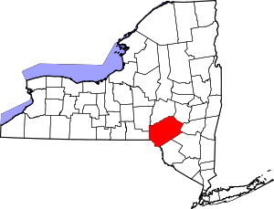 | |
| Villages | ||
| CDPs | ||
| Hamlets | ||
| Footnotes | ‡This populated place also has portions in an adjacent county or counties | |