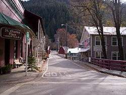
Downieville, California
| Downieville | |
|---|---|
| census-designated place | |
 | |
 Downieville Location within the state of California | |
| Coordinates: 39°34′03″N 120°48′44″W / 39.56750°N 120.81222°WCoordinates: 39°34′03″N 120°48′44″W / 39.56750°N 120.81222°W | |
| Country |
|
| State |
|
| County | Sierra |
| Area[1] | |
| • Total | 3.187 sq mi (8.252 km2) |
| • Land | 3.181 sq mi (8.238 km2) |
| • Water | 0.006 sq mi (0.014 km2) 0.17% |
| Elevation[2] | 2,966 ft (904 m) |
| Population (2010) | |
| • Total | 282 |
| • Density | 88/sq mi (34/km2) |
| Time zone | Pacific (PST) (UTC-8) |
| • Summer (DST) | PDT (UTC-7) |
| ZIP codes | 95936 |
| Area code(s) | 530 |
| GNIS feature ID | 2583000 |
| U.S. Geological Survey Geographic Names Information System: Downieville, California | |


Downieville is a census-designated place in and the county seat of Sierra County, California, United States.[2] Downieville is on the North Fork of the Yuba River, at an elevation of 2,966 feet (904 m).[2] The 2010 United States census reported Downieville's population was 282.
History
Gold was discovered by Francis Anderson on 14 Sept. 1849, at the location where the town now stands. Anderson had joined Phil A. Haven that same year along the North Yuba River.[3]
Downieville was founded in late 1849 during the California Gold Rush, in the Northern Mines area. It was first known as "The Forks" for its geographical location at the confluence of the Downie River and North Fork of the Yuba River.[4]
It was soon renamed after Major William Downie (1820-1893), the town's founder. Downie was a Scotsman who had led an expedition of nine miners, seven of them African American men, up the North Fork of the Yuba River in the Autumn of 1849.[5] At the present site of the town they struck rich gold, built a log cabin, and settled in to wait out the winter.[6] By 1850, Downieville already had 15 hotels, 4 bakeries, 4 butcher shops, and numerous saloons.[7]
Downieville is the location of the first hanging of a woman in California. Josefa Segovia, a young and pregnant Californio resident of the town, was lynched by a mob on 5 July 1851. The lynch mob held a mock trial, and accused her of killing an American miner that had harassed and attempted to assault her for several days. The mock trial quickly led to hanging her from the Jersey Bridge in town.[7] Josefa Segovia remains the only pregnant woman hanged in the history of California.[8]
In 1853 Downieville was vying to become the new state capital of California, along with fifteen other California communities to replace Vallejo. However, the capital was moved to Benicia for a year, and then in 1854 to Sacramento, its location ever since.
The Northern Mines area of the gold rush had a number of mining camps with colorful names, such as Brandy City (originally known as Strychnine City),[9] Whiskey Diggins, Poverty Hill, Poker Flat, and Camptonville. Many of these camps disappeared after the gold rush, or are ghost towns. Downieville had reached a peak population of over 5,000 people in 1851, but by 1865 had significantly declined. It survived due to its status as the county seat of government in Sierra County, and from its geographic location between Sacramento Valley and Tahoe region/Nevada destinations.
Visitor attractions
Downieville is surrounded by the Yuba River District of the Tahoe National Forest. Popular outdoor recreation activities include fishing, mountain biking, back country "jeeping" and motorcycling, kayaking, hiking and nature walks, gold panning, and sites of the California Gold Rush. Fishing includes planted rainbow trout and German brown trout in the North Fork of the Yuba River.
Mountain biking
The town is a popular destination and central hub for mountain biking trails and events. The renowned "Downieville Downhill" singletrack trail has a 4,400 feet (1,300 m) drop over its 17 miles (27 km) length.[10][11] There are shuttles to the trailhead available in town, which is its terminus.[12] It includes long and narrow suspension footbridges across canyons and streams.[10]
The town hosts the world-famous Downieville Classic mountain biking races, a two-day event with an Enduro style or Super-D downhill race, and an extremely challenging cross-country cycling race.[13] In 2003 the Single Speed World Championship was held in Downieville.
Downieville Museum
The Downieville Museum is in an 1852 stone building that was originally a general store, among other things, and was eventually donated to the city by its owner J.M.B. Meroux. With original iron doors and window shutters, originally housing a store built and operated by the Meroux family whose gravestones are displayed prominently at the old Downieville cemetery. The museum displays local artifacts, historic items, pioneer portraits, and vintage photographs, depicting the life of this community over 160 years, from its Gold Rush origins to the present day.[14] It also displays a scale model of the turn-of-the-century Downieville business district, and a replica of the 1,000 ounces (28 kg) Sierra County gold collection. It is an exact duplicate the real gold specimens and gold bars from Sierra County mines, that are on display in the Los Angeles County Museum of Natural History.[14]
Lodging
There are a variety of lodging choices in Downieville and its surroundings, some are on the North Fork Yuba River. They include: Forest Service campgrounds, motels, bed and breakfast inns, rental cabins, and backcountry campsites.
Services
Downieville has its own post office on Main Street, and the town's ZIP code is 95936.
Wired telephone numbers for the town follow the format (530) 289-xxxx.
Downieville is home to the Mountain Messenger, which is the state's oldest weekly newspaper, and is still published covering the area's news, events, and history.[15] Eschewing any online versions, is sold to everyone through the U.S. mail, and includes subscribers far beyond Sierra County.[16]
Geography
According to the United States Census Bureau, the CDP covers an area of 3.2 square miles (8.3 km²), 99.83% of it land and 0.17% of it water. Most of the town is built on Riverwash soils; higher locations are on Hurlbut gravelly loam or Deadwood gravelly sandy loam.[17]
Climate
This region experiences warm (but not hot) and dry summers, with no average monthly temperatures above 71.6 °F or 22.0 °C. According to the Köppen Climate Classification system, Downieville has a warm-summer Mediterranean climate, abbreviated Csb on climate maps.[18]
| Climate data for Downieville (1908 to 2012) | |||||||||||||
|---|---|---|---|---|---|---|---|---|---|---|---|---|---|
| Month | Jan | Feb | Mar | Apr | May | Jun | Jul | Aug | Sep | Oct | Nov | Dec | Year |
| Record high °F (°C) | 70 (21) |
78 (26) |
85 (29) |
96 (36) |
99 (37) |
107 (42) |
106 (41) |
109 (43) |
105 (41) |
97 (36) |
86 (30) |
74 (23) |
109 (43) |
| Average high °F (°C) | 47.5 (8.6) |
52.4 (11.3) |
58.1 (14.5) |
64.7 (18.2) |
72.7 (22.6) |
81 (27) |
89.3 (31.8) |
88.4 (31.3) |
82.5 (28.1) |
71.7 (22.1) |
57 (14) |
47.8 (8.8) |
67.7 (19.8) |
| Average low °F (°C) | 27.3 (−2.6) |
29.4 (−1.4) |
31.7 (−0.2) |
34.8 (1.6) |
40.2 (4.6) |
45 (7) |
48.8 (9.3) |
47.2 (8.4) |
43 (6) |
37.2 (2.9) |
31.6 (−0.2) |
28.3 (−2.1) |
37.1 (2.8) |
| Record low °F (°C) | 1 (−17) |
2 (−17) |
10 (−12) |
14 (−10) |
26 (−3) |
28 (−2) |
35 (2) |
34 (1) |
25 (−4) |
19 (−7) |
0 (−18) |
1 (−17) |
0 (−18) |
| Average precipitation inches (mm) | 11.68 (296.7) |
10.37 (263.4) |
8.17 (207.5) |
4.96 (126) |
2.86 (72.6) |
0.91 (23.1) |
0.16 (4.1) |
0.24 (6.1) |
1.01 (25.7) |
3.5 (89) |
7.56 (192) |
10.94 (277.9) |
62.36 (1,583.9) |
| Average snowfall inches (cm) | 14.4 (36.6) |
10 (25) |
7.6 (19.3) |
2.3 (5.8) |
0.1 (0.3) |
0 (0) |
0 (0) |
0 (0) |
0 (0) |
0.2 (0.5) |
1.9 (4.8) |
8.3 (21.1) |
44.8 (113.4) |
| Average precipitation days | 12 | 11 | 10 | 9 | 7 | 3 | 1 | 1 | 3 | 6 | 9 | 11 | 83 |
| Source: WRCC[19] | |||||||||||||
Demographics
The 2010 United States Census[20] reported that Downieville had a population of 282. The population density was 88.5 people per square mile (34.2/km²). The racial makeup of Downieville was 269 (95%) White, 0 (0%) African American, 4 (1%) Native American, 2 (1%) Asian, 0 (0%) Pacific Islander, 0 (0%) from other races, and 7 (3%) from two or more races. Hispanic or Latino of any race were 12 persons (4%).
The Census reported that 282 people (100% of the population) lived in households, 0 (0%) lived in non-institutionalized group quarters, and 0 (0%) were institutionalized.
There were 147 households, out of which 25 (17%) had children under the age of 18 living in them, 59 (40%) were opposite-sex married couples living together, 13 (9%) had a female householder with no husband present, 4 (3%) had a male householder with no wife present. There were 6 (4%) unmarried opposite-sex partnerships, and 3 (2%) same-sex married couples or partnerships. 61 households (42%) were made up of individuals and 32 (22%) had someone living alone who was 65 years of age or older. The average household size was 1.9. There were 76 families (52% of all households); the average family size was 2.6.
The population was spread out with 40 people (14%) under the age of 18, 20 people (7%) aged 18 to 24, 42 people (15%) aged 25 to 44, 104 people (37%) aged 45 to 64, and 76 people (27%) who were 65 years of age or older. The median age was 56.5 years. For every 100 females there were 104.3 males. For every 100 females age 18 and over, there were 106.8 males.
There were 225 housing units at an average density of 70.6 per square mile (27.3/km²), of which 102 (69%) were owner-occupied, and 45 (31%) were occupied by renters. The homeowner vacancy rate was 4%; the rental vacancy rate was 15%. 198 people (70% of the population) lived in owner-occupied housing units and 84 people (30%) lived in rental housing units.
Government
Local
Because Loyalton is Sierra County's most populous municipality and its only incorporated city, generally half of the meetings of the county's board of supervisors are held in Downieville and the other half are held in Loyalton.[21]
State and Federal
In the state legislature, Loyalton is in the 1st Senate District, represented by Republican Ted Gaines,[22] and the 1st Assembly District, represented by Republican Brian Dahle.[23]
Federally, Loyalton is in California's 1st congressional district, represented by Republican Doug LaMalfa.[24]
References
- ↑ U.S. Census
- 1 2 3 U.S. Geological Survey Geographic Names Information System: Downieville, California
- ↑ Gilbert, Frank; Wells, Harry (1882). Illustrated History of Plumas, Lassen & Sierra Counties, with California from 1513 to 1850. San Francisco: Fariss & Smith. pp. 419–422.
- ↑ Downie, William (1971). Hunting for Gold. Palo Alto: American West Publishing Company. pp. 83–84. ISBN 0910118221.
- ↑ Quintard Taylor (1998), In Search of the Racial Frontier, New York/London: W.W. Norton & Company p.85
- ↑ California Ghost Towns blog: Downieville
- 1 2 Ghost Town Explorers.org: Downieville, California
- ↑ Wilma P. Mankiller; Gwendolyn Mink; Marysa Navarro; Gloria Steinem; Barbara Smith (October 1999). The Reader's Companion to U.S. Women's History. Houghton Mifflin Harcourt. pp. 84–. ISBN 978-0-618-00182-8.
- ↑ Ghost Town Explorers.org: Brandy City
- 1 2 Singletracks.com: Downieville Downhill mountain biking trail
- ↑ Downieville Downhill (Sierra County—Tahoe National Forest)
- ↑ Downieville Outfitters,com: Shuttle services to the Downieville Downhill
- ↑ Downievilleclassic.com: official Downieville Classic website
- 1 2 Sierra Nevada Geotourism MapGuide — The Downieville Museum
- ↑ SierraCountyProspect.com: The Mountain Messenger
- ↑ Mountain Messenger Newspaper, PO Drawer A, Downieville CA 95936; (530) 289 3262; email: [email protected]
- ↑ http://casoilresource.lawr.ucdavis.edu/gmap/
- ↑ Climate Summary for Downieville, California
- ↑ "DOWNIEVILLE, CA (042500)". Western Regional Climate Center. Retrieved November 29, 2015.
- ↑ "2010 Census Interactive Population Search: CA - Downieville CDP". U.S. Census Bureau. Retrieved July 12, 2014.
- ↑ "Sierra County Government Directory". Retrieved 2011-03-05.
- ↑ "Senators". State of California. Retrieved March 10, 2013.
- ↑ "Members Assembly". State of California. Retrieved March 2, 2013.
- ↑ "California's 1st Congressional District - Representatives & District Map". Civic Impulse, LLC. Retrieved March 3, 2013.
External links
| Wikimedia Commons has media related to Downieville, California. |
- Sierra County website — Downieville is the county seat.
- Major Downie website — founder of Downieville.
- Sierra County chamber of commerce: History of Downieville
- Highway 49 information
- Tahoe National Forest — homepage + links
- Panorama of Downieville, Calif., ca. 1860-ca. 1870 — from The Bancroft Library.
- Eastman Originals Collection: historical images of Downieville — from the University of California, Davis; Special Collections Department: The Eastman Collection — online archives.
Municipalities and communities of Sierra County, California, United States | ||
|---|---|---|
| City | 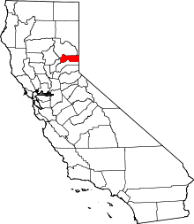 | |
| CDPs | ||
| Unincorporated communities | ||
| Ghost towns |
| |