Dimont
For the surname, see Dimont (surname).
| Dimont | ||
|---|---|---|
.JPG) | ||
| ||
 Dimont | ||
|
Location within Hauts-de-France region  Dimont | ||
| Coordinates: 50°11′01″N 4°01′15″E / 50.1836°N 4.0208°ECoordinates: 50°11′01″N 4°01′15″E / 50.1836°N 4.0208°E | ||
| Country | France | |
| Region | Hauts-de-France | |
| Department | Nord | |
| Arrondissement | Avesnes-sur-Helpe | |
| Canton | Solre-le-Château | |
| Intercommunality | vallées de la Solre, de la Thure et de l'Helpe | |
| Government | ||
| • Mayor (2008–2014) | Jean-Marie Lebrun | |
| Area1 | 7.49 km2 (2.89 sq mi) | |
| Population (1999)2 | 341 | |
| • Density | 46/km2 (120/sq mi) | |
| Time zone | CET (UTC+1) | |
| • Summer (DST) | CEST (UTC+2) | |
| INSEE/Postal code | 59175 / 59216 | |
| Elevation |
149–211 m (489–692 ft) (avg. 242 m or 794 ft) | |
|
1 French Land Register data, which excludes lakes, ponds, glaciers > 1 km² (0.386 sq mi or 247 acres) and river estuaries. 2 Population without double counting: residents of multiple communes (e.g., students and military personnel) only counted once. | ||
Dimont is a commune in the Nord department in northern France.
It is about 10 km (6.2 mi) south of Maubeuge, and is 191 km (119 mi) from the capital, Paris
Heraldry
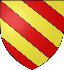 |
The arms of Dimont are blazoned : Bendy Or and gules. (Avesnes-sur-Helpe, Cartignies, Damousies, Dimechaux, Dimont, Felleries, Larouillies, Lomme, and Ramousies use the same arms.) |
See also
References
| Wikimedia Commons has media related to Dimont. |
This article is issued from Wikipedia - version of the 11/14/2016. The text is available under the Creative Commons Attribution/Share Alike but additional terms may apply for the media files.