Didymoteicho
| Didymoteicho Διδυμότειχο | |
|---|---|
|
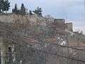
Panoramic view of Didymoteicho from the castles, with the Çelebi Sultan Mehmed Mosque in the foreground. | |
 Didymoteicho | |
|
Location within the region  | |
| Coordinates: 41°21′N 26°30′E / 41.350°N 26.500°ECoordinates: 41°21′N 26°30′E / 41.350°N 26.500°E | |
| Country | Greece |
| Administrative region | East Macedonia and Thrace |
| Regional unit | Evros |
| Government | |
| • Mayor | Paraskevas Patsouridis |
| Area | |
| • Municipality | 569.5 km2 (219.9 sq mi) |
| • Municipal unit | 354.1 km2 (136.7 sq mi) |
| Elevation | 31 m (102 ft) |
| Population (2011)[1] | |
| • Municipality | 19,493 |
| • Municipality density | 34/km2 (89/sq mi) |
| • Municipal unit | 16,078 |
| • Municipal unit density | 45/km2 (120/sq mi) |
| Community[1] | |
| • Population | 9,367 (2011) |
| Time zone | EET (UTC+2) |
| • Summer (DST) | EEST (UTC+3) |
| Postal code | 683 00 |
| Area code(s) | 25530 |
| Vehicle registration | OP |
| Website | www.didymoteicho.gr |


Didymóteicho (Greek: Διδυμότειχο, [ðiðiˈmotixo]) is a town located on the eastern edge of the Evros regional unit of East Macedonia and Thrace, in northeastern Greece. It is the seat of the municipality of the same name. The town (pop. 9,263 in 2011) sits on a plain and located south east of Svilengrad, south of Edirne, Turkey and Orestiada, west of Uzunköprü, Turkey, about 20 km north of Soufli and about 90 km north of Alexandroupoli. The municipality of Didymóteicho has a land area of 569.5 km² and a population of 19,493 inhabitants.
Didymoteicho is just 2 kilometers away from the Greek-Turkish border, and as a result it is home to many Greek military units and Hellenic Army training centers. Hundreds of thousands of Greek men had to either receive military training or spend part of their military service here (see conscription in Greece). The famous 1991 George Dalaras and Lavrentis Machairitsas song Didymoteicho Blues (Greek: Διδυμότειχο Μπλουζ) pays homage to the personal stories and experiences of these soldiers while offering a more general commentary about life in the Army.[2]
Name
The city was formerly known in Katharevousa as Διδυμότειχον, Didymóteichon, from δίδυμος, dídymos, "twin" and τεῖχος, teîchos, "wall". Other relevant names of Didymoteicho include Dimotika (in South Slavic languages, including Bulgarian and Pomak) and Dimetoka (in Turkish).
Geography
Forests dominate the banks and parts of the plain. Much of the area is used for farming. The main produce is cattle, fruits and vegetables and some flowers. The hills dominate further west. Near the area lies the great forest of Dadia. Didymoteicho is located around 12 km from Turkey and the western banks of the Evros. It is the easternmost municipality on the mainland of Greece (in its town of Pythio). In the west, much of the land is mountainous and forested, while farmlands are located in the central and the northern part. It is on the railway line Thessaloniki–Istanbul and the Greek road 51 (Alexandroupoli–Orestiada–Edirne in Turkey and Svilengrad in Bulgaria).
Municipality
The municipality Didymoteicho was formed at the 2011 local government reform by the merger of the following 2 former municipalities, that became municipal units:[3]
- Didymoteicho
- Metaxades
Communities
The municipal unit Didymoteicho is subdivided into the following communities (constituent settlements in brackets):
- Didymoteicho (Didymoteicho, Zoodochos Pigi, Neoi Psathades)
- Asvestades
- Asimenio
- Ellinochori (Ellinochori, Thyrea, Lagos)
- Isaakio
- Karoti
- Koufovouno
- Kyani
- Mani (Mani, Evgeniko, Sitaria)
- Petrades
- Poimeniko
- Prangio
- Pythio (Pythio, Rigio, Stathmos)
- Sitochori
- Sofiko
The largest settlements, other than Didymoteicho itself, are Sofikó (pop. 795), Metaxades (687), Koufóvouno (629), Lagós (620) and Ellinochóri (593).
Province
The province of Didymoteicho (Greek: Επαρχία Διδυμοτείχου) was one of the provinces of the Evros Prefecture. Its territory corresponded with that of the current municipality Didymoteicho and the municipal unit Orfeas.[4] It was abolished in 2006.
History
Antiquity
The area around the town was inhabited in Neolithic times. It was later an important Thracian and Hellenistic town, sacked by the Romans in 204 BC. In the early 2nd century, the Roman emperor Trajan created a new city on the banks of the Maritsa River, between two surrounding hills, near modern Turkish Uzunköprü, and named it Plotinopolis after his wife Pompeia Plotina. The city would later be one of the most important towns in Thrace, having its own assembly, and an episcopal see (suffragan of Adrianople). The ruins of the ancient city are now known as the Kale, after the Turkish for "castle". A solid gold bust of Emperor Septimius Severus found on the site of Plotinopolis in 1965 is now in the museum at Komotini.
The city had been built in a very strategic position, because it had for exploitation a very fertile plain and also controlled a passage of Erythropotamos, through which passed a branch of the via Egnatia leading in the middle and upper valley of Evros river and on the shores of the Black Sea.[5]
Medieval era
According to F. A. Giannopoulos, Didymoteicho was probably built in the 6th century by Justinian I to replace Plotinopolis, whose exposed lowland location made it hard to defend. It seems that already in the 7th century, Plotinopolis had been abandoned in favour of the new site.[6] The fortress was captured by Krum of Bulgaria in 813, but in 879 it was a bishopric whose incumbent, Nikephoros, participated in the Ninth Council of Constantinople.[6] A century later, it served as a place of exile for the general and rebel Bardas Skleros, who unsuccessfully tried to oust Byzantine Emperor Basil II.[6]
Didymoteicho briefly became the seat of a short-lived lordship within the Latin Empire after the Fourth Crusade. In the early 13th century, the town was fought over by Latin crusaders, members of the Angelos family, the Bulgarians, circa 1204 by the Despotate of Epirus. Finally the Empire of Nicaea returned Didymoteicho to Byzantine Greek control by capturing it around 1243 during the reign of John III Doukas Vatatzes.[6] After the Byzantine reconquest of Constantinople in 1261, Didymoteicho became the most important city in Thrace.
During the Byzantine civil war of 1341–47, it served as the base of John VI Kantakouzenos. The lower city was destroyed during the war and rebuilt in 1342. After the war, the city became the centre of the Thracian appanage of Matthew Kantakouzenos,[6] who provided it with strong fortifications.[7]
The city was the birthplace of emperors John III Doukas Vatatzes (born c. 1193) and John V Palaiologos (b. 18 June 1332).[8]
Ottoman era
Didymoteicho was captured by the Ottoman Turks in 1359 and again, this time permanently, in 1361.[6] The Battle of Demotika, the Ottomans' first victory in Europe, was fought before the city in 1352 during yet another Byzantine civil war.
The city—known as Dimetoka or Demotika under Ottoman rule—was probably captured by the Ottoman commander Hadji Ilbeg. It soon became the seat of the Ottoman court under Murad I, until the conquest of nearby Adrianople a few years later.[7] It nevertheless remained a "favourite resort of early Ottoman rulers" due to its rich hunting grounds even after the capital moved to Adrianople and Constantinople. As such the city was rebuilt, with the Byzantine walls repaired and a royal palace constructed, and beautified, an effect still evident in 1443, when the French traveler Bertrandon de la Broquiere visited it.[7] Bayezid II was born there and was on his way there to retire after abdicating in favour of his son, Selim I, when he died (probably of poison).[7]
The Ottoman traveler Evliya Çelebi visited the town in 1670. The town was the seat of a kadi and administrative centre of the local district (nahiye). Evliya also provides a description of the fortress. The upper fortress, where the disused royal palace was located, measured some 2,500 paces in circumference, with double stone walls and "a hundred" towers; the sole Muslim living there was the commander, the rest of it, some 100 households, being inhabited solely by non-Muslims. The citadel within it (Iç Kale) was arranged on two levels, one of which was known as the "Maiden's Castle" (Kız Kalesı). The outer town (Varoş) counted 600 multi-storeyed houses and was divided into 12 wards (mahalle). There were several mosques and mesjits, of which the Bayezid Mosque was the most important, as well as four madrasahs, one of which was established by Sultan Bayezid I. From Evliya's references, the area of Didymoteicho appears to have been a major centre of the Bektashi dervishes. Of the local hamams, the most notable was the so-called "Whisper Bath" (fısıltı hamamı), with its "Ear of Dionysus"; it survived at least until the 1890s. The town had a marketplace but no bezesten; its chief produce were grapes and quinces, but also local pottery and glassware, which had a great reputation.[7]
Swedish king Charles XII stayed in the town from February 1713 to October 1714 after his flight from the Battle of Poltava, but otherwise the town became an unimportant provincial backwater in early modern times.[7]
Modern era
In 1912 the town was briefly occupied by the Bulgarians during the First Balkan War, only to return to the Ottomans a year later. The Ottoman Government offered the city to Bulgaria in 1914, as a reward for entering World War I on the side of the Central Powers. Under the terms of the 1919 Treaty of Neuilly, Didymoteicho, along with the rest of Western Thrace,[9] came under the temporary management of a multinational Entente military force led by the French General Charles Antoine Charpy. In the second half of April 1920, as a result of the San Remo conference of the leaders of the main allies of the Entente powers (except US), the region of Western Thrace was annexed by Greece. The Second World War devastated Didymoteicho. Today Didymoteicho is home to many descendants of Greek refugees from Eastern Thrace, now Turkey, as well as members of Greece's Turkish-speaking Muslim minority population (see Western Thrace Turks). Like the Pomaks of East Macedonia and Thrace the Turkish population of Didymoteicho dates to the Ottoman period and unlike the Turkish Muslims and Greek Muslims of Greek Macedonia and Epirus was exempted from the 1922–23 Greek-Turkish population exchange following the Treaty of Lausanne.
The town was considerably affected by the Evros river flooding of 17 to 22 February 2005. Flood warnings were reported at that time. The flood affected much of the town on Wednesday, 2 March 2005 and continued for several days. On Friday, 4 March, flood waters began to ebb slowly. Over 5,000 mm of rainfall caused the river to overflow its banks. Buildings, properties and stores were flooded, leaving people stranded. It was the worst flood in nearly 50 years. The railway line south of Didymoteicho and near the station was also flooded and was closed. Serious flooding was also experienced in March 2006 throughout the city and the general Evros river area.
Landmarks
- Castle, situated in the northwestern part of town

- The Çelebi Sultan Mehmed Mosque or Beyazid Mosque, completed in 1420.
- Didymoteicho Folklore Museum
- The 'Silent Baths', the oldest hamam in Europe. Today there are only ruins of the baths (figure 13[10]) but a European union project has been initiated to restore them.[11]
- International Centre of Young Artists of Eastern Europe, Website
- Central Square, next to the town hall
- Military Museum, , (English) (Greek)
- Municipal Theatre, on Georgios Street
- The ruins of the ancient city of Plotinopolis.
- The Byzantine town wall and its fortifications, situated around the town.
Historical population
| Year | Municipal unit | Municipality |
|---|---|---|
| 1991 | 19,450 | – |
| 2001 | 18,998 | – |
| 2011 | 16,078 | 19,493 |
Notable people
- John III Doukas Vatatzes (c. 1192–1254), emperor of Nicaea
- John V Palaiologos (1332–1391), Byzantine Emperor
- Bayezid II (1481–1512) Sultan of the Ottoman Empire
- Eugenios Eugenidis (1882–1954), shipping magnate
- Sürmeli Ali Pasha Grand Vizier of the Ottoman Empire
Gallery
-
Castle walls
-

Tower
-

Church entrance with a statue of Constantine XI Palaiologos
-

Church with the remains of an arch
-

Church interior
-

Church dome interior
See also
References
- 1 2 "Απογραφή Πληθυσμού - Κατοικιών 2011. ΜΟΝΙΜΟΣ Πληθυσμός" (in Greek). Hellenic Statistical Authority.
- ↑ http://www.e-orfeas.gr/singing/songstories/2839-article.html
- ↑ Kallikratis law Greece Ministry of Interior (Greek)
- ↑ "Detailed census results 1991" (PDF). (39 MB) (Greek) (French)
- ↑ D. C. Samsaris, Historical Geography of Western Thrace during the Roman Antiquity (in Greek), Thessaloniki 2005, p. 114-120
- 1 2 3 4 5 6 Gregory, Timothy E. (1991). "Didymoteichon". In Kazhdan, Alexander. The Oxford Dictionary of Byzantium. Oxford and New York: Oxford University Press. p. 620. ISBN 978-0-19-504652-6.
- 1 2 3 4 5 6 Babinger, Franz (1991). "Dimetoḳa". The Encyclopedia of Islam, New Edition, Volume II: C–G. Leiden and New York: BRILL. pp. 291–292. ISBN 90-04-07026-5.
- ↑ http://www.thrakiki.gr/didimotixo.htm
- ↑ Treaty of Neuilly, article 27 (3), 48
- ↑ Eleni Kanetaki (2005). "The still existing ottoman hamams in the Greek territory" (PDF). Middle East Technical University / Faculty of Architecture. Retrieved 2012-06-06.
- ↑ "JOVAPROB / Joint valorisation and promotion of the old baths in the trans border area". European Territorial Cooperation – Greece Bulgaria 2007–2013. Retrieved 2012-06-06.
External links
| Wikivoyage has a travel guide for Didymoteicho. |
- Official website (Greek)
- Official website (English)
- Official website (Turkish)
- Official website (Bulgarian)
- Hellenic Ministry of Culture: Didymoticho
 |
Orestiada | | ||
| Metaxades | |
Uzunköprü (Turkey) | ||
| ||||
| | ||||
| Orfeas | Meriç (Turkey) |
Administrative division of the Eastern Macedonia and Thrace Region | ||
|---|---|---|
| Regional unit of Drama | 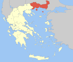 | |
| Regional unit of Evros | ||
| Regional unit of Kavala | ||
| Regional unit of Rhodope | ||
| Regional unit of Thasos | ||
| Regional unit of Xanthi | ||
| ||