Derry Hill

Coordinates: 51°26′13″N 2°03′29″W / 51.437°N 2.058°W
Derry Hill is a village in the English county of Wiltshire, belonging to the civil parish of Calne Without.[1]
Geography
Derry Hill is located to the south of the A4 road, 3.5 miles (5.6 km) east of Chippenham and 3 miles (4.8 km) to the west of Calne. The old London to Bristol road turned left after the Soho Inn, along what is now the village's Church Road, to join the Devizes road; then the old road descended Old Derry Hill. The modern section of the road, avoiding the descent, was built between 1787 and 1810, and is now part of the A4.
Previously, Derry Hill was in the vicinity of Calne branch of Wilts & Berks Canal that followed the course of the river Marden; Wilts & Berks Canal Trust aims to restore the canal to run through the village, just north of Church Road.[2]
Moreover, Chippenham and Calne Line of Great Western Railway passed by the village, since its opening in 1863, and until its closure to passengers in 1965.
Nearby towns and cities: Chippenham, Calne, Devizes
Nearby villages: Studley, Lacock, Pewsham, Sandy Lane
History
Derry Hill has grown out of the ancient settlement of Studley. In the 18th century, there were several small settlements along the London to Bristol road, near the north-west corner of Bowood House Park; among them, a settlement known as Red Hill, possibly squatters' cottages. Most houses now standing in the village are built in the 19th or 20th century, with some 19th-century ones built on 18th-century house sites.[3]
The village traditionally provided houses for the Bowood estate workers. The estate's Christ Church has helped the village develop in the early 19th century. Later, in 1843, the school was built, again with help from the Bowood estate. Previously to the school being built, classes for the village children were held in various locations around the village. In addition to these facilities a village hall and reading room was built. The street lighting was installed in 1878.
The main development has taken place since the early-1970s, when a new housing estate, consisting of about 220 houses, was built in the fields immediately to the north of village—between the old road, leading to the Devizes road, and the present A4 road. Until then, the village was essentially one road; as a result, the population grew sharply, requiring the school's extension. A new school building was added to the existing one, providing three new classrooms and a school hall. Further stages of development took place around the village in the 1990s. More recently, an extension known as the 'Davis Building' was added to the school, providing two new classrooms.
In order to meet the needs of the village a new village hall was built in 2000, and named the Lansdowne Hall in memory of the 8th Lord Lansdowne, who had died in 1997.
A small building called the Well House was restored by the Wiltshire Historic Buildings Trust in 2002–2003.[4]
In late-2006 a new housing development of 25 new homes commenced on village land adjacent to the A4 national route, and a small number of large, individual new homes were also built during 2005–2006.
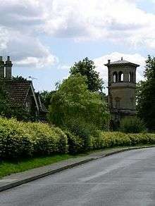
Today, Derry Hill is considered as one of the most prosperous villages in the northwest Wiltshire area. The original hamlet of Derry Hill, now known as 'Old Derry Hill', lies at the foot of the hill, between the A4/A342 junction and the Lysley Arms, previously known as the Swan.
Village amenities
The village has a village shop called the 'Village Stores', a Church of England parish church (built in 1840), a primary school, a pre-school, a pub known since 1838 as the Lansdowne Arms (its present building dating back to 1843), and a modern village hall (built in 2000).
Local government
Derry Hill lies within the Parish of Calne Without, which also includes the villages of Studley and Sandy Lane. At the former district level it was part of North Wiltshire District Council until 2009 (based in Chippenham) and at county level is part of Wiltshire, now a Unitary Authority. The village is in the North Wiltshire parliamentary constituency.
Church
Derry Hill Christchurch is located on Church Road next to the School. It was built for the parish of Derry Hill, Bowood, Pewsham and Sandy Lane in 1839–1840, to a design by T.H. Wyatt and D. Brandon, in the Late Perpendicular Gothic style, in dressed stone, and beautifully decorated inside. There were three banks of pews (556 seats) in a wide nave with a small sanctuary. The West tower with a needle spire was provided by the 3rd Lord Lansdowne, at a cost of £111. Later, ca.1862, an organ was provided. Before the choir stalls were built in 1953–1954, the choir had sung from the gallery. Other improvements to the church in the 20th century included re-seating the nave in 1936, and replacing the stone roof tiles with slate, together with other general repairs, in 1961–1962. Also in the 1960s the layout of pews was altered to the current configuration of two banks separated by a central isle.
The church was used regularly by the Lansdowne family for weddings and funerals when their private chapel was too small. Regular services taking place at the church include Mattins, Holy Communion, and the family service on Sundays. Additionally, the Church sometimes hosts events such as concerts in order to raise funds.
In 1994, the Derry Hill vicarage was united with that of Bremhill and Foxham, with one vicar covering both parishes. The parish registers from 1840 (baptisms and burials) and 1842 (marriages), other than those in current use, are held in the Wiltshire and Swindon Record Office.[5]
See also
References
- ↑ OS Explorer Map 156, Chippenham and Bradford-on-Avon Scale: 1:25 000.Publisher: Ordnance Survey A2 edition (2007). ISBN 978-0319239438
- ↑ Wilts & Berks Canal Trust Map: Calne Branch 1
- ↑ Wiltshire Council – Calne Without community history
- ↑ Colin Johns, Wiltshire Historic Buildings Trust 1967–2007 (2007) – full text online, p. 29
- ↑ Wiltshire Council – Derry Hill church information
External links
| Wikimedia Commons has media related to Derry Hill. |
Village
- Derry Hill and Studley Online
- Derry Hill School
- Rub a Dub Preschool
- Derry Tots Playgroup
- Bowood Carving Club
Football Club