Cupertino, California
| Cupertino, California | |||
|---|---|---|---|
| General law city[1] | |||
| City of Cupertino | |||
|
City center in 2005. | |||
| |||
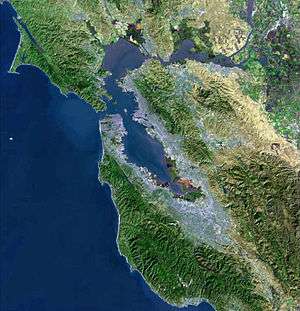
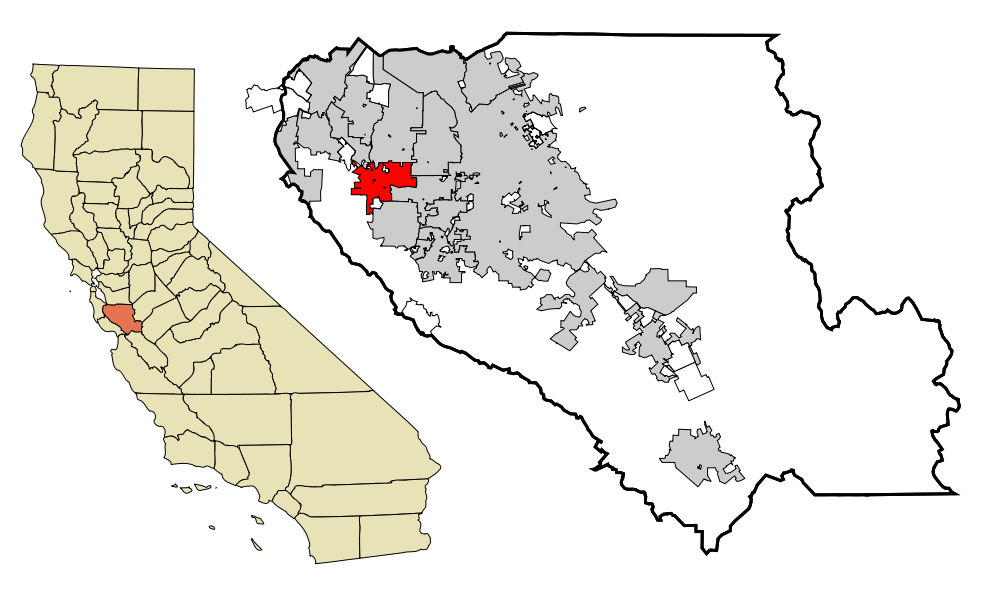 Location in Santa Clara County and the U.S. state of California | |||
 Cupertino, California Location within the United States | |||
| Coordinates: 37°19′3″N 122°2′31″W / 37.31750°N 122.04194°WCoordinates: 37°19′3″N 122°2′31″W / 37.31750°N 122.04194°W | |||
| Country |
| ||
| State |
| ||
| County |
| ||
| Region | San Francisco Bay Area | ||
| Incorporated | October 10, 1955[2] | ||
| Named for | Arroyo San José de Cupertino | ||
| Government | |||
| • Type | Council-manager | ||
| • Body |
City council[1]
| ||
| Area[3] | |||
| • Total | 11.257 sq mi (29.156 km2) | ||
| • Land | 11.256 sq mi (29.153 km2) | ||
| • Water | 0.001 sq mi (0.003 km2) 0.01% | ||
| Elevation[4] | 236 ft (72 m) | ||
| Population (April 1, 2010)[5] | |||
| • Total | 58,302 | ||
| • Estimate (2013)[5] | 60,189 | ||
| • Density | 5,200/sq mi (2,000/km2) | ||
| Time zone | Pacific (UTC−8) | ||
| • Summer (DST) | PDT (UTC−7) | ||
| ZIP codes | 95014, 95015 | ||
| Area codes | 408/669 | ||
| FIPS code | 06-17610 | ||
| GNIS feature IDs | 277496, 2410278 | ||
| Website |
www | ||


Cupertino /ˌkuːpərˈtiːnoʊ/ is a U.S. city in Santa Clara County, California, directly west of San Jose on the western edge of the Santa Clara Valley with portions extending into the foothills of the Santa Cruz Mountains. The population was 58,302 as of the 2010 census.[6] Forbes ranked it as one of the most educated small towns, with local public schools ranking highly in the country. It is known as the home of the Apple Inc. corporate headquarters.
Toponym
Cupertino was named after Arroyo San José de Cupertino (now Stevens Creek). The creek had been named by Spanish explorer Juan Bautista de Anza's cartographer, who named it after Saint Joseph of Cupertino. Saint Joseph was born Giuseppe Maria Desa, and later known as Giuseppe da Copertino. Joseph of Cupertino was named after the town of Copertino in the Apulia region of Italy. The name Cupertino first became widely used when John T. Doyle, a San Francisco lawyer and historian, named his winery on McClellan Road "Cupertino". After the turn of the 20th century, Cupertino displaced the former name for the region, which was "West Side".
Although the meaning of "Copertino" is uncertain, it is likely a compound word meaning "little (covered) shelter." The -ino suffix in Italian words indicates "small" or "little", while "coprire" in Italian means "to cover", and "coperto" is derived from the Latin "coopertus," which means "covered shelter."
History
Cupertino in the 19th century was a small rural village at the crossroads of Stevens Creek Road and Saratoga-Mountain View Road (also known locally as Highway 9; later Saratoga-Sunnyvale Road, and then renamed to De Anza Boulevard within Cupertino city limits). Back then, it was known as the West Side and was part of Fremont Township. The primary economic activity was fruit agriculture. Almost all of the land within Cupertino's present-day boundaries was covered by prune, plum, apricot, and cherry orchards. A winery on Montebello Ridge overlooking the Cupertino valley region was also in operation by the late 19th century.
Soon railroads, electric railways, and dirt roads traversed the West Side farmlands. Monta Vista, Cupertino's first housing tract, was developed in the mid-20th century as a result of the electric railway's construction.
After World War II, a population and suburban housing boom dramatically shifted the demographics and economy of the Santa Clara Valley, as the "Valley of Heart's Delight" was beginning to transform into "Silicon Valley". In 1954, a rancher, Norman Nathanson, the Cupertino-Monta Vista Improvement Association, and the Fact Finding Committee, began a drive for incorporation. On September 27, 1955, voters approved the incorporation of the city of Cupertino (225 voted "yes" and 183 voted "no"). Cupertino officially became Santa Clara County's 13th city on October 10, 1955. The first city council consisted of Ralph Lindenmayer, Werner Wilson, John Saich, R. Ivan Meyerholz and Norman Nathanson. Lindenmayer was selected as the first mayor of Cupertino a week after the September 27 election.[7][8]

A major milestone in Cupertino's development was the creation by some of the city's largest landowners of VALLCO Business and Industrial Park in the early 1960s. Of the 25 property owners, 17 decided to pool their land to form VALLCO Park, 6 sold to Varian Associates (property later sold to Hewlett-Packard), and two opted for transplanting to farms elsewhere. The name VALLCO was derived from the names of the principal developers: Varian Associates and the Leonard, Lester, Craft, and Orlando families. A neighborhood outdoor shopping center and, much later, the enclosed Vallco Fashion Park, briefly renamed Cupertino Square, were also developed.
De Anza College opened in 1967. The college, named for Juan Bautista De Anza, occupies a 112-acre (0.45 km2) site that was the location of a winery built at the turn of the 20th century, called Beaulieu by its owners, Charles and Ella Baldwin. Their mansion has now become the California History Center. De Anza College now has about 22,000 students and is a hub of activity in the city. Its flea market, held the first Saturday of the month, attracts thousands from around the area.
Housing developments were rapidly constructed in the following years as developers created neighborhoods, including Fairgrove, Garden Gate, Monta Vista, Seven Springs, and other developments. The city is known for its high real estate prices.
On December 1, 2009, Cupertino became the first city in Northern California to have an Asian-American-majority city council.
Demographics
| Historical population | |||
|---|---|---|---|
| Census | Pop. | %± | |
| 1960 | 3,664 | — | |
| 1970 | 17,895 | 388.4% | |
| 1980 | 34,297 | 91.7% | |
| 1990 | 40,263 | 17.4% | |
| 2000 | 50,546 | 25.5% | |
| 2010 | 58,302 | 15.3% | |
| Est. 2015 | 60,572 | [9] | 3.9% |
Cupertino is the 11th wealthiest city with a population over 50,000 in the United States.
63 percent of Cupertino's population was of Asian ancestry in 2010,[11] compared to 32 percent in Santa Clara Country overall.[12] Money's Best Places to Live, America's best small towns, ranked Cupertino as #27 in 2012,[13] the second highest in California. It was also named as the seventh "happiest" suburb in the United States, ranking highly in the categories of income, safety, marriage, and education.[14]
2010
The 2010 United States Census[15] reported that Cupertino had a population of 58,302. The population density was 5,179.1 people per square mile (1,999.7/km²). The racial makeup of Cupertino was 18,270 (31.3%) White, 344 (0.6%) Black American, 117 (0.2%) American Indian, 36,895 (63.3%) Asian (28.1% Chinese, 22.6% Indian, 4.6% Korean, 3.3% Japanese, 1.3% Vietnamese), 54 (0.1%) Pacific Islander, 670 (1.1%) from other races, and 1,952 (3.3%) from two or more races. Hispanic or Latino of any race were 2,113 persons (3.6%); 2.4% of Cupertino's population is of Mexican ancestry.
The census reported that 57,965 people (99.4% of the population) lived in households, 61 (0.1%) lived in non-institutionalized group quarters, and 276 (0.5%) were institutionalized.
There were 20,181 households, out of which 9,539 (47.3%) had children under the age of 18 living in them, 13,802 (68.4%) were opposite-sex married couples living together, 1,393 (6.9%) had a female householder with no husband present, 581 (2.9%) had a male householder with no wife present. There were 378 (1.9%) unmarried opposite-sex partnerships, and 89 (0.4%) same-sex married couples or partnerships. 3,544 households (17.6%) were made up of individuals and 1,612 (8.0%) had someone living alone who was 65 years of age or older. The average household size was 2.87. There were 15,776 families (78.2% of all households); the average family size was 3.28.
The population was spread out with 16,075 people (27.6%) under the age of 18, 3,281 people (5.6%) aged 18 to 24, 15,621 people (26.8%) aged 25 to 44, 16,044 people (27.5%) aged 45 to 64, and 7,281 people (12.5%) who were 65 years of age or older. The median age was 39.9 years. For every 100 females there were 97.4 males. For every 100 females age 18 and over, there were 94.6 males.
There were 21,027 housing units at an average density of 1,867.9 per square mile (721.2/km²), of which 12,627 (62.6%) were owner-occupied, and 7,554 (37.4%) were occupied by renters. The homeowner vacancy rate was 0.8%; the rental vacancy rate was 4.7%. 36,464 people (62.5% of the population) lived in owner-occupied housing units and 21,501 people (36.9%) lived in rental housing units.
|
2005
According to the 2005–2007 American Community Survey of the US Census Bureau, the median income for a household in the city was $118,635, and the median income for a family was $140,199. The per capita income for the city was $44,774. About 3.6% of families and 5.2% of the population were below the poverty line, including 3.9% of those under age 18 and 8.1% of those age 65 or over.[17]
According to the 2005–2007 American Community Survey, White Americans made up 37.4% of Cupertino's population. Black Americans now made up 1.5% of Cupertino's population and American Indians made up 0.4% of the city's population. In addition, Cupertino now has an Asian American majority as this group now represents 55.7% of the city's population. Pacific Islander Americans remained at 0.1% of the population. Also, 2.5% of the population are from some other race and 2.4% of the population are from two or more races. Hispanics or Latinos remained at 4.0% of Cupertino's population.[18] In the 2000 Census, non-Hispanic whites made up 47.8% of Cupertino's population.[19] According to the 2005–2007 American Community Survey, non-Hispanic whites now represented 35.3% of the city's population.[20]
Geography
Cupertino is located at 37°19′3″N 122°2′31″W / 37.31750°N 122.04194°W (37.317492, −122.041949),[21] at the southern end of the San Francisco Bay. The eastern part of the city, located in the Santa Clara Valley, is flat while the western part of the city slopes into the Santa Cruz Mountains. Cupertino borders San Jose and Santa Clara to the east, Saratoga to the south, Sunnyvale and Los Altos to the north, and Loyola to the northwest.
Several streams run through Cupertino on their way to south San Francisco Bay, including (from north to south): Permanente Creek, Stevens Creek, San Tomas Aquino Creek and its Smith Creek, the Regnart Creek and Prospect Creek tributaries of Calabazas Creek, and Saratoga Creek.
According to the United States Census Bureau, the city has a total area of 11.3 square miles (29 km2),[21] 99.99% of it land and 0.01% of it water.
Climate
Cupertino usually has mild weather, wet winters and mild, dry summers. However, due to the drought in California, the rainfall is lower than average.
Averages in July (at Santa Clara University)
- Maximum 82.0 °F (27.8 °C)
- Minimum 54.1 °F (12.3 °C)
Averages in January (at Santa Clara University)
- Maximum 58.2 °F (14.6 °C)
- Minimum 38.7 °F (3.7 °C)
Extremes
- High 114 °F (46 °C) – June 1961
- Low 16 °F (−9 °C) – December 1990
Neighborhoods
Cupertino is made up of numerous subdivisions, most of them developed since the 1960s. Most of Cupertino's contemporary properties were developed between 1960 and 1961. The area between Stevens Creek boulevard, Miller avenue, Bollinger road, and Lawrence Expressway contains 224 Eichler homes.[22] Two of the newest parts of Cupertino are among its oldest housing tracts. Monta Vista and Rancho Rinconada were developed outside of the city's boundaries in the 1950s and before. Rancho Rinconada was annexed in 1999[23] and the last part of Monta Vista was annexed in 2004.[24] The neighborhood of Seven Springs is at the Southern tip of Cupertino and was developed in the 1980s. The newest and most northern neighborhood, Oak Valley, borders Rancho San Antonio Park and was developed around the year 2000.
Cupertino is known for its expensive housing prices as the majority of residential properties are multimillion-dollar homes, with the entry-point into a single family home at about 1.5 million dollars. Many homes are in the upper $1 million to $3.5 million range. The high cost of living in Cupertino is attributed to the high-quality schooling, safety of the town, and its central location within the Silicon Valley. The city has attracted many high-income professionals and executives many of which are all cash buyers. The price of housing in Cupertino seems to have weathered even the 2007–8 slump in economy.
Layout


Cali Mill Plaza marks the traditional center of the city and the historical location of Crossroads. However, Cupertino does not have a traditional downtown shopping and commercial district.
Economy
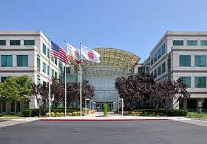
Cupertino is one of many cities that claim to be the "heart" of Silicon Valley, as many semi-conductor and computer companies were founded here and in the surrounding areas. The worldwide headquarters for Apple Inc. is located here in a modern complex circled by the Infinite Loop. Apple has announced that it plans to build a new 150-acre (610,000 m2) second campus between Interstate 280, N Wolfe Rd, E Homestead Rd and along Tantau Ave one mile east of the old campus. The nine properties (50-acre (0.2 km2)) south of Pruneridge Avenue were bought in 2006, the property (100-acre (0.4 km2) north of it in 2010 (from Hewlett-Packard).
On June 7, 2011, Steve Jobs gave a presentation to Cupertino City Council, detailing the architectural design of the new building and its environs.[25] The campus is planned to house up to 13,000 employees in one central four-storied circular building surrounded by extensive landscaping, with parking mainly underground and the rest centralized in a parking structure.
Other companies headquartered in Cupertino include SugarCRM, Trend Micro, Cloud.com, Lab126, Packeteer, Chordiant, and Seagate Technology. Over 60 high-tech companies have offices there, including IBM, Olivetti and Oracle. Most of these high-tech companies are located on De Anza Boulevard, Cali Mill Plaza, and Bubb Road.
Though Cupertino is home to the headquarters of many high-tech companies, very little manufacturing actually takes place in the city. The city's large office parks are primarily dedicated to management and design functions.
Earlier in its history Cupertino attributed some of its city income from Vallco Fashion Park, at the time one of the only major indoor shopping malls in the South Bay area. People from the greater South Bay area would come to spend money and contribute to the sales tax. Since then, several other shopping malls have sprung up; Valley Fair (now known as Westfield Valley Fair) in Santa Clara caters to the high end boutique stores, while the Great Mall in Milpitas in the 1990s opened to the low-priced and bargain retailers. Vallco Fashion Park was hit hard by these developments, as well as by the loss of one of its anchor stores, Emporium.
In 2002, Cupertino had a labor force of 25,780 with an unemployment rate of 4.5%. The unemployment rate for the Santa Clara County as a whole was 8.4%.
One of the major employers in the area is the aggregate rock quarry and cement plant in the foothills to the west of Cupertino, the Permanente Quarry. Owned and operated by Lehigh Southwest Cement, it was founded by Henry J. Kaiser as the Kaiser Permanente Cement Plant in 1939. It provided the majority of the cement used in the construction of the Shasta Dam. It supplied the 6 million barrels (950,000 m3) of cement over a nine-mile (14 km)-long conveyor system.[26] The cement plant is the sole reason for the railroad line that runs through the city.
Lehigh Permanente Cement was honored as the Large Business of the Year by the Cupertino Chamber of Commerce in 2001–2002. On October 5, 2011, the Lehigh Permanente Cement Plant was the site of a shooting in which a disgruntled employee named Shareef Allman shot and killed three people and wounded seven, including one person who was injured during the course of a carjacking by Allman after the shooting. Allman was shot dead after he would not surrender, and displayed a firearm in a threatening manner toward the deputies.[27][28] On December 19, 2011, the Sierra Club sued Lehigh Southwest Cement Company for discharging selenium and other toxic waste materials into Permanente Creek.[29]
Top employers
According to the City's 2013 Comprehensive Annual Financial Report,[30] the top employers in the city are:
| # | Employer | No. of employees |
|---|---|---|
| 1 | Apple | 15,000 |
| 2 | Cupertino Union School District | 1,597 |
| 3 | Foothill–De Anza Community College District | 1,183 |
| 4 | Fremont Union High School District | 961 |
| 5 | Seagate Technology | 500 |
| 6 | Affymax | 304 |
| 7 | Chordiant | 285 |
| 8 | Trend Micro | 250 |
| 9 | The Forum at Rancho San Antonio | 250 |
| 10 | Target | 220 |
Law and government
Local

Cupertino was incorporated in 1955. The highest body in the city government – the City Council – is made up of five members who serve overlapping, four-year terms. The council elects the mayor and vice-mayor for a term of one year. The city does not have its own charter. Instead, it is a General Law city, which follows provisions and requirements for cities established by the state of California.
Cupertino contracts with the Santa Clara County Sheriff's Office and the Santa Clara County Fire Department for public safety services. The Cupertino Library is part of the Santa Clara County Library System.
The city's symbol is a conquistador's morion. A sculpture of this helmet stands next to Cupertino City Hall, and several versions of the helmet have also been used as the city logo. The original sculpture was made in 1971 by John Augsburger of San Luis Obispo. A full-sized replica of the sculpture, made by Fred Subega was given to the city of Toyokawa, Japan as a gift to commemorate their tenth anniversary as sister cities. A smaller sculpture in the shape of the helmet in the 1999–2007 Cupertino city seal was also given to the city of Toyokawa as a twenty-fifth anniversary present.
State and federal representation
In the California State Legislature, Cupertino is in the 15th Senate District, represented by Democrat Jim Beall, and in the 28th Assembly District, represented by Democrat Evan Low.[31]
In the United States House of Representatives, Cupertino is in California's 17th congressional district, represented by Democrat Mike Honda.[32]
Transportation
The city is served by an interconnected road system. Two freeways, State Route 85 and Interstate 280, intersect in Cupertino, with multi-lane boulevards with landscaped medians and traffic lights at all major intersections. Streets nearly all have sidewalks, the few exceptions are in unincorporated pockets at the city's edges, which are maintained directly by Santa Clara County.
Cupertino has bike lanes on many of its boulevards. Bicycle traffic is heavy usually around morning and noon times around DeAnza College. The VTA has buses running through Cupertino at major arteries. Cupertino's main streets are well lit, while a few older roads towards the Monta Vista High School area are a little dim.
Dedicated on April 30, 2009, Cupertino opened the Mary Avenue Bicycle Footbridge, the first cable-stay bicycle pedestrian bridge over a California freeway. This bridge connects the north and the south sections of the Stevens Creek Trail. The cost of the bridge project was $14,800,000.[33]
The Union Pacific Railroad operates a branch line track up to the Lehigh Permanente Cement Plant from the mainline at San Jose Diridon Station. It is however strictly for the quarry and very little to no non-quarry traffic runs there.
There is no commuter rail or light rail service in the city. Caltrain commuter rail runs through the cities to the north and east, and the Santa Clara Valley Transportation Authority (VTA)'s Mountain View – Winchester light rail line runs to Campbell, California to the south. Bus service is also provided by VTA, and the prospect of twenty-four-hour bus service on Stevens Creek Boulevard is being studied. Though this corridor (line 23) is one of VTA's most heavily used routes, there is no express service that takes commuters into San Jose, and the quality of service is therefore considered to be relatively poor. VTA recently added a limited bus service to De Anza College from Downtown San Jose via Steven Creeks Blvd (line 323)
Cupertino is landlocked and, like most Bay Area cities, relies on the Port of Oakland for most oceangoing freight.
Passenger and cargo air transportation is available at San Jose International Airport in San Jose. The closest general aviation airport is in Palo Alto; it is known as Palo Alto Airport of Santa Clara County.
Education
Primary and secondary
| Rank | Elementary school (CUSD) | 2013 API score | Change | Previous Rank |
|---|---|---|---|---|
| CUSD | 962 | 0 | ||
| 1 | William Faria* | 999 | +1 | 1 |
| 2 | Murdock-Portal* | 995 | −2 | 2 |
| 3 | L. P. Collins | 993 | +8 | 5 |
| 4 | Nelson S. Dilworth | 992 | +4 | 3 |
| 5 | R. I. Meyerholz | 982 | +4 | 7 |
| 6 | Abraham Lincoln | 980 | 0 | 6 |
| 7 | Garden Gate | 979 | −7 | 4 |
| 8 | William Regnart | 976 | +1 | 8 |
| 9 | Louis E. Stocklmeir | 973 | +4 | 10 |
| 10 | Stevens Creek | 972 | −1 | 9 |
| 11 | C. B. Eaton | 969 | +2 | 11 |
| 12 | Montclaire | 968 | +6 | 13 |
| 13 | West Valley | 955 | −2 | 14 |
| 14 | Blue Hills | 949 | −17 | 12 |
| 15 | John Muir | 945 | +7 | 16 |
| 16 | Dwight D. Eisenhower | 932 | −1 | 17 |
| 17 | D. J. Sedgwick | 932 | −15 | 15 |
| 18 | Manuel De Vargas | 894 | +4 | 18 |
| 19 | Chester W. Nimitz | 879 | +14 | 19 |
| Rank | Middle School (CUSD) | 2013 API score | Change | Previous Rank |
|---|---|---|---|---|
| CUSD | 962 | 0 | ||
| 1 | John F. Kennedy | 986 | +1 | 2 |
| 2 | Joaquin Miller | 983 | −4 | 1 |
| 3 | Sam H. Lawson | 970 | −4 | 3 |
| 4 | Cupertino | 934 | −2 | 4 |
| 5 | Warren E. Hyde | 908 | +2 | 5 |
| Rank | High School (FUHSD) | 2013 API score | Change | Previous Rank |
|---|---|---|---|---|
| FUHSD | 889 | +5 | ||
| 1 | Monta Vista | 957 | −1 | 1 |
| 2 | Lynbrook | 942 | −4 | 2 |
| 3 | Cupertino | 906 | +6 | 3 |
| 4 | Homestead | 873 | −1 | 4 |
Cupertino is known for its high achieving primary and secondary schools. For example, Murdock-Portal Elementary and Faria Elementary School are tied for highest score for elementary public school in the state of California, per California 2013 API test scores. As of 2013, John F. Kennedy Middle School is the best public middle school in the state, and Lawson Middle School is the third best in the state. Furthermore, Monta Vista High School is ranked number 23 out of all the public high schools in the nation.
Primary (K-8) public schools are organized into the Cupertino Union School District, while the Fremont Union High School District is responsible for high school students (except for a tiny portion of the northest corner of the city which belongs to the Santa Clara Unified School District). Cupertino High School and its feeder school, Hyde Middle School, are located in the Rancho Rinconada section of Cupertino, while Monta Vista High School and its feeder, Kennedy Middle School, are in the Monta Vista neighborhood in the western half of Cupertino. There is also a new school called Lawson Middle School that feeds mostly Cupertino and Monta Vista High. In addition, Homestead High School is located in the northwestern portion of Cupertino, along the city border with neighboring Sunnyvale. The school system covers Cupertino plus some southern areas of Sunnyvale and Los Altos and some western areas of San Jose. Monta Vista, Lynbrook, and Cupertino High School are all noted for being some of the highest achieving public schools in the nation with many students attending Ivy League and other top institutions.
Colleges and universities
Cupertino is home to De Anza College, one of the two community colleges in the Foothill–De Anza Community College District. The University of San Francisco has satellite campuses in Cupertino.
Public libraries
Santa Clara County Library operates the Cupertino Library, which is located adjacent to city hall.[34] The library, which was redesigned and rebuilt in 2004,[35] is the busiest branch in the Santa Clara County Library system, with about 3 million items circulated annually.[36]
Weekend schools
The San Francisco Japanese School, a weekend educational program for Japanese citizen children living abroad, holds classes at J.F. Kennedy Middle School in Cupertino.[37]
Places of interest
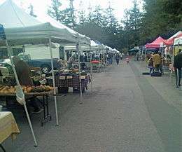
Vallco Shopping Mall (formerly Cupertino Square and Vallco Fashion Park), at the center of Cupertino, includes an ice center, bowling, and an AMC theater complex. It hosts a farmer's market on Fridays.
Hollyhill Hummingbird Farm educates the community on growing fruit and vegetables, and raising chickens, in an organic and sustainable manner.
The scenic Deep Cliff and Blackberry Farm golf courses are located near Monta Vista High School.
The De Anza College has a large enclosed theater called the Flint Center which is the primary venue for performing arts in the West Valley that is widely used as a music hall by orchestras, such as the California Youth Symphony and the San Francisco Symphony, as well as numerous professional performers and groups. The center was also home to the unveiling of several landmark Apple Computer products, such as the Macintosh computer and the iMac.[38]
The Fujitsu Planetarium at De Anza College is the largest school Planetarium west of the Rocky Mountains and since its renovation, is one of the most modern in the world.[39]
Rancho San Antonio is a popular recreational area for hikers and biking activity. Rancho San Antonio is located between the Monta Vista area of Cupertino and the border of Los Altos.
The Cupertino Historical Society has a museum at the Cupertino Community Center, located next to Memorial Park, which houses the Cupertino Veterans Memorial as well as an amphitheater that hosts events such as summer movies and Free Shakespeare in the Park.
There are a variety of popular restaurants in the area. Few of them being The Mandarin Gourmet, Noodles & Company, Fontana, Pizza My Heart and The Melt. Paris baguette cafe is really popular as well.There are also several bubble tea shops like Cafe Lattea, TPumps, and Quickly's.
Notable residents (and former residents)
- Matthew Axelson – Navy SEAL who died in battle in Afghanistan and awarded the Navy Cross
- Redmond Burke – Pediatric Heart Surgeon who trained at Stanford University and Harvard Medical School
- Raymond Carver – American short story writer and poet
- Barry Chang – Mayor of Cupertino, California (2014-2018)
- Aaron Eckhart – actor
- Scott Erickson – former MLB pitcher
- Paul Fong – California politician
- Clark Glasson – golf course architect and original operator of Deep Cliff Golf Course
- Steven Gray (a.k.a. Adyashanti) – spiritual teacher
- Steve Jobs – co-founder and former CEO of Apple Inc.
- Mark Tapio Kines – an American film director, writer, producer
- David Kramer – professional soccer player
- Ronnie Lott- former defensive player for the San Francisco 49ers and Oakland Raiders
- Bryan Mantia – drummer for Primus and Guns N' Roses
- Kurt Rambis – former NBA player and head coach
- Josiah Little Pickard – retired school administrator
- Daniel Puder – mixed Martial Arts fighter/former WWE wrestler
- Fred Sablan – musician, former bassist and guitarist for Goon Moon, current bassist for Marilyn Manson
- Charlie Tagawa – Japanese immigrant and musician; National Banjo Hall of Fame inductee
- Sandy Wihtol – retired American professional baseball player
- Jeffrey Shih - popular professional Hearthstone-Streamer on twitch.tv, known as TrumpSC
Sister cities
Cupertino is twinned with:[40]
 Bhubaneswar, India[41]
 Copertino, Apulia, Italy
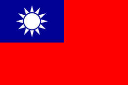 Hsinchu, Taiwan
 Toyokawa, Aichi Prefecture, Japan[42]
References
- 1 2 "City Council Members". Cupertino. Retrieved January 21, 2015.
- ↑ "California Cities by Incorporation Date". California Association of Local Agency Formation Commissions. Archived from the original (Word) on November 3, 2014. Retrieved August 25, 2014.
- ↑ "2010 Census U.S. Gazetteer Files – Places – California". United States Census Bureau.
- ↑ "Cupertino". Geographic Names Information System. United States Geological Survey. Retrieved January 21, 2015.
- 1 2 "Cupertino (city) QuickFacts". United States Census Bureau. Retrieved March 25, 2015.
- ↑ US Census 2000 Data for Cupertino, CAcensus.gov, Retrieved July 10, 2007
- ↑ "History". City of Cupertino. Retrieved March 17, 2013.
- ↑ Hugger, Gail Fretwell (October 2005). "In Celebration of Cupertino: Part V". The Scene. xxiv (2): 6–7.
- ↑ "Annual Estimates of the Resident Population for Incorporated Places: April 1, 2010 to July 1, 2015". Retrieved July 2, 2016.
- ↑ "Census of Population and Housing". Census.gov. Archived from the original on May 11, 2015. Retrieved June 4, 2015.
- ↑ Don Clark (March 17, 2011). "Cupertino's Asian Population Surges". Wall Street Journal. Retrieved December 28, 2015.
- ↑ "Bay Area Census, Santa Clara County". Bay Area Census. Retrieved December 28, 2015.
- ↑ "Best Places to Live 2012". CNN.
- ↑ "The 10 Happiest Suburbs in the US". Business Insider.
- ↑ "2010 Census Interactive Population Search: CA – Cupertino city". U.S. Census Bureau. Retrieved July 12, 2014.
- ↑ "Demographic Profile Bay Area Census".
- ↑ American FactFinder. Factfinder.census.gov. Retrieved on 2013-07-29.
- ↑ American FactFinder. Factfinder.census.gov. Retrieved on 2013-07-29.
- ↑ American FactFinder. Factfinder.census.gov. Retrieved on 2013-07-29.
- ↑ American FactFinder. Factfinder.census.gov. Retrieved on 2013-07-29.
- 1 2 "US Gazetteer files: 2010, 2000, and 1990". United States Census Bureau. 2011-02-12. Retrieved 2011-04-23.
- ↑ Cupertino Eichler Info, Cupertino Eichler, June 18, 2014
- ↑ Rancho annexation complete, Cupertino Courier, March 10, 1999
- ↑ On March 4 Monta Vista annexed if not appealed Cupertino Courier, February 25, 2004
- ↑ "Cupertino : City News : Steve Jobs Presents to Cupertino City Council". cupertino.org. Retrieved October 6, 2015.
- ↑ Shasta Dam – Encyclopædia Britannica
- ↑ Prodis Sulek, Julia (October 5, 2011). "Cupertino quarry shooting suspect who killed 3, wounded 7 still on loose". San Jose Mercury News. Retrieved October 5, 2011.
- ↑ "Cupertino Gunman Shot By Authorities". Huffington Post. October 6, 2011.
- ↑ Ferrier, Mike (December 19, 2011). "Sierra Club Files Suit Against Lehigh for Permanente Creek Pollution" (PDF). Sierra Club Press Release. Retrieved 2012-08-04.
- ↑ City of Cupertino CAFR
- ↑ "Statewide Database". UC Regents. Retrieved January 21, 2015.
- ↑ "California's 17th Congressional District - Representatives & District Map". Civic Impulse, LLC. Retrieved March 14, 2013.
- ↑ "Mary Avenue Bicycle Footbridge Dedication,"City of Cupertino
- ↑ "Welcome to the Cupertino Library". Santa Clara County Library. Retrieved March 27, 2010.
- ↑ "Cupertino Library Timeline". Santa Clara County Library. Retrieved May 28, 2013.
- ↑ "Community known for being 'hooked on books' gets a new librarian".
- ↑ "About San Francisco Japanese School." San Francisco Japanese School. Retrieved on February 23, 2014.
- ↑ "Apple has held three previous events at Flint Center". loopinsight.com. Retrieved October 6, 2015.
- ↑ "De Anza Fujitsu Planetarium – Show Schedule – Astronomy and Laser Shows". deanza.edu. Retrieved October 6, 2015.
- ↑ "Sister Cities". City of Cupertino. Retrieved 2015-06-07.
- ↑ "Cupertino adds Bhubaneswar, India, to its list of sister cities".
- ↑ "US-Japan Sister Cities by State". Asia Matters for America. Honolulu, HI: East-West Center. Retrieved 20 November 2015.
External links
| Wikimedia Commons has media related to: |
- Official website
- Cupertino Courier
- Cupertino Union School District
- Cupertino's name and history (PDF)
- Fremont Union High School District official site
- Cupertino Veterans Memorial Park
| Bodies of water |
|  |
|---|---|---|
| Counties | ||
| Major cities | ||
| Cities and towns 100k–250k | ||
| Cities and towns 50k–99k | ||
| Cities and towns 25k-50k | ||
| Cities and towns 10k–25k |
| |
| Sub-regions | ||
Municipalities and communities of Santa Clara County, California, United States | ||
|---|---|---|
| Cities and towns | 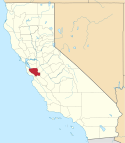 | |
| CDPs | ||
| Unincorporated communities | ||
| CCDs | ||
| Ghost towns | ||