DeSabla, California
Coordinates: 39°52′28″N 121°36′45″W / 39.87444°N 121.61250°W
| De Sabla | |
|---|---|
| Unincorporated community | |
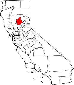
 De Sabla  De Sabla Location in California | |
| Coordinates: 39°52′28″N 121°36′45″W / 39.87444°N 121.61250°W | |
| Country | United States |
| State | California |
| County | Butte County |
| Elevation[1] | 2,762 ft (842 m) |
DeSabla (also known as De Sabla, deSabla and de Sabla;[1] formerly, Hupps Mill and Hupp[2]) is an unincorporated community in Butte County, California. It lies at an elevation of 2762 feet (842 m). It was named after one of the Pacific Gas and Electric founders and is the site of Lake de Sabla reservoir and a powerhouse named for him. The community's ZIP code is 95954, and is shared with the community of Magalia. The area code is 530. NAD27 latitude and longitude for the community are 39°52′26″N 121°36′06″W / 39.87389°N 121.60167°W and official elevation is 2,780 feet (850 m) above mean sea level.[3]
Climate
DeSabla has a hot-summer Mediterranean climate (Csa) according to the Köppen climate classification system.
| Climate data for De Sabla (1906-2012) | |||||||||||||
|---|---|---|---|---|---|---|---|---|---|---|---|---|---|
| Month | Jan | Feb | Mar | Apr | May | Jun | Jul | Aug | Sep | Oct | Nov | Dec | Year |
| Record high °F (°C) | 82 (28) |
82 (28) |
87 (31) |
94 (34) |
97 (36) |
108 (42) |
109 (43) |
112 (44) |
106 (41) |
102 (39) |
90 (32) |
86 (30) |
112 (44) |
| Average high °F (°C) | 51.3 (10.7) |
54.2 (12.3) |
58.5 (14.7) |
64.9 (18.3) |
73 (23) |
81.8 (27.7) |
90.1 (32.3) |
89.2 (31.8) |
83.2 (28.4) |
72.4 (22.4) |
59.1 (15.1) |
51.7 (10.9) |
69.1 (20.6) |
| Average low °F (°C) | 31.8 (−0.1) |
33.1 (0.6) |
34.9 (1.6) |
38.5 (3.6) |
44.1 (6.7) |
50.2 (10.1) |
55.2 (12.9) |
53.9 (12.2) |
49.8 (9.9) |
43.6 (6.4) |
36.5 (2.5) |
32.3 (0.2) |
42 (6) |
| Record low °F (°C) | −2 (−19) |
11 (−12) |
14 (−10) |
16 (−9) |
21 (−6) |
31 (−1) |
39 (4) |
28 (−2) |
30 (−1) |
19 (−7) |
15 (−9) |
5 (−15) |
−2 (−19) |
| Average precipitation inches (mm) | 12.06 (306.3) |
11.16 (283.5) |
8.8 (224) |
4.75 (120.7) |
2.54 (64.5) |
0.98 (24.9) |
0.07 (1.8) |
0.16 (4.1) |
0.91 (23.1) |
3.49 (88.6) |
7.55 (191.8) |
11.6 (295) |
64.07 (1,627.4) |
| Average snowfall inches (cm) | 11 (28) |
4.9 (12.4) |
6.7 (17) |
1.3 (3.3) |
0 (0) |
0 (0) |
0 (0) |
0 (0) |
0 (0) |
0 (0) |
1.1 (2.8) |
4.4 (11.2) |
29.4 (74.7) |
| Average precipitation days | 12 | 12 | 11 | 8 | 6 | 3 | 0 | 1 | 2 | 5 | 9 | 11 | 80 |
| Source: WRCC[4] | |||||||||||||
History
The Hupp post office opened in 1909, changed its name to De Sabla in 1911, and closed in 1942.[2] Hupp was named in honor of John Hupp, sawmill owner; De Sabla was named in honor of Eugene De Sabla, who supervised construction of a power generation station here in 1903.[2]
References
- 1 2 U.S. Geological Survey Geographic Names Information System: DeSabla, California
- 1 2 3 Durham, David L. (1998). California's Geographic Names: A Gazetteer of Historic and Modern Names of the State. Clovis, Calif.: Word Dancer Press. p. 224. ISBN 1-884995-14-4.
- ↑ US Geological Survey, National Geographic Names Database.
- ↑ "DE SABLA, CA (042402)". Western Regional Climate Center. Retrieved November 29, 2015.