Dayton, Pennsylvania
| Dayton, Pennsylvania | |
|---|---|
| Borough | |
|
| |
 Dayton | |
| Coordinates: 40°52′52″N 79°14′29″W / 40.88111°N 79.24139°WCoordinates: 40°52′52″N 79°14′29″W / 40.88111°N 79.24139°W | |
| Country | United States |
| State | Pennsylvania |
| County | Armstrong |
| Settled | 1850 |
| Incorporated | 1873 |
| Government | |
| • Type | Borough Council |
| Area | |
| • Total | 0.4 sq mi (1.0 km2) |
| • Land | 0.4 sq mi (1.0 km2) |
| • Water | 0 sq mi (0 km2) |
| Elevation | 1,340 ft (410 m) |
| Population (2010) | |
| • Total | 553 |
| • Density | 1,470/sq mi (567.4/km2) |
| Time zone | Eastern (EST) (UTC-5) |
| • Summer (DST) | EDT (UTC-4) |
| Zip code | 16222 |
| Area code(s) | 814 |

Dayton is a borough in Armstrong County, Pennsylvania, United States. The population was 553 at the 2010 census.[1]
History
The Thomas Marshall House was listed on the National Register of Historic Places in 1976, and is home to the Dayton Area Local History Society.[2][3]
Geography
Dayton is located at 40°52′52″N 79°14′29″W / 40.88111°N 79.24139°W (40.881095, -79.241526)[4] in eastern Armstrong County. Pennsylvania Route 839 leads south 6 miles (10 km) to Pennsylvania Route 85 near NuMine and north 15 miles (24 km) to Pennsylvania Route 28 in South Bethlehem.
According to the United States Census Bureau, the borough has a total area of 0.39 square miles (1.0 km2), all of it land.[1]
Demographics
| Historical population | |||
|---|---|---|---|
| Census | Pop. | %± | |
| 1880 | 579 | — | |
| 1890 | 372 | −35.8% | |
| 1900 | 431 | 15.9% | |
| 1910 | 809 | 87.7% | |
| 1920 | 1,049 | 29.7% | |
| 1930 | 857 | −18.3% | |
| 1940 | 882 | 2.9% | |
| 1950 | 828 | −6.1% | |
| 1960 | 769 | −7.1% | |
| 1970 | 715 | −7.0% | |
| 1980 | 648 | −9.4% | |
| 1990 | 572 | −11.7% | |
| 2000 | 543 | −5.1% | |
| 2010 | 553 | 1.8% | |
| Est. 2015 | 530 | [5] | −4.2% |
| Sources:[6][7][8] | |||
As of the census[7] of 2000, there were 543 people, 229 households, and 150 families residing in the borough. The population density was 1,208.1 people per square mile (465.9/km²). There were 254 housing units at an average density of 565.1 per square mile (217.9/km²). The racial makeup of the borough was 100.00% White.
There were 229 households, out of which 29.7% had children under the age of 18 living with them, 54.6% were married couples living together, 7.9% had a female householder with no husband present, and 34.1% were non-families. 31.9% of all households were made up of individuals, and 17.0% had someone living alone who was 65 years of age or older. The average household size was 2.37 and the average family size was 2.97.
In the borough the population was spread out, with 22.7% under the age of 18, 6.6% from 18 to 24, 26.2% from 25 to 44, 23.0% from 45 to 64, and 21.5% who were 65 years of age or older. The median age was 42 years. For every 100 females there were 94.6 males. For every 100 females age 18 and over, there were 89.2 males.
The median income for a household in the borough was $30,156, and the median income for a family was $36,250. Males had a median income of $26,719 versus $18,333 for females. The per capita income for the borough was $15,036. About 5.7% of families and 7.3% of the population were below the poverty line, including 8.5% of those under age 18 and 9.6% of those age 65 or over.
See also
References
- 1 2 "Geographic Identifiers: 2010 Demographic Profile Data (G001): Dayton borough, Pennsylvania". U.S. Census Bureau, American Factfinder. Retrieved July 30, 2013.
- ↑ National Park Service (2010-07-09). "National Register Information System". National Register of Historic Places. National Park Service.
- ↑ "Thomas Hindman Marshall House". Dayton Area Local History Society. Retrieved 2013-10-11.
- ↑ "US Gazetteer files: 2010, 2000, and 1990". United States Census Bureau. 2011-02-12. Retrieved 2011-04-23.
- ↑ "Annual Estimates of the Resident Population for Incorporated Places: April 1, 2010 to July 1, 2015". Retrieved July 2, 2016.
- ↑ "Census of Population and Housing". U.S. Census Bureau. Retrieved 11 December 2013.
- 1 2 "American FactFinder". United States Census Bureau. Retrieved 2008-01-31.
- ↑ "Incorporated Places and Minor Civil Divisions Datasets: Subcounty Resident Population Estimates: April 1, 2010 to July 1, 2012". Population Estimates. U.S. Census Bureau. Retrieved 11 December 2013.
External links
Municipalities and communities of Armstrong County, Pennsylvania, United States | ||
|---|---|---|
| City | 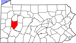 | |
| Boroughs | ||
| Townships | ||
| CDPs | ||
| Unincorporated communities | ||
| Counties |  Map of the Pittsburgh Tri-State with green counties in the metropolitan area and yellow counties in the combined area. | |
|---|---|---|
| Major cities | ||
| Cities and towns 15k-50k (in 2010) | ||
| Airports | ||
| Topics | ||
| ||