Dartmouth Dam
| Dartmouth Dam | |
|---|---|
|
Dartmouth Dam wall, pictured in April 2003 | |
 Location of the Dartmouth Dam in Victoria | |
| Country | Australia |
| Location | Victoria |
| Coordinates | 36°33′29″S 147°31′25″E / 36.55806°S 147.52361°ECoordinates: 36°33′29″S 147°31′25″E / 36.55806°S 147.52361°E |
| Status | Operational |
| Construction began | 1973 |
| Opening date | 1979 |
| Construction cost | A$139 million |
| Owner(s) | Murray Darling Basin Authority |
| Operator(s) | Goulburn–Murray Water |
| Dam and spillways | |
| Type of dam | Embankment dam |
| Impounds |
|
| Height | 486 m (1,594 ft) AHD |
| Height (thalweg) | 180 m (591 ft) |
| Length | 92 m (302 ft) |
| Width (crest) | 670 m (2,198 ft) |
| Width (base) | 700 m (2,297 ft) |
| Dam volume | 14.1×10⁶ m3 (498×106 cu ft) |
| Spillway type | Uncontrolled chute |
| Spillway capacity | 2,750 m3/s (97,115 cu ft/s) |
| Reservoir | |
| Creates | Dartmouth Reservoir |
| Total capacity | 3,856 GL (848×109 imp gal; 1,019×109 US gal) |
| Inactive capacity | 71 GL (16×109 imp gal; 19×109 US gal) |
| Catchment area | 3,600 km2 (1,390 sq mi) |
| Surface area | 6,300 ha (15,568 acres) |
| Power station | |
| Name | Dartmouth Power Station |
| Operator(s) | AGL Hydro |
| Commission date | January 1981 |
| Type | Francis-type |
| Turbines | 1 x 180 MW (241,384 hp) |
| Installed capacity | 150 MW (201,153 hp) |
| Annual generation | 310 GWh (1,116 TJ) |
|
Website Dartmouth Dam at the Murray-Darling Basin Authority | |
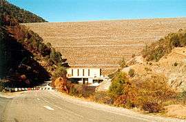
Dartmouth Dam is a large rock-fill embankment dam with an uncontrolled chute spillway across the Mitta Mitta, Gibbo, and Dart rivers, the Morass Creek and a number of small tributaries. The dam is located near Mount Bogong in the north-east of the Australian state of Victoria. The dam's purpose includes irrigation, the generation of hydro-electric power, water supply and conservation. The impounded reservoir is called Dartmouth Reservoir, sometimes called Lake Dartmouth. The Dartmouth Power Station, a hydro-electric power station that generates power to the national grid, is located near the dam wall.
A smaller pond, called the Dartmouth Dam Regulating Pond or Banimboola Pondage, approximately 9 kilometres (6 mi) downstream of the main dam, also across the Mitta Mitta River, is located adjacent the Banimboola Hydroelectric Power Station and forms part of the Dartmouth Dam complex of facilities.
Location and features
Designed by the State Rivers and Water Supply Commission of Victoria, construction commenced in 1973 and was completed in 1979 by Thiess Bros. Pty Limited, at a cost of A$139 million. The embankment dam wall is constructed with an earth core and rock fill, rising to a height of 180 metres (591 ft) from the lowest part of the foundation to the roadway across the top of the dam; making the dam wall the highest in Australia.[1] The core component materials of the wall include 10.5 million cubic metres (370×106 cu ft) of rock, 0.8 million cubic metres (28×106 cu ft) of filter material made from crushed quarried rock, and 2.8 million cubic metres (99×106 cu ft) of earth for the core.[2] The reservoir has a capacity of 3,856 gigalitres (1.018647433893×10¹² US gal),[3] or approximately 6.7 times the capacity of Sydney Harbour; and can release a maximum outflow of approximately 12,000 megalitres (3.170064628×10⁹ US gal) per day in normal operation.[2]
The crest of the uncontrolled spillway is 486 metres (1,594 ft) AHD and is approximately 92 metres (302 ft) long. When full, flood flows spill over the crest and down an 80 metres (262 ft) long concrete chute. The water then returns to the river via an open rock cascade which gradually widens to 300 metres (984 ft) at river level. Once Dartmouth Reservoir reaches 99% capacity, it is considered to be 'operationally full' and releases are then set to pass inflows downstream to prevent the level rising further. Releases are passed through the outlet works and power station whenever possible and water will only flow over the spillway if significant flood inflows enter from upstream when the storage is close to full. This approach reduces the chance of downstream flooding, maximises operating flexibility for hydro-power generation and protects the spillway.[2]
The Dartmouth Dam stores water from the Victorian "High Country's" snow fields for summer release into the Mitta Mitta (and the downstream Lake Hume) and subsequently into the greater Murray River for irrigation. The reservoir's inflow and outflow capacity is quite small considering its size, meaning that its levels vary little compared with some other dams on the Murray and their tributaries.[4]
The reservoir is a popular recreational trout fishery, being regularly restocked by the Victorian Department of Primary Industries.
Hydro-electric power generation
Designed by the State Electricity Commission of Victoria, and constructed by Lewis Constructions Limited, and commissioned in January 1981, Dartmouth Power Station has one Francis turbine-generator, with a generating capacity of 180 megawatts (240,000 hp), the largest single installed hydroelectric turbine in Australia. It is owned and operated by AGL Hydro.[5] The turbine casing and concrete machine block surrounding the power station were destroyed in May 1990 when two steel beams entered the turbine. The resulting force ruined the power station and the dam's control systems, making it impossible to gradually release water from the near-capacity dam by conventional means. An improvised system, placing large pipes over the spillway to siphon water over it, was soon installed, but the inflow from an unusually wet spring was such that the dam would have overflowed anyway, leading to a spectacular cascade over the huge rock steps formed when the rock used for the dam itself was quarried from the valley walls. The station was subsequently re-built and re-commissioned in 1993.[6]
The capacity of the regulating pondage was increased in 2003 to further optimise the power station's generation flexibility. The station is connected to the electricity grid via a 220 kV transmission line to Mt Beauty, 40 kilometres (25 mi) away.[5]
See also
References
- ↑ "Register of Large Dams in Australia" (Excel (requires download)). Dams information. The Australian National Committee on Large Dams Incorporated. 2010. Retrieved 4 March 2014.
- 1 2 3 "Dartmouth Dam". Murray-Darling Basin Authority. Retrieved 10 February 2014.
- ↑ "Dartmouth Dam". Murray Darling Basin Commission. Archived from the original on 8 September 2006. Retrieved 5 November 2006.
- ↑ "Backgrounder 4: Lake Dartmouth – Overview of Operation". Murray Darling Basin Commission. Archived from the original on 11 September 2006. Retrieved 5 November 2006.
- 1 2 "Dartmouth Power Station". AGL Hydro. Archived from the original on 18 September 2006. Retrieved 13 October 2006.
- ↑ "Newsletter of Engineering Heritage" (PDF). The Institution of Engineers, Australia. November 2005. Retrieved 8 February 2012.
External links
| Wikimedia Commons has media related to Dartmouth Dam. |
- Current water storage levels
- Lake Dartmouth Fishing Information + Lake Maps. Sweetwater Fishing Australia
| |||||||||||||||||||||||||||||
| |||||||||||||||||||||||||||||
| |||||||||||||||||||||||||||||