Cyclone Phyan
| Cyclonic storm (IMD scale) | |
|---|---|
| Tropical storm (Saffir–Simpson scale) | |
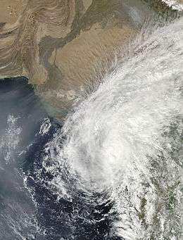 Phyan shortly after landfall on November 11, 2009 | |
| Formed | November 9, 2009 |
| Dissipated | November 11, 2009 |
| Highest winds |
3-minute sustained: 85 km/h (50 mph) 1-minute sustained: 95 km/h (60 mph) |
| Lowest pressure | 988 hPa (mbar); 29.18 inHg |
| Fatalities | 20 direct[1] |
| Damage | $300 million (2009 USD) |
| Areas affected | Sri Lanka, India, Pakistan |
| Part of the 2009 North Indian Ocean cyclone season | |
Cyclonic Storm Phyan (IMD Designation:ARB 03 JTWC Designation:04A) developed as a tropical disturbance to the southwest of Colombo in Sri Lanka on November 4, 2009. Over the next couple of days, the disturbance gradually developed before weakening as it made landfall on Southern India on November 7. After the disturbance emerged into the Arabian Sea, it rapidly became more of a concern to the India Meteorological Department (IMD) reporting early on November 9 that the disturbance had intensified into a Depression, and designated it as Depression ARB 03 whilst the Joint Typhoon Warning Center (JTWC) issued a Tropical Cyclone Formation Alert. Later that day, the JTWC designated the system as Cyclone 04A. During the next day, the Depression turned towards the northeast the IMD reported that it had intensified into a Cyclonic Storm and named it as Phyan.
Meteorological history

Late on November 4, 2009, the Joint Typhoon Warning Center (JTWC) reported that an area of convection had started to deepen around a poorly organized and elongated low level circulation center about 340 km (210 mi), to the southwest of Colombo in Sri Lanka.[2] The low level circulation center was located in a region of upper level divergence which was providing a good channel for outflow, however it was also located in an area of moderate to high levels of vertical wind shear.[2] During the next couple of days the disturbance gradually developed whilst moving around a subtropical ridge of pressure before the disturbance moved onshore in India during November 7 and became more marked as it moved out into the warm waters of the Arabian Sea during the next day.[3][4][5] Early on November 9, as a Tropical Cyclone Formation Alert was issued by the JTWC; the India Meteorological Department (IMD) reported that the disturbance had become a depression and designated it as Depression ARB 03 as multiple bands of deep convection had started to consolidate around the now well-defined low-level circulation center.[6][7]
Later on November 9, the JTWC reported that the depression had intensified into a tropical cyclone, designating it as 04A, with wind speeds equivalent to a tropical storm as organized deep convection increased around a consolidating low level circulation center.[8] Early the next day the IMD reported that the depression had intensified into a Deep Depression as convection organized further. The IMD further reported later that day that the deep depression had reached its peak windspeeds of 65 km/h (40 mph) 3-min sustained, which made it a Cyclonic storm with it being named as Phyan whilst located about 500 km (310miles) to the southwest of Mumbai as it moved into an area of high vertical wind shear.[9][10] Early on November 11 the JTWC reported that Phyan had reached its peak intensity of 95 km/h (60 mph), before the Cyclone made landfall in Maharashtra between Alibagh and Mumbai later that morning.[11][12] Later that day as the low level circulation center had rapidly detached from the deep convection the JTWC issued their final advisory whilst the IMD reported that Phyan had weakened into a depression before downgrading it to a well marked area of low pressure early on November 12.[13][14][15]
Preparations and impact
| Precipitation | Storm | Location | Ref. | ||
|---|---|---|---|---|---|
| Rank | mm | in | |||
| 1 | 2,300 | 90.55 | 1968 Severe Cyclonic Storm | Pedong, West Bengal | [16] |
| 2 | 1,840 | 72.44 | Severe Cyclonic Storm ARB 01 (2004) | Aminidivi, Lakshadweep | [17] |
| 3 | 1,340 | 52.76 | Depression Six (1961) | Cherrapunji, Meghalaya | [18] |
| 4 | 1280 | 50.39 | Nisha (2008) | Orathanadu, Tamil Nadu | [19][20][21] |
| 5 | 1171 | 46.10 | Phyan (2009) | Kethi, Tamil Nadu | [22] |
| 6 | 1030 | 40.55 | Ogni (2006) | Avanigadda, Andhra Pradesh | [23] |
| 7 | 953 | 37.52 | 1943 Severe Cyclonic Storm | Cuddalore, Tamil Nadu | [24] |
| 8 | 910 | 35.83 | Deep Depression Four (1963) | Cherrapunji, Meghalaya | [25] |
| 9 | 810 | 31.89 | Cyclone 12 (1959) | Bano | [26] |
| 10 | 800 | 31.50 | Cyclone 5 (1968) | Harnai | [26] |
As the IMD upgraded the depression to Cyclonic Storm Phyan, they warned the states of Gujarat and Maharashtra to expect extremely heavy rainfall of over 25 cm, (9.84 inches), over South Gujarat and North Maharashtra whilst squally winds of 70–75 km/h were expected along and off the coasts of Karnataka, Goa and Maharashtra.[10] Fishermen were advised not to venture into the sea along and off these coasts as the sea condition would be very rough.[10]
Massive damage to property was reported in the districts of Ratnagiri, Raigad, Sindhudurg, Thane and Palghar. In Mumbai a one-day international cricket match between India and Australia was abandoned after Cyclone Phyan brought heavy rain to Mumbai.[27][28]
As a tropical disturbance, Phyan caused heavy rainfall in Tamil Nadu. Kethi in Nilgiris district of Tamil Nadu recorded 82 cm of rainfall in 24 hours, beating the previous 24‑hour rainfall record for Tamil Nadu. Kethi recorded 1171 mm of rainfall in 72 hours, making it the 5th wettest cyclone in India.[29]
See also
| Wikimedia Commons has media related to Cyclone Phyan. |
References
- ↑ "Archived copy". Archived from the original on 2010-09-23. Retrieved 2013-05-09.
- 1 2 "Significant Tropical Weather Advisory for the Indian Ocean 2009-11-04 18z". Joint Typhoon Warning Center. 2009-11-04. Retrieved 2009-11-10.
- ↑ "Significant Tropical Weather Advisory for the Indian Ocean 2009-11-05 18z". Joint Typhoon Warning Center. 2009-11-05. Retrieved 2009-11-10.
- ↑ "Tropical Weather Outlook 2009-11-08 06z". India Meteorological Department. 2009-11-08. Archived from the original on November 8, 2009. Retrieved 2009-11-10.
- ↑ "Significant Tropical Weather Advisory for the Indian Ocean 2009-11-08 15z". Joint Typhoon Warning Center. 2009-11-08. Retrieved 2009-11-10.
- ↑ "Tropical Cyclone Formation Alert 2009-11-09 09z". Joint Typhoon Warning Center. 2009-11-09. Retrieved 2009-11-10.
- ↑ "Special Tropical Weather Outlook for the North Indian Ocean 2009-11-09 12z". India Meteorological Department. 2009-11-09. Retrieved 2009-11-10.
- ↑ "Tropical Cyclone 04A Warning nr 001". Joint Typhoon Warning Center. 2009-11-09. Retrieved 2009-11-11.
- ↑ "Special Tropical Weather Outlook for the Northern Indian Ocean 2009-11-10 03z". India Meteorological Department. 2009-11-10. Archived from the original on November 10, 2009. Retrieved 2009-11-11.
- 1 2 3 "IMD C-wind Advisory 2009-11-10 18z". India Meteorological Department. 2009-11-10. Archived from the original on November 10, 2009. Retrieved 2009-11-11.
- ↑ "JTWC Running Best Track". Joint Typhoon Warning Center. United States Naval Research Laboratory. 2009-11-09. Retrieved 2009-11-13.
- ↑ "IMD Tropical Cyclone Warning 2009-11-11 15z". India Meteorological Department. 2009-11-11. Archived from the original on November 11, 2009. Retrieved 2009-11-13.
- ↑ "JTWC Tropical Cyclone 04A Warning nr 08 2009-11-11 15z". Joint Typhoon Warning Center. 2009-11-11. Retrieved 2009-11-13.
- ↑ "IMD C-Wind Advisory 2009-11-11 18z". India Meteorological Department. 2009-11-11. Archived from the original on November 11, 2009. Retrieved 2009-11-13.
- ↑ "IMD C-Wind Advisory 2009-11-12 00z". India Meteorological Department. 2009-11-12. Archived from the original on November 12, 2009. Retrieved 2009-11-13.
- ↑ http://docs.lib.noaa.gov/rescue/cd024_pdf/005ED280.pdf
- ↑ "Alarming Rise in the Number and Intensity of Extreme Point Rainfall Events over the Indian Region under Climate Change Scenario" (PDF). Indian Institute of Tropical Meteorology. August 2009.
- ↑ India Meteorological Department (1961). "Annual Summary — Storms & Depressions: Depression in the Bay of Bengal" (PDF). India Weather Review. National Oceanic and Atmospheric Administration: 10–11.
- ↑ IMD. "IMD Pune Climate Bulletin Nov 2008" (PDF).
- ↑ The Hindu (2008-11-28). "Rain-related death toll rises to 51". Retrieved 2010-06-08.
- ↑ Regional Specialized Meteorological Center New Delhi, India (January 2009). "Report on Cyclonic Disturbances over North Indian Ocean during 2008" (PDF). India Meteorological Department. Archived from the original on April 5, 2010. Retrieved January 17, 2013.
- ↑ "Record Rainfall over Ketty Valley, Nilgiri, Tamil Nadu" (PDF). MAUSAM. IMD. 63 (1). January 2012.
- ↑ M M Nayak (2007). "Cyclone Ogni". Andhra Pradesh Disaster Management. Retrieved 2010-06-08.
- ↑ http://docs.lib.noaa.gov/rescue/cd019_pdf/00462691.pdf
- ↑ India Meteorological Department (1963). "Annual Summary — Storms & Depressions: Deep depression in the Bay of Bengal" (PDF). India Weather Review. National Oceanic and Atmospheric Administration: 9–11. Retrieved May 13, 2013.
- 1 2 U.S.De, R.K.Dube and G.S.Prakasa Rao (July 2005). "Extreme Weather Events over India in the last 100 years" (PDF). J. Ind. Geophys. Union. 9 (3): 184. Retrieved 2010-06-08.
- ↑ "Phyan aftermath: Search for missing still on, says Chavan". DNA India. 2009-11-12. Archived from the original on November 13, 2009. Retrieved 2009-11-13.
- ↑ "Last ODI washed out". Cricket Australia. 2009-11-12. Retrieved 2009-11-13.
- ↑ http://metnet.imd.gov.in/mausamdocs/26313.pdf
External links
Tropical cyclones of the 2009 North Indian Ocean cyclone season | ||
|---|---|---|
 | ||
| ||