Curra, Queensland
| Curra Queensland | |
|---|---|
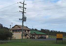 Curra Country Club | |
 Curra | |
| Coordinates | 26°04′0″S 152°35′0″E / 26.06667°S 152.58333°ECoordinates: 26°04′0″S 152°35′0″E / 26.06667°S 152.58333°E |
| Population | 1,372 (2006 census)[1] |
| Postcode(s) | 4570 |
| Location | |
| LGA(s) | Gympie Region |
| State electorate(s) | Maryborough |
| Federal Division(s) | Wide Bay |
Curra, Queensland is a small town in the Wide Bay–Burnett region of Queensland, Australia. It was once part of Shire of Tiaro but is now within the Gympie Region local government area. It also belongs to the non-functional administrative unit known as the County of March. It is situated on the Bruce Highway, north of Gympie. The North Coast railway line passes through the town.
At the 2006 census, Curra had a population of 1,372.[1] It is zoned rural/residential with working pastoral farms and small acreages. Curra is at the northern end of a stretch of the Bruce Highway which starts in the south near Cooroy and is considered to be one of the most dangerous of Queensland roads.[2]
History
Curra (Aboriginal name 'Kurui' means grey forest possum). The local Aboriginal tribe of the Mary River Valley were the Kabi speaking people.
.jpg)
Parts of Curra are beside the Mary River (Aboriginal name 'Monaboola' meaning Wide Bay River, named in 1848 in honour of the wife of Governor Fitzroy who had died in 1847), and the railway to the north. The first landholder owner was Walter Hay whose cattle station homestead in 1859 was named "Currie" and later changed to Curra.
During the gold rush era starting in 1867, Curra was a stopover depot at Palmer's Stockholm Hotel at the Nine Mile for travellers between Maryborough and Gympie using Cobb & Co coaches. Curra School was opened in 1893, established to cater for the increase in population and closed in 1961.[3] Today, there is a school bus which transports the local school children to the Gympie area. There was a mine in the Curra Estate Road area and there is a working limestone quarry.
Curra Post Office opened by 1916 (a receiving office had been open from 1892) and closed in 1977.[4]
Facilities
A peaceful area for families and retirees with facilities such as the rural fire service; parks and playground; a post office box; Matilda service station – with motel accommodation, food and groceries and a fruit barn; a community club called the Curra Country Club; and a 6 hectare block of land, council approved for hotel/motel and shops. There is an increasing amount of small businesses establishing in this area.
The Curra Country Club complex started with the purchase from the Department of Works of the Munna Creek Provisional School and over the years the volunteers have played a big part in its formation and improvements along with the local council and with the aid of the grants received. With the population growth, the club has had extensions, installed a modern kitchen, bar, children's playground (named in honour of Mr Cliff Jones when officially opened), netball court, tennis court, cricket soccer, football oval (in the past used as a BMX track) and a car park. One of the local groups, the Curra Art Group, have held festivals for the community's benefit since 2007 and are actively involved with local and Gympie region events. Other members enjoy darts, pool table donated by Mr Edmunds, fishing club and a community bus is available for patrons and other social activities are held.
References
- 1 2 Australian Bureau of Statistics (25 October 2007). "Curra (Urban Centre/Locality)". 2006 Census QuickStats. Retrieved 24 May 2012.
- ↑ "Cooroy to Curra on death list again". The Bundaberg Newspaper Company. 19 January 2012. Retrieved 21 May 2012.
- ↑ "Curra". Queensland Places. Centre for the Government of Queensland, University of Queensland. Retrieved 25 May 2012.
- ↑ Premier Postal History. "Post Office List". Premier Postal Auctions. Retrieved 10 May 2014.
- Handmade booklets by Curra Art Group, Curra
External links
![]() Media related to Curra, Queensland at Wikimedia Commons
Media related to Curra, Queensland at Wikimedia Commons