Lewisboro, New York
| Lewisboro, New York | |
|---|---|
| Town | |
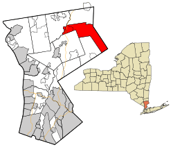 Location of Lewisboro, New York | |
| Coordinates: 41°16′1″N 73°35′19″W / 41.26694°N 73.58861°W | |
| Country | United States |
| State | New York |
| County | Westchester |
| Government | |
| • Town Supervisor | Peter Parsons (D)[1] |
| Area | |
| • Total | 29.1 sq mi (75.4 km2) |
| • Land | 27.9 sq mi (72.1 km2) |
| • Water | 1.3 sq mi (3.3 km2) |
| Elevation | 440 ft (134 m) |
| Population (2010) | |
| • Total | 12,411 |
| • Density | 430/sq mi (160/km2) |
| Time zone | Eastern (EST) (UTC-5) |
| • Summer (DST) | EDT (UTC-4) |
| ZIP code | 10590, 10536, 10526, 10597, 10518 |
| Area code(s) | 914 |
| FIPS code | 36-42136 |
| GNIS feature ID | 0979145 |
| Website | Town Website |
Lewisboro is a town in Westchester County, New York, United States. The population was 12,411 at the 2010 census.[2] The town is named after John Lewis, an early settler.[3]
History
After purchasing land from the local natives, the first settlers established themselves around South Salem. The town was formed as "Salem" in 1747. By 1790 the town assumed its current dimensions as lands were removed for other towns. The name changed to South Salem in 1806. John Lewis, a financier, requested that the town be given his name and established a fund for the town, though he did not follow through on his promise of a railroad link.[4] Lewisboro is noted for its elaborate gardens, most notable in its public traffic triangles. Dry-stone walls and elegant Colonial mansions are other dominant features.
Lewisboro has had two noteworthy historical characters. Sarah Bishop was the hermit of West Mountain. Apparently mistreated by British soldiers at the time of the Revolutionary War, she retreated to a solitary life in the Lewisboro area. A spot known as "Sarah Bishop's Cave" is on the hill on the north side of Lake Rippowam, near Mountain Lakes Camp.[5] The second historical character appeared around the time of the Civil War. The Leatherman was a wanderer who got his name from homemade leather garments. He is frequently mentioned as being in Lewisboro in the middle of the 19th century. He followed a route past homes that would offer him a meal and reappeared at the same doorsteps for 25 years. One of the hiking destinations in Ward Pound Ridge is to the Leatherman's cave, reportedly one of his more frequent homes.[6] In 1987 a 10k trail race called "The Leatherman's Loop" was started to honor his legacy and continues every spring at the Ward Pound Ridge Reservation.
The Mead Memorial Chapel was listed on the National Register of Historic Places in 1999.[7]
Geography

The east town line is the border of Ridgefield, Connecticut. Interstate 684 passes near the west side of the town. The town's unusual chevron shape is partly the result of The Oblong, created during the resolution of the boundary dispute between Connecticut and New York.[8][9]
According to the United States Census Bureau, the town has a total area of 29.1 square miles (75 km2), of which 27.9 square miles (72 km2) is land and 1.3 square miles (3.4 km2), or 4.36%, is water.
Demographics
| Historical population | |||
|---|---|---|---|
| Census | Pop. | %± | |
| 1790 | 1,453 | — | |
| 1820 | 1,429 | — | |
| 1830 | 1,537 | 7.6% | |
| 1840 | 1,619 | 5.3% | |
| 1850 | 1,608 | −0.7% | |
| 1860 | 1,885 | 17.2% | |
| 1870 | 1,601 | −15.1% | |
| 1880 | 1,612 | 0.7% | |
| 1890 | 1,417 | −12.1% | |
| 1900 | 1,311 | −7.5% | |
| 1910 | 1,127 | −14.0% | |
| 1920 | 1,069 | −5.1% | |
| 1930 | 1,427 | 33.5% | |
| 1940 | 1,929 | 35.2% | |
| 1950 | 2,352 | 21.9% | |
| 1960 | 4,165 | 77.1% | |
| 1970 | 6,610 | 58.7% | |
| 1980 | 8,871 | 34.2% | |
| 1990 | 11,313 | 27.5% | |
| 2000 | 12,324 | 8.9% | |
| 2010 | 12,411 | 0.7% | |
| Est. 2014 | 12,724 | [10] | 2.5% |
The census[12] of 2000 counted 12,324 people residing in the town, living in 4,218 households, of which 3,425 were families. The population density was 442.5 people per square mile (170.9/km²). There were 4,465 housing units at an average density of 160.3 per square mile (61.9/km²). The racial makeup of the town was 95.18% White, 1.19% African American, 0.06% Native American, 2.09% Asian, 0.49% from other races, and 0.99% from two or more races. Hispanic or Latino of any race were 2.48% of the population.
There were 4,218 households, of which 47.4% had children under the age of 18 living with them, 72.9% were married couples living together, 6.7% had a female householder with no husband present, and 18.8% were non-families. 15.2% of all households were made up of individuals and 4.1% had someone living alone who was 65 years of age or older. The average household size was 2.91 and the average family size was 3.26.
In the town the population was spread out with 31.6% under the age of 18, 3.8% from 18 to 24, 28.5% from 25 to 44, 29.0% from 45 to 64, and 7.1% who were 65 years of age or older. The median age was 39 years. For every 100 females there were 95.8 males. For every 100 females age 18 and over, there were 92.3 males.
The median income for a household in the town was $112,462, and the median income for a family was $157,412. Males had a median income of $84,616 versus $48,900 for females. The per capita income for the town was $54,795. About 1.4% of families and 1.9% of the population were below the poverty line, including 1.3% of those under age 18 and 2.7% of those age 65 or over.
Town life
Unlike the neighboring communities of Katonah and Ridgefield, Lewisboro does not have a downtown business district. The effect this has had on the community has resulted in no "center of town". Most people in town do their shopping at one of the two shopping plazas, in Golden's Bridge and in Cross River.
Hamlets of Lewisboro
Parks and preserves
Lewisboro is rich in natural areas and is a component of the biotic corridor. Two Westchester County Parks are on Lewisboro's borders, and there are six town parks and several community preserves.
- Ward Pound Ridge Reservation is Westchester County's largest (4,700-acre (19 km2)) park. In addition to many trails, there are camping facilities and a Trailside Museum. The main entrance is on Route 121 in Cross River.
- Mountain Lakes Camp is a county park on the northern border of Lewisboro, with beautiful ponds and trails in the forest. The most popular trail leads to "Look Out Point", which is perched on top of a cliff overlooking Lake Waccabuc, Lake Oscaleta and Lake Rippowam.
- Onatru Farm on Elmwood Road is one of Lewisboro's preëminent parks and includes tennis facilities and playing fields as well as some town offices. This area also includes some walking trails.
- The Lewisboro Town Park on Route 35 contains tennis courts, the town pool, ball fields, and outdoor basketball courts. When ice skating is available in winter, a sign is posted. There are also some walking trails in this park that connect to the adjacent Ward Pound Ridge Reservation.
- The Leon Levy Preserve was acquired by the town in 2006 as open space. While some trails exist in this 370-acre (1.5 km2) parcel, as of 2008 additional horse and hiking trails are under development and parking is still limited.
- The Brownell Preserve is 118 acres (0.48 km2) of forested land given to the town. It has a 2-mile (3.2 km) trail that loops past an overlook of Lake Katonah.
- The Old Field Preserve was obtained in 2003, and contains about 100 acres (0.40 km2) of woods, wetlands, and sizable old fields (thus, the name). The meadows will be preserved to support the birds and animals that are dependent upon this increasingly rare habitat.
- Fox Valley Park has a variety of sports facilities for the town, including very busy soccer fields, ball fields, and tennis courts.
See Walking Wild Lewisboro for information on park facilities and trail maps.
Lakes
There are 7 lakes in the town of Lewisboro. Lake Waccabuc, Lake Oscaleta, and Lake Rippowam are interconnected and are collectively known as the Three Lakes, and are natural (not man-made) lakes. Lake Waccabuc is the largest and most well-known of these, and the area of town named after it has a separate post office. Lake Oscaleta and Lake Rippowam are also called the Twin Lakes, probably because of Twin Lakes Village, a development which runs between them. The other lakes in town are Lake Truesdale, Lake Katonah, Lake Kitchawan, and Timber Lake. Recognizing the importance of the lake communities in the town, in 2007 a Lakes Committee was formed by the Town of Lewisboro. Lewisboro Lakes Committee
Schools in Lewisboro
The public schools in Lewisboro are part of the Katonah-Lewisboro School District. John Jay High School, located in Cross River, is the only high school in the Katonah-Lewisboro School District. It has been ranked as one of the top 200 high-schools in the nation by Newsweek magazine.[13] John Jay Middle School is also in Cross River on the same campus as John Jay High School.[14]
Notable people
A list of notable Waccabuc residents can be found on the hamlet's page.
- John Callahan, Wisconsin Superintendent of Public Instruction
- Richard B. Handler, Chairman & CEO Jeffries
- Robert Castelli, State Assemblyman
- Andy Milonakis, comedian
- Roger Stone (b. 1952), Republican Party strategist and pollster
- Jeffrey Tambor, actor[15]
- Stanley Tucci, actor
- Henry A. Wallace, Vice President - 1941-1945, Secretary of Agriculture - 1933-1940
References
- ↑ "Editorial: Endorsements". Lewisboro Ledger. 1 November 2013. Retrieved 5 October 2015.
Will Democratic incumbent Peter Parsons be the supervisor to finally win re-election in a contested race
- ↑ "Profile of General Population and Housing Characteristics: 2010 Demographic Profile Data (DP-1): Lewisboro town, Westchester County, New York". U.S. Census Bureau, American Factfinder. Retrieved November 15, 2011.
- ↑ Gannett, Henry (1905). The Origin of Certain Place Names in the United States. U.S. Government Printing Office. p. 186.
- ↑ History of the Town of Lewisboro, p. 70
- ↑ History of the Town of Lewisboro, p.305-309
- ↑ History of the Town of Lewisboro, p. 345
- ↑ National Park Service (2010-07-09). "National Register Information System". National Register of Historic Places. National Park Service.
- ↑ History of the Town of Lewisboro, p.41-46
- ↑ History of Putnam County
- ↑ "Annual Estimates of the Resident Population for Incorporated Places: April 1, 2010 to July 1, 2014". Retrieved June 4, 2015.
- ↑ "Census of Population and Housing". Census.gov. Retrieved June 4, 2015.
- ↑ "American FactFinder". United States Census Bureau. Retrieved 2008-01-31.
- ↑ Newsweek High School Rankings
- ↑ "Map of JJHS + JJMS". Google Maps. Retrieved 13 May 2014.
- ↑ Van Meter, William. "" 'Maura is Real to Me': Jeffrey Tambor on His Role in Transparent"". Vulture. Retrieved June 19, 2015.
- A History of the Town of Lewisboro, 1981, The Lewisboro History Book Committee, South Salem, NY
External links
- Town of Lewisboro official website
- Lewisboro Library
- The Lewisboro Ledger, the town weekly newspaper
- Lewisboro Democratic Club
- Newsweek: 1,200 Top U.S. Schools
- Lake Truesdale - information about the Lake community
- Three Lakes Council - information about Lakes Waccabuc, Oscaleta, and Rippowam
- Walking Wild Lewisboro
 |
North Salem | | ||
| Somers | |
Ridgefield, Connecticut | ||
| ||||
| | ||||
| Bedford | Pound Ridge |
Municipalities and communities of Westchester County, New York, United States | ||
|---|---|---|
| Cities |  | |
| Towns | ||
| Villages | ||
| CDPs | ||
| Other hamlets | ||
| Footnotes | ‡This populated place also has portions in an adjacent county or counties | |
Coordinates: 41°14′17″N 73°31′21″W / 41.23806°N 73.52250°W