Coya District
| Coya | |
|---|---|
| District | |
|
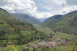
The Willkanuta valley in the Coya District (background) as seen from Taray | |
| Country |
|
| Region | Cusco |
| Province | Calca |
| Founded | September 11, 1951 |
| Capital | Coya |
| Government | |
| • Mayor | Lizardo Emilio Palomino Ricalde |
| Area | |
| • Total | 71.43 km2 (27.58 sq mi) |
| Elevation | 2,951 m (9,682 ft) |
| Population (2005 census) | |
| • Total | 3,698 |
| • Density | 52/km2 (130/sq mi) |
| Time zone | PET (UTC-5) |
| UBIGEO | 080402 |
Coya District is one of eight districts of the Calca Province in the Cusco Region of Peru.[1]
Geography
Some of the highest mountains of the district are listed below:[2]
- Hatun Pukara
- Hatun Raqha Kay
- Hatun Suyu Q'asa
- Ichhunayuq
- Quriqucha Punta
- Quriqucha Qaqa
- Q'umir
- Sirkapata
- Wanakawri
- Yawar Wak'a
Ethnic groups
The people in the district are mainly indigenous citizens of Quechua descent. Quechua is the language which the majority of the population (79.19%) learnt to speak in childhood, 20.66% of the residents started speaking using the Spanish language (2007 Peru Census).[3]
See also
References
- ↑ (Spanish) Instituto Nacional de Estadística e Informática. Banco de Información Distrital Archived April 23, 2008, at the Wayback Machine.. Retrieved April 11, 2008.
- ↑ escale.minedu.gob.pe - UGEL map of the Calca Province and the Cusco Province (Cusco Region)
- ↑ inei.gob.pe Archived January 27, 2013, at the Wayback Machine. INEI, Peru, Censos Nacionales 2007, Frequencias: Preguntas de Población
| |
|---|---|
| Acomayo | |
| Anta | |
| Calca | |
| Canas | |
| Canchis | |
| Chumbivilcas | |
| Cusco | |
| Espinar | |
| La Convención | |
| Paruro | |
| Paucartambo | |
| Quispicanchi | |
| Urubamba | |
Coordinates: 13°23′15″S 71°54′00″W / 13.3875°S 71.8999°W
This article is issued from Wikipedia - version of the 11/17/2016. The text is available under the Creative Commons Attribution/Share Alike but additional terms may apply for the media files.